Tulang Bawang Regency

Last updated
Tulang Bawang Regency
Kabupaten Tulang Bawang
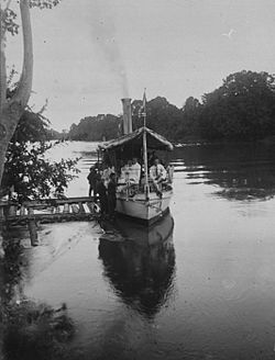
Lambang Kabupaten Tulang Bawang.gif
Motto(s): 
Sai Bumi Nengah Nyappur
(English: one land, friendly getting along)
Lokasi Lampung Kabupaten Tulang Bawang.svg
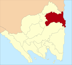
Location within Lampung
Location map Southern Sumatra.png
Red pog.svg
Tulang Bawang Regency
Location in Southern Sumatra, Sumatra and Indonesia
Indonesia Sumatra location map.svg
Red pog.svg
Tulang Bawang Regency
Tulang Bawang Regency (Sumatra)
Indonesia location map.svg
Red pog.svg
Tulang Bawang Regency
Tulang Bawang Regency (Indonesia)
Coordinates: 4°19′04″S105°30′02″E / 4.3176618°S 105.5005569°E / -4.3176618; 105.5005569
Country Flag of Indonesia.svg  Indonesia
Province Lampung
Regency seat Menggala
Government
  RegentQudrotul Ikhwan (Pj.)
Area
  Total3,466.32 km2 (1,338.35 sq mi)
Population
 (mid 2022 estimate) [1]
  Total431,208
  Density120/km2 (320/sq mi)
Human Development Index
(2022)
  HDI (2022)Increase2.svg 69,53 Medium
Time zone UTC+7 (IWST)
Postcode
345xx and 346xx
Area code (+62) 736
Vehicle registration BE xxxx S**/T*
Website tulangbawangkab.go.id

Tulang Bawang Regency (Lampung: Tuba-aksara.png ) is a regency (kabupaten) of Lampung Province, Sumatra, Indonesia. The regency was created on 3 January 1997 from the eastern half of North Lampung Regency; when created, it originally covered a much wider area, but on 29 October 2008 the 7 northern districts were separated off to form a new Mesuji Regency, and the 8 western districts were also separated off to form a new West Tulang Bawang Regency. It now has an area of 3,466.32 square kilometres (1,338.35 sq mi) and had a population of 397,906 at the 2010 Census [2] and 430,021 at the 2020 Census; [3] the official estimate as at mid 2022 was 431,208. [1] The regency seat is the town of Menggala, located about 120 kilometres (75 mi) from the provincial capital of Bandar Lampung. The regency takes its name from the Tulang Bawang River which flows through the province.

Contents

Administrative districts

The Regency comprises fifteen districts (kecamatan) which are listed below with their areas and their populations at the 2010 Census [2] and the 2020 Census, [3] together with the official estimates as at mid 2022. [1] The table also includes the locations of the district administrative centres, the number of administrative villages in each district (a total of 147 rural desa and 4 urban kelurahan - the latter all in Menggala District), and its post code.

Kode
Wilayah
Name of
District
(kecamatan)
Area
in
km2
Pop'n
2010
Census
Pop'n
2020
Census
Pop'n
mid 2022
Estimate
Admin
centre
No.
of
villages
Post
code
18.05.08 Banjar Agung 230.8835,34943,92944,290Banjar Agung1134682
18.05.20 Banjar Margo 132.9536,61440,08141,304Agung Dalem1234684
18.05.29 Banjar Baru 132.9513,01215,08015,608Kehuripan Jaya1034685
18.05.06 Gedung Aji 114.4712,02314,50714,718Gedung Ali1034681
18.05.23Penawar Aji104.4516,98820,70721,213Gedung Rejo Sakti934592
18.05.26Meraksa Aji94.7112,89415,54315,964Paduan Rajawali834680
18.05.02 Menggala 344.0041,10950,91951,574Ujung Gunung934611
- 34614
18.05.13Penawar Tama210.5325,79130,58432,245Bogatama1434593
18.05.12 Rawa Jitu Selatan
(South Rawajitu)
123.9430,75631,36331,593Medasari934591
18.05.11 Gedung Meneng 657.0737,02435,62531,724Gedung Meneng1134597
18.05.18 Rawa Jitu Timur
(East Rawajitu)
176.7528,85416,79515,094Bumi Dipasena Jaya834590
18.05.22Rawa Pitu169.1815,88318,11418,440Batang Hari934594
18.05.27Gedung Aji Baru95.3620,73024,64725,343Sidomukti934595
18.05.25 Dente Teladas 685.6559,06656,45854,556Teladas1234596
18.05.30 Menggala Timur
(East Menggala)
193.5311,81315,66915,640Lebuh Dalem1034615
- 34619
Totals3,466.32397,906430,021431,208Menggala151

History

Tulang Bawang River near Menggala, c. 1920s COLLECTIE TROPENMUSEUM Assistent-resident Rademakers maakt met gasten een tocht per boot op de Tulang Bawang rivier bij Menggala TMnr 60034994.jpg
Tulang Bawang River near Menggala, c.1920s

Early Islamization Lampung from the XIII century from Pasai is evidenced by the tombstone of Malik Al Saleh written in 1297 and the Batu Brak Site at Hanibung in 688 Hijriyah. Islam was brought by the four sons of Sultan Ratu Ngegalang Paksi. The arrival of the four pious people is a setback from the Sekala Brak kuno with the last king, queen sekekhummong (Sekerummong), the Buay Tumi tribe, who is Hindu Birawa and animist. This momentum is at the same time a milestone in the establishment of Kepaksian Paksi Pak Sekala Brak or Kepaksian Sekala Brak which is based on Islamic religious values. The four sons of Umpu Ratu Ngegalang Paksi are Sultan Ratu Buay Pernong, Umpu Nyerupa, Umpu Belunguh, Umpu Bejalan Diway. The spread of Islam throughout the land of Lampung from the 15th century started from West Lampung Regency. In 1525 Islam also entered through Labuhan Maringgai from Banten and Palembang. The entry of Islam in Tulang Bawang since the 16th century from the village of Pagar the god of the Penggala Tulang Bawang area was brought Islamic traders. [4]

The spread of the Lampung tribe began in the 13th century AD following the marriage of the only daughter Queen sekekhummong, namely Sindi La Lalula in Islam, with the descendants of Kepaksian Pernong who settled in Batu Brak, together with Putri Indar Wati (Sibulan), who opened a new village in the area of Tulang Bawang Regency. [5]

Tulang Bawang Regency was inaugurated by the Minister of Home Affairs on 20 March 1997, as a follow-up to Law no. 2 of 1997 which had provided for the establishment of both the Tulang Bawang Regency and the Tanggamus Regency. [6]

Economy

Major crops include rice, orange (a growing sector), corn, cassava, soy bean and zallaca palm fruit. As of 2010, the area under plantation in the regency is 298.943 hectares (738.70 acres), mainly rubber, coconut, oil palm and sugar cane. [7] It is particularly known though for its shrimp industry. [7]

Related Research Articles

<span class="mw-page-title-main">Lampung</span> Province of Indonesia

Lampung, officially the Province of Lampung, is a province of Indonesia. It is located on the southern tip of the island of Sumatra. It has a short border with the province of Bengkulu to the northwest, and a longer border with the province of South Sumatra to the north, as well a maritime border with the province of Banten and Jakarta to the east. It is the original home of the Lampung people, who speak their own language, and possess their own written script. Its capital is Bandar Lampung.

<span class="mw-page-title-main">East Ogan Komering Ulu Regency</span> Regency in South Sumatra, Indonesia

East Ogan Komering Ulu Regency is a regency of South Sumatra Province, Indonesia. It was created on 18 December 2003 from what had formerly been the eastern districts of Ogan Komering Ulu Regency. It covers an area of 3,370 km2 and had a population of 609,982 at the 2010 Census and 649,853 at the 2020 Census; the official estimate as at mid 2022 was 673,966. The regency seat is the town of Martapura. It borders Ogan Ilir Regency to the north, Ogan Komering Ulu Regency to the west, Ogan Komering Ilir Regency in the east and Lampung Province and South Ogan Komering Ulu Regency in the south.

<span class="mw-page-title-main">West Lampung Regency</span> Regency in Lampung, Indonesia

West Lampung Regency is a regency of Lampung Province, Sumatra, Indonesia. Until 2012 it had an area of 4,950.4 km2 of which forests occupied some 57% of the total area. It had a population of 418,560 people at the 2010 census. However, on 25 October 2012 the southwestern part of this area was separated from West Lampung Regency to form the new Pesisir Barat Regency.

<span class="mw-page-title-main">South Lampung Regency</span> Regency in Lampung, Indonesia

South Lampung Regency is a regency of Lampung, Sumatra, Indonesia, a strip of land surrounding the provincial capital of Bandar Lampung on its northern and eastern sides, and bounded to the west by the new Pesawaran Regency and to the south by the Sunda Strait; as such it is a major transit corridor to/from Java island. It has an area of 2,109.74 km2, and a population of 909,989 at the 2010 census and 1,064,301 at the 2020 census; the official estimate as at mid 2022 was 1,081,115. The regency seat is the town of Kalianda.

<span class="mw-page-title-main">East Lampung Regency</span> Regency in Lampung, Indonesia

East Lampung Regency is a regency (kabupaten) of Lampung Province, Sumatra, Indonesia. It has an area of 5,325.03 km2 and a population of 951,639 people at the 2010 census and 1,110,340 at the 2020 census. The official estimate as at mid 2022 was 1,127,946 - comprising 572,986 males and 553,960 females. The regency seat is at the town of Sukadana.

<span class="mw-page-title-main">North Lampung Regency</span> Regency in Lampung, Indonesia

North Lampung Regency is an inland regency (kabupaten) of Lampung Province, Sumatra, in Indonesia. It has an area of 2,725.63 km2 and had a population of 583,925 at the 2010 census and 633,099 at the 2020 census; the official estimate as at mid 2022 was 635,129. The regency seat is the town of Kotabumi.

<span class="mw-page-title-main">Mesuji Regency</span> Regency in Lampung, Sumatra, Indonesia

Mesuji Regency is a regency (kabupaten) of Lampung Province, on Sumatra island, Indonesia. It was created on 29 October 2008 from what were previously the most northern districts of Tulang Bawang Regency. It has an area of 2,200.51 km2 and a population of 187,286 people at the 2010 census and 227,518 at the 2020 census; the official estimate as at mid 2022 was 232,685. The regency seat is the town of Mesuji.

<span class="mw-page-title-main">Pringsewu Regency</span> Regency in Lampung, Indonesia

Pringsewu Regency is a regency of Lampung Province, Sumatra, Indonesia. It has an area of 625 km² and had a population of 364,825 people at the 2010 Census and 405,466 at the 2020 Census; the official estimate as at mid 2022 was 408,415. The regency seat is the town of Pringsewu, located 37 kilometres from the provincial capital of Bandar Lampung. The regency was created on 29 October 2008 from the former eastern part of Tanggamus Regency.

<span class="mw-page-title-main">Tanggamus Regency</span> Regency in Lampung, Indonesia

Tanggamus Regency is a regency (kabupaten) of Lampung Province, Sumatra, Indonesia. It has an area of 4,654.96 km² and had a population of 534,595 at the 2010 Census and 640,275 at the 2020 Census; the official estimate as at mid 2022 was 652,898. The regency seat is the town of Kota Agung Pusat. The regency was created on 21 March 1997, but districts in its eastern part were split away on 29 October 2008 to form a new Pringsewu Regency. It lies in the southwest of the province, and surrounds Semangka Bay on its west, north and east coasts.

<span class="mw-page-title-main">West Tulang Bawang Regency</span> Regency in Lampung, Indonesia

West Tulang Bawang Regency is a regency (kabupaten) of Lampung Province, Sumatra, Indonesia. It was created on 29 October 2008 from what were formerly the western districts of Tulang Bawang Regency. It has an area of 1,201.15 km2 and had a population of 250,707 people at the 2010 Census and 286,162 at the 2020 Census; the official estimate as at mid 2022 was 289,620. The regency seat is the town of Panaragan Jaya.

<span class="mw-page-title-main">Way Kanan Regency</span> Regency in Lampung, Indonesia

Way Kanan Regency is a landlocked regency (kabupaten) of Lampung Province, Sumatra, Indonesia. It was created on 20 April 1999 from what were formerly the northern districts of North Lampung Regency. It has an area of 3,921.63 km2 and had a population of 406,123 at the 2010 census and 473,575 at the 2020 census; the official estimate as at mid 2022 was 481,036. The administrative centre lies at the town of Blambangan Umpu.

<span class="mw-page-title-main">Pesisir Barat Regency</span> Regency in Sumatra, Indonesia

Pesisir Barat Regency is a regency in Lampung Province of Indonesia. It was created on 25 October 2012 from the eight western districts of West Lampung Regency. It covers an area of 2,907.23 km2, and had a population of 141,741 at the 2010 Census and 162,697 at the 2020 Census; the official estimate as of mid-2022 was 164,816. The administrative center is the town of Krui. The majority group in the Pesisir Barat Regency is the Lampung people.

<span class="mw-page-title-main">Lampung people</span> Ethnic group in Indonesia

The Lampung or Lampungese are an indigenous ethnic group native to Lampung and some parts of South Sumatra, Bengkulu, as well as in the southwest coast of Banten. They speak the Lampung language, a Lampungic language estimated to have 1.5 million speakers.

Banjar Agung is a district (kecamatan) located in the Tulang Bawang Regency of Lampung Province in Sumatra, Indonesia.

Banjar Baru is a district (kecamatan) located in the Tulang Bawang Regency of Lampung Province in Sumatra, Indonesia.

Banjar Margo is a district (kecamatan) located in the Tulang Bawang Regency of Lampung Province in Sumatra, Indonesia.

East Rawajitu is a district located in the Tulang Bawang Regency of Lampung Province in Sumatra, Indonesia.

East Menggala is a district located in the Tulang Bawang Regency of Lampung in Sumatra, Indonesia.

Gedung Meneng is a district located in the Tulang Bawang Regency of Lampung in Sumatra, Indonesia.

References

  1. 1 2 3 Badan Pusat Statistik, Jakarta, 2023, Kabupaten Tulang Bawang Dalam Angka 2023 (Katalog-BPS 1102001.1805)
  2. 1 2 Biro Pusat Statistik, Jakarta, 2011.
  3. 1 2 Badan Pusat Statistik, Jakarta, 2021.
  4. Fitri Yanti Yasin; Eni Amaliah Juhro (2019). "KITAB KUNTARA RAJA NITI Study of the Entry of Islam in Lampung". In Tulus Suryanto; Amilin Amilin; Hamzah Hamzah; Reza Ronaldo; Resista Vikaliana (eds.). ICIDS 2019: Proceeding of the First International Conference On Islamic Development Studies. doi: 10.4108/eai.10-9-2019.2289343 . ISBN   978-1-63190-206-2.
  5. https://metropolitan.co.id/2018/08/14/4-umpu-sekala-brak-lampung-anak-raja-pagaruyung-minangkabau/
  6. http://tulangbawangkab.go.id/informasi/sejarah-tulang-bawang
  7. 1 2 "Profile of Regency of Tulang Bawang". Indonesia Investment Coordinating Board. Retrieved 22 February 2011.