Pesisir Barat Regency (Indonesian: Kabupaten Pesisir Barat, literally West Coast Regency) is a regency in Lampung Province of Indonesia. It was created on 25 October 2012 from the eight western districts of West Lampung Regency.[2] It covers an area of 2,939.60 km2, and had a population of 141,741 at the 2010 Census[3] and 162,697 at the 2020 Census;[4] the official estimate as of mid-2024 was 177,430 (comprising 91,926 males and 85,504 females).[1] The administrative center is the town of Krui. The majority group in the Pesisir Barat Regency is the Lampung people, while the Bengkulu language is also spoken in some northern districts.
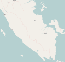
In 2012, the new regency comprised eight districts (kecamatan), which until 2012 were part of the West Lampung Regency. However, since 2012, three additional districts have been created in the northern half of the new regency from parts of the existing districts - Krui Selatan (South Krui), Pulau Pisang (Pisang Island), and Way Krui. Below is a list (from northwest to southeast) of these districts, along with their areas and populations at the 2010 Census[3] and the 2020 Census,[4] as well as the official estimates as of mid-2024.[1] The table also indicates the locations of the district administrative centers, the number of villages in each district (a total of 116 rural desa and two urban kelurahan - both of the latter in Pesisir Tengah District), and their postcodes.
Notes: (a) The 2010 population of the new Pulau Pisang District is included in the figure for Pesisir Utara District. The new Pulau Pisang District comprises the offshore island of the same name, adjacent to the coast of Karya Penggawa District. (b) The 2010 populations of the new Way Krui District and Krui Selatan District are included in the figure for Pesisir Tengah District. (c) Including the two kelurahan of Pasar Kota Krui and Pasar Krui.
History
Umpu Ratu Selalau Sanghyang Sangun Gukhu, born on the 21st of Ramadhan 828 Hijri (equivalent to the 9th of April 1425 AD) and died in 962 Hijri, was a prominent figure as a Mujahid Spreader of Islam and the Sultan of Kepaksian Pernong Sekala Brak, residing in the Istana Gedung Dalom Batu Brak.[5]
Queen Umpu Selalau Shangyang Sangun Gukhu was laid to rest in the Tambak Bata cemetery. An evidence of her legacy in Krui Pesisir Barat Regency is the footprint engraved on a stone called Maqom Selalau. This stone marks the location where she convened and vanquished the ruler of Bunian Matu. Maqom Selalau has since served as a significant landmark in the region, stretching from the sugarcane fields along the Limau River Kingdom to the Kepaksian Nyerupa area. It extends from Maqom to Suwoh, Tanggamus Regency, Lampung Selatan Regency, and Batu Brak, which encompasses the area of Kepaksian Pernong Sekala Brak.[6]
Pesisir Barat Regency was formally established in 2012 under the Republic of Indonesia Law Number 22 of 2012 regarding the Establishment of the West Coastal Regency in Lampung Province (State Gazette of the Republic of Indonesia 2012 Number 231 Supplement to State Gazette Number 5364).[7]
Prior to the establishment of the West Coastal Regency as stipulated in the aforementioned law, it was part of the West Lampung Regency administered from Liwa.[7]
Airport
In early October 2011, the runway test was conducted, and the testers concluded that the airport was ready for operation. Spanning 50 hectares of land, the airport features a 974-meter-long runway, an apron, taxiway, an administration building, and a 1,800-meter road leading to the airport. Situated in Seray village, Pesisir Tengah district, it aims to bolster tourism and serve as a precautionary measure in cases of natural disasters.[8]
Dolphin conservation
According to traditional wisdom, which prohibits people from catching dolphins, hundreds of these marine mammals encircle Betuah Island and Banana Island, with their numbers showing a tendency to increase each year.[9]
Tanjung Setia Beach
Tanjung Setia Beach, situated facing the Indian Ocean, lies 273 kilometers from Bandar Lampung, requiring approximately 6 to 7 hours by car to reach. From June to August annually, the waves reach heights of 6 to 7 meters, extending over 200 meters, making it an ideal destination for surfers worldwide, earning comparisons to Hawaii. Just a few kilometers off the coast, Indo-Pacific blue marlins weighing up to 70 kilograms (170 centimeters) can be found.[10]
References
1 2 3 Badan Pusat Statistik, Jakarta, 28 February 2025, Kabupaten Pesisir Barat Dalam Angka 2025 (Katalog-BPS 1102001.1813)
This page is based on this Wikipedia article Text is available under the CC BY-SA 4.0 license; additional terms may apply. Images, videos and audio are available under their respective licenses.