Castle Air Force Base is a former United States Air Force Strategic Air Command base in California, northeast of Atwater, northwest of Merced, and about 115 miles (185 km) south of Sacramento.
Hemet-Ryan Airport is three miles (6 km) southwest of Hemet, in Riverside County, California.

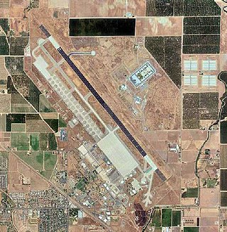
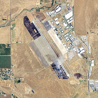
Turlock Municipal Airport is a public airport located eight miles (13 km) east of Turlock, in Merced County, California, United States. This general aviation airport covers 320 acres (129 ha) and has one runway. It was purposed during World War II to train pilots for air combat.

Wasco Airport, also known as Wasco-Kern County Airport, is a public airport located two miles (3.2 km) northwest of Wasco, serving Kern County, California, USA. This general aviation airport covers 158 acres (64 ha) and has one runway.
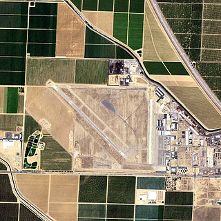
Shafter Airport, also known as Minter Field and formerly known as Air Corps Basic Flying School, is a public use airport located four nautical miles east of the central business district of Shafter and 14 miles northwest of Bakersfield, a city in Kern County, California, United States. Originally a World War II primary training facility for pilots, it is currently a public airport owned by the Minter Field Airport District. This airport is included in the National Plan of Integrated Airport Systems for 2011–2015, which categorized it as a general aviation facility.

Avon Park Executive Airport is a city-owned, public-use airport located two nautical miles (3.7 km) west of the central business district of Avon Park, a city in Highlands County, Florida, United States.
During World War II, the United States Army Air Forces (USAAF) established numerous airfields in California for training pilots and aircrews of USAAF fighters and bombers.

Lemoore Army Air Field, located nine miles (14 km) southwest of Lemoore, California, was a dirt air field usable only in dry weather. It nevertheless was used by the AAF Western Flying Training Command as a processing and training field.

Eagle Field is a privately owned, private use airport in Fresno County, California, United States. It is located seven nautical miles southwest of the central business district of Dos Palos, a city in neighboring Merced County.

Rankin Field is a former airport and military airfield located approximately 7 miles (11 km) southeast of Tulare, California. It was a United States Army Air Forces basic flying training facility during World War II. It is now an agricultural and light industrial site.

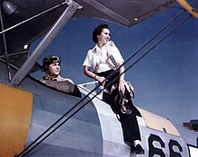
California during World War II was a major contributor to the World War II effort. California's long Pacific Ocean coastline provided the support needed for the Pacific War. California also supported the war in Europe. After the Japanese attack on Pearl Harbor on December 7, 1941, most of California's manufacturing was shifted to the war effort. California became a major ship builder and aircraft manufacturer. Existing military installations were enlarged and many new ones were built. California trained many of the troops before their oversea deployment. Over 800,000 Californians served in the United States Armed Forces. California agriculture, ranches and farms were used to feed the troops around the world. California's long coastline also put the state in fear, as an attack on California seemed likely. California was used for the temporary and permanent internment camps for Japanese Americans. The population grew significantly, largely due to servicemen who were stationed at the new military bases/training facilities and the mass influx of workers from around the U.S. in the growing defense industries. With all the new economy activity, California was lifted out of the Great Depression. Over 500,000 people moved to California from other states to work in the growing economy. California expanded its oil and mineral production to keep up with the war demand.

Helm Field also called Lemoore Auxiliary Army Airfield A-7 is a former US Army Airfield use for training during World War II. Helm Field was location in the town of Coalinga, California, 70 miles south of Fresno. Helm Field had two 3,000 foot runways, one oriented east/west and one oriented northwest–southeast. The Airfield was on a 773 acres site of form farm land. The US Army purchased the land on January 11, 1943 for training pilots. The Airfield was used by the Lemoore Basic Flying School, based at the Lemoore Army Air Field. Helm Field was 15 miles northwest of Lemoore Army Air Field. The Army built at Helm Field to support training stage house, control tower, motor pool building, crash truck shelter and latrines. Helm Field was used by Air Corps Basic Flying School, the AAF Basic Flying School, the AAF Pilot School, the 88th Air Base Squadron, the 3023rd Army Air Force Pilot School and the 461st Army Air Force Base Unit. The army closed Helm Field on October 15, 1844 and the Airfield was sold by the War Assets Administration. Helm Field was used as a farm labor camp in the 1950s. The east–west runway was returned to farmland. The northwest–southeast runway was still intact and was used as a civilian airfield till 1971.
Chico Army Airfield auxiliary fields were a number of airfields used during World War II to support the Chico Army Airfield. On September 11, 1941, the US Army rented from the City of Chico a small 1930's airport that sat on 160 acres (0.65 km2) of land. The Airfield was five miles (8.0 km) north of the city center. The Army built up the small airport into the Chico Army Airfield. From the Chico Army Airfield operated the: United States Army Air Corps's Army Air Forces Basic Flying School, the Army Air Force Pilot School, the 10th Base Headquarters an Air Base Squadron and the 433rd Army Air Force Base Unit or Combat Crew Training Station of Fighter. To support the training of the many pilots, Chico Army Airfield operated a number of auxiliary airfields. Some auxiliary fields were no more than a landing strip runway, others were other operation airfield that supported the training at the Chico Army Airfield.

Gardner Army Airfield auxiliary fields were a number of airfields used during World War II to support the Gardner Army Airfield. May 12, 1943 the US Army leased 1,396.36 acres for Gardner Field, located 9 miles southeast of Taft, California. Gardner Army Airfield was named after Major John H. Gardner, a World War I aviator hero. The Army built three runways to support training activities need for World War II. From Gardner Army Airfield the United States Army Air Corps's Western Flying Training Command started training the needed pilots. To support the training of the many pilots, Gardner Army Airfield operated a number of auxiliary airfields. Some auxiliary fields were no more than a landing strip, others were other operation airfield that supported the training at the Gardner Army Airfield. The Vultee BT-13 Valiant and Boeing-Stearman Model 75 were the most common planes used for training at Gardner Army Airfields, but large bombers were trained also. Gardner Army Airfield auxiliary fields were:
Minter Army Airfield auxiliary fields were a number of airfields used during World War II to support the Minter Army Airfield near Shafter, California. Minter Army Airfield was also called Lerdo Field, after the nearby road. Minter Army Airfield also housed the Shafter Gap Filler Annex P-59A and Shafter Army Aviation Test Activity and opened in June 1941. An Army depot open on the base in October 1941, the Minter Sub-Depot, a division of the Sacramento Air Depot. Minter Army Airfield had 7,000 troops and civilians working at the base.
Victorville Army Airfield auxiliary fields were four airfields used during World War II to support the Victorville Army Airfield pilot training near Victorville, California, and Adelanto, California. After the war the Victorville Army Airfield was renamed George Air Force Base on January 13, 1948. The airfields were built in 1941 by the United States Army Air Corps just before the war. Victorville Army Airfield covered 2,200-acre in the Mojave Desert. The US Army held a groundbreaking ceremony on 12 July 1941. The base, called Victorville Army Flying School, was ready to use before the attack on Pearl Harbor on December 7, 1941. The Army built four runways in a triangle configuration, with one runway down the middle of the triangle. Seven hangars were built to support operation. On April 23, 1943, the base was renamed Victorville Army Airfield.
Condor Field was an airbase located in Twentynine Palms, California used for training both in World War II and the Korean War. From 1939 to 1942, and from 1945 to 1949, it was operated as a civil airport. The now-abandoned airfield is on the Marine Corps Air Ground Combat Center Twentynine Palms. In about 1939, a 3,000-foot runway was built at the southeast edge of dry lake Mesquite Lake as a civil field and named Twenty Nine Palms Airfield.

Naval Air Station Livermore has nearby airfield landing strips to support the training of US Navy pilots during World War 2. The airfield are called Naval Outlying Landing Field (NOLFs). For the war many new trained pilots were needed. The Naval Outlying Landing Fields provided a place for pilots to practice landing and take off without other air traffic. The remotes sites offered flight training without distractions. Most of the new pilots departed to the Pacific War after training. The Outlying Landing Fields had little or no support facilities. Naval Air Station Livermore opened in 1942 and closed in 1951. The Outlying field closed in 1945, having completed the role of training over 4000 new pilots. To open the needed Outlying Landing Fields quickly, the Navy took over local crop dusting and barnstorming airfields.

Naval Air Station Los Alamitos Naval Outlying Landing Fields were a set airfield near Naval Air Station Los Alamitos to support the training of US Navy pilots during World War 2. The support airfields are called Naval Outlying Landing Field (NOLF). For the war, many new trained pilots were needed. The Naval Outlying Landing Fields provided a place for pilots to practice landing and take off without other air traffic. The remotes sites offered flight training without distractions. Most of the new pilots departed to the Pacific War after training. The Outlying Landing Fields had little or no support facilities. Naval Air Station Los Alamitos opened in 1942 and was transferred to the US Army in 1977 as Los Alamitos Army Airfield. Most of the Outlying fields closed in 1945, having completed the role of training new pilots. To open the needed Outlying Landing Fields quickly, the Navy took over local crop dusting and barnstorming airfields. Naval Air Station Los Alamitos was also called Los Alamitos Naval Reserve Air Base. During the war Marine Corps Air Station El Toro also used the outlying Landing Field. The Timm N2T Tutor was the most common plane used for training on the outlying landing fields.

Peik Auxiliary Field also called Peik Field and Peik Airport was an airfield used during World War II to support the San Bernardino Army Air Field, Desert Training Center and San Diego Municipal Airport, called Lindbergh Field. The local Peik Airport was built in 1934 by Arnold Peik, his son Leander Peik (1927-2011) and his family, barnstormers from Wisconsin, that also ran a flight school at the airport. Leander Peik dad taught him to fly when he was 10 years old, he became the airport manager at a young age. With the start of World War II there was a demand for trained pilots and the Army took over the Airport. Auxiliary fields, like Peik, were used to support the training of US Army pilots during World War II. The runway was located in Mission Bay of San Diego, California. The runways as in the southeast corner of Mission Bay, near the current Interstate 5 and Interstate 8 interchange. The entrance to the Peik Auxiliary Field was at the end of Anna Avenue, which at the time extended into Mission Bay. When the I-5 was built Anna Avenue was removed west of the Santa Fe train tracks. For the war, many new trained pilots were needed. Peik Auxiliary Field provided a place for pilots to practice landing and take off without other air traffic. Peik Auxiliary Field site offered flight training without distractions. The United States Army Air Corps's Army Air Forces Basic Flying School, the Army Air Force Pilot School used Peik Auxiliary Field for fighter pilots training. The Army took the runway from 800-feet to 2,600-feet long and 150-feet wide made of turfgrass. To support the training of the many pilots, San Bernardino Army Air Field operated a number of auxiliary airfields. After the war, Peik Auxiliary Field was returned to the Peik family. The Peik family closed the airport in 1955 and no trace of the runway can be found today, the site is open land in Mission Bay with Sea World Drive cutting across the past runway.