Minter Army Airfield auxiliary fields were a number of airfields used during World War II to support the Minter Army Airfield (now the Shafter Airport) near Shafter, California. Minter Army Airfield was also called Lerdo Field, after the nearby road. Minter Army Airfield also housed the Shafter Gap Filler Annex P-59A and Shafter Army Aviation Test Activity and opened in June 1941. An Army depot open on the base in October 1941, the Minter Sub-Depot, a division of the Sacramento Air Depot. Minter Army Airfield had 7,000 troops and civilians working at the base.
Minter Army Airfield was named after First Lieutenant Hugh C. Minter, a World War I veteran killed in a mid-air collision at March Field in July 1932. The Army built three 4,500-foot runways on the 1,466-acre site, to support training activities need for World War II. Also at Airfield were built three square landing mat. The From Minter Army Airfield the United States Army Air Corps's Western Flying Training Command started training the needed pilots. To support the training of the many pilots, Minter Army Airfield operated a number of auxiliary airfields. Some auxiliary fields were no more than a landing strip, others were other operation airfield that supported the training at the Minter Army Airfield. The Vultee BT-13 Valiant and Boeing-Stearman Model 75 were the most common plane used for training at Minter Army Airfields, but large bombers were trained also. Minter Army Airfield auxiliary fields were:[1]
Wasco Auxiliary Field or Wasco Field No. 1 was a satellite airfield of Minter Field, 1.5 miles north the town of Wasco, California, at 35°37′11″N119°21′13″W / 35.61972°N 119.35361°W / 35.61972; -119.35361 (Wasco Auxiliary Airfield) at an elevation of 313ft (95m). The US Army leased the small 40-acre Wasco Airport and 120 acres north of the airport from Kern County on June 16, 1941. Minter Field was 12 miles to the southeast of Wasco Field. The Army built a five-runway landing mat on the site, with no other improvements. In 1944 Pond Field was closed and the lease ended on June 30, 1951. The Wasco Auxiliary Field is now the Wasco-Kern County Airport a single runway on a public airport.[2][3]
Pond Auxiliary Field
Pond Auxiliary Field or Pond Field No. 2 or was a satellite airfield of Minter Field, just south/west of the town of Pond, California, at 35°42′36″N119°20′59″W / 35.71000°N 119.34972°W / 35.71000; -119.34972 (Pond Auxiliary Airfield). The US Army leased 158 acres from Kern County on June 16, 1941. Minter Field was 16 miles southeast of Pond Field. The Army built a 5 runway landing mat on the site, with no other improvements. On August 8, 1942, Stewart Smith was killed while approaching Pond Field, he was with the 525th School Squadron, his plane stalled 6 miles west of Pond Field on. In May 1944 Pond Field was closed and the lease ended. Pond Field was located at what is now northeast of the intersection of Peterson Road & Magnolia Avenue, in Pond, California. There is no trace of the airfield and the land is now used for agriculture.[4][5]
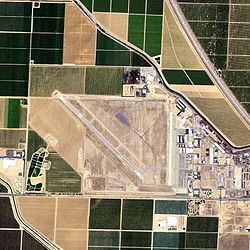
Famoso Auxiliary Field
Famoso Auxiliary Field in 1944
Famoso Auxiliary Field or Minter Auxiliary Field No. 3' was a satellite airfield of Minter Field for flight training. Famoso Auxiliary Field was located 2 miles north of Famoso, California, and 24 miles north-northwest of Bakersfield in Kern County at 35°38′20″N119°12′35″W / 35.63889°N 119.20972°W / 35.63889; -119.20972 (Famoso Auxiliary Airfield). The US Army acquired 500 acres from County of Kern on July 1, 1941. Minter Field / Lerdo Field is 9 miles to the south of Famoso Auxiliary Field. The Army built a 3,000 × 3,000-foot landing area, three buildings: Stage House, Crash Truck Shelter and Latrine. Pilot Leroy McDonald was killed in an A BT-13 trainer crash at Famoso Field on April 22, 1942, on plane serial no. 41–10699. After the war, Famoso Auxiliary Field was closed and there is no trace of the former landing mat. Famoso Auxiliary Field was at what is now east of Highway 99 and south of Whistler Road.[6][7]
Dunlap Auxiliary Field
Dunlap Auxiliary Field in 19434
Dunlap Auxiliary Field also called Minter Field Auxiliary Field No. 4 and Jasmin Field was a satellite airfield of Minter Field. Located in Jasmin, California in Kern County at 35°44′05″N119°07′00″W / 35.73472°N 119.11667°W / 35.73472; -119.11667 (Dunlap Auxiliary Airfield). Dunlap Auxiliary Field was 19 miles north-northeast of Minter Field at an elevation of 530 feet. Dunlap Auxiliary Field was open in 1941 on a 210.22 acres site and used to train World War II pilots in landing and take off. The site was also used as emergency landing airfield. The runway was a square mat 2,640 feet by 2640 feet. The mat was used for Boeing-Stearman Model 75 trainer bi-planes. No improvements were built at the airfield. There were two crash accidents at Dunlap Field, a BT-13 trainer crash-landed on April 8, 1942, the planes serial no. was 41–9665, piloted by William Raabe. A North American T-6 Texan AT-6C trainer crashed at Dunlap Field on July 23, 1945, it was serial no. 42–3911, piloted by Kay Nelson. After the war the field was closed on 8 October 1946 and no trace of the airfield can be seen today. The Dunlap Auxiliary Field was located at the present-day site of (north of) Hart Avenue and between Kyte Avenue and Quality Road, one mile east of Jasmin in a vineyard of Pandol and Sons. The site is between California State Route 99 and California State Route 65.[8][9]
Semitropic Auxiliary Field
Semitropic Auxiliary Field Landing Mat in 1944
Semitropic Auxiliary Field or Semitropic Auxiliary Field No. 5 was a satellite airfield of Minter Field for flight training. Semitropic Auxiliary Field was 7 miles northwest of Minter Field. Semitropic Auxiliary Field was located 8 miles west of Wasco, California at 35°45′25″N119°29′05″W / 35.75694°N 119.48472°W / 35.75694; -119.48472 (Semi-tropic Auxiliary Airfield) in Kern County at an elevation of 265 feet. In 1942 the US Army acquired 600 acres of land for the runway from 11 landowners. The Army built: crash truck shelter, stage house, latrines, 3,000 by 3,000-foot landing mat and a runway. One crash happened one mile north of the runway on October 24, 1943, Otto Piepnbrink was killed in a BT-13A trainer, he was with the 324th Basic Flight Training Squadron. At the end of the war the land was sold on November 20, 1946. There is no trace of the airfield and the land is now used for agriculture by three owners. [10][11]
Manning, Thomas A. (2005), History of Air Education and Training Command, 1942–2002. Office of History and Research, Headquarters, AETC, Randolph AFB, Texas OCLC71006954, 29991467
Shaw, Frederick J. (2004), Locating Air Force Base Sites, History's Legacy, Air Force History and Museums Program, United States Air Force, Washington DC. OCLC57007862, 1050653629
This page is based on this Wikipedia article Text is available under the CC BY-SA 4.0 license; additional terms may apply. Images, videos and audio are available under their respective licenses.