Meredith, Kentucky

Last updated
Meredith
USA Kentucky location map.svg
Red pog.svg
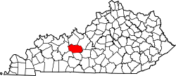
Meredith
Location within the state of Kentucky
Usa edcp location map.svg
Red pog.svg
Meredith
Meredith (the United States)
Coordinates: 37°24′9.19″N86°14′12.9″W / 37.4025528°N 86.236917°W / 37.4025528; -86.236917
CountryUnited States
State Kentucky
County Grayson
Elevation
820 ft (250 m)
Time zone UTC-6 (Central (CST))
  Summer (DST) UTC-5 (CDT)
GNIS feature ID508591 [1]

Meredith is an unincorporated community located in central Grayson County, Kentucky, United States. [1]

Geography

Meredith is located about 5 miles (8.0 km) south-southeast of Leitchfield. The community is situated along Kentucky Route 259 (KY 259) at its junction with KY 226. [2]

Related Research Articles

<span class="mw-page-title-main">Kentucky Route 90</span> State highway in Kentucky, USA

Kentucky Route 90 is a major east–west state highway in southern Kentucky. The route is 134.734 miles (216.833 km) long, and it traverses Barren, Metcalfe, Cumberland, Clinton, Wayne, Pulaski, McCreary and Whitley Counties in southern Kentucky. It runs from the KY 70 junction near Interstate 65 in Cave City to US 25W about 8 miles (13 km) from Interstate 75.

<span class="mw-page-title-main">Kentucky Route 70</span> State highway in Kentucky, United States

Kentucky Route 70 (KY 70) is a long east-east state highway that originates at a junction with U.S. Route 60 (US 60) in Smithland in Livingston County, just east of the Ohio River. The route continues through the counties of Crittenden, Caldwell, Hopkins, Muhlenberg, Butler, Edmonson, Barren, Barren, Metcalfe, Green, Taylor, Casey, Pulaski, Lincoln and back into Pulaski again to terminate at a junction with US 150 near Maretburg in Rockcastle.

<span class="mw-page-title-main">Kentucky Route 259</span> State highway in Kentucky, United States

Kentucky Route 259 is a 95.91-mile-long (154.35 km) state highway that traverses five counties in west-central Kentucky.

<span class="mw-page-title-main">Kentucky Route 185</span> State highway in Kentucky

Kentucky Route 185 is a north–south state highway traversing four counties in west-central Kentucky.

Pig is an unincorporated community in southern Edmonson County, Kentucky, United States.

Straw is an unincorporated community located in Edmonson County, Kentucky, United States.

Temple Hill is an unincorporated community in Barren County, Kentucky, in the United States.

Wax is an unincorporated community in Grayson County, Kentucky, United States.

<span class="mw-page-title-main">Snow, Kentucky</span> Unincorporated community in Kentucky, United States

Snow is an unincorporated community within Clinton County, Kentucky, United States.

Welcome is an unincorporated community located in Butler County, Kentucky, United States.

<span class="mw-page-title-main">Kentucky Route 106</span> State highway in Kentucky, United States

Kentucky Route 106 (KY 106) is a 35-mile-long (56 km) east-west state highway traversing three counties in west-central Kentucky.

Roundhill is an unincorporated community in Butler County, Kentucky, United States, situated on Butler County's eastern boundary with Edmonson County.

<span class="mw-page-title-main">Kentucky Route 3155</span>

Kentucky Route 3155 (KY 3155), also known as the William Thomason Byway, or known locally as the Leitchfield Bypass, is a 4.697-mile-long (7.559 km) state route located entirely in central Grayson County in north-central Kentucky. Both of this road's termini are intersections with KY 259 on the north and south sides of Leitchfield as it is a partial beltway around the city.

<span class="mw-page-title-main">Kentucky Route 261</span>

Kentucky Route 261 (KY 261) is a 42.605-mile-long (68.566 km) state highway in Kentucky that runs from Kentucky Route 54 southeast of Fordsville to Kentucky Route 79 and Sandy Hill Road in rural Meade County southwest of Brandenburg via McQuady, Hardinsburg, and Webster.

<span class="mw-page-title-main">Kentucky Route 226</span>

Kentucky Route 226 is a 1.303-mile-long (2.097 km) rural, secondary state highway located entirely in Grayson County, Kentucky.

Millerstown is an unincorporated community in Grayson County, Kentucky, in the United States.

Kyrock is a ghost town in Edmonson County in south central Kentucky, United States. The ghost town is located about 2.4 miles (3.9 km) east of Sweeden, or about 5 miles (8.0 km) north-northeast of the county seat of Brownsville. It was once a referred to as a “company town” along the Nolin River during much of the first half of the 20th century, but the industrial town was disincorporated in 1966, about nine years after the closure of the company that created the town.

Highland Springs is an unincorporated community in northwest Barren County, Kentucky, United States.

Logansport is an unincorporated community in northwestern Butler County in south-central Kentucky, United States. Logansport is part of the Bowling Green Metropolitan Statistical Area.

Northtown is an unincorporated community in Hart County, Kentucky, United States. The elevation of Northtown is 837 feet. It appears on the Mammoth Cave U.S. Geological Survey Map and is in the Central Time Zone.

References

  1. 1 2 U.S. Geological Survey Geographic Names Information System: Meredith, Kentucky
  2. DeLorme (2010). Kentucky Atlas and Gazetteer (Map). Yarmouth, Maine: DeLorme. p. 64. § A5. ISBN   0-89933-340-0.