Jackson County is a county located in the U.S. state of Mississippi. As of the 2020 census, the population was 143,252, making it the fifth-most populous county in Mississippi. Its county seat is Pascagoula. The county was named for Andrew Jackson, general in the United States Army and afterward President of the United States.

George County is a county located in the U.S. state of Mississippi. As of the 2020 census, the population was 24,350. Its county seat is Lucedale. The county is named for James Z. George, US Senator from Mississippi.

Clarke County is a county located in the U.S. state of Mississippi. As of the 2020 census, the population was 15,615. Its county seat is Quitman. Clarke County is named for Joshua G. Clarke, the first Mississippi state chancellor and judge.
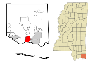
Lucedale is a city in George County, Mississippi, United States. It is part of the Pascagoula, Mississippi Metropolitan Statistical Area. Lucedale was founded in 1901 when Governor A.H. Longino signed his name and his seal to the proclamation. It was named after its founder, Gregory Marston Luce, who operated a lumber business there. The population was 2,923 at the 2010 census, up from 2,458 at the 2000 census. It is the county seat of George County.
Gautier is a city in Jackson County, Mississippi, United States, along the Gulf of Mexico west of Pascagoula. It is part of the Pascagoula Metropolitan Statistical Area. The population was 18,572 at the 2010 census, up from 11,681 at the 2000 census. In 2002, Gautier had annexed land more than doubling its area.

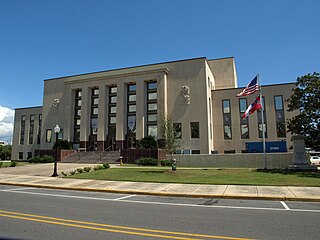
Pascagoula is a city in Jackson County, Mississippi, United States. It is the principal city of the Pascagoula metropolitan area, and is part of the Gulfport–Biloxi–Pascagoula Combined Statistical Area and the Gulfport-Biloxi metropolitan area. The population was 22,392 at the 2010 census, down from 26,200 at the 2000 census. As of 2019 the estimated population was 21,699. It is the county seat of Jackson County.

The Gulf Intracoastal Waterway is the portion of the Intracoastal Waterway located along the Gulf Coast of the United States. It is a navigable inland waterway running approximately 1,050 mi (1,690 km) from Carrabelle, Florida, to Brownsville, Texas.

Naval Station Pascagoula was a base of the United States Navy, in Pascagoula, Mississippi. The base officially closed 15 November 2006. The base's property, on Singing River Island in the Mississippi Sound at the mouth of the Pascagoula River, was formally transferred to the Mississippi Secretary of State's office 9 July 2007.

The Mississippi Gulf Coast, also known as Mississippi Coast, Mississippi Gulf Coast region, Coastal Mississippi, and The Coast, is the area of Mississippi along the Mississippi Sound at the northern extreme of the Gulf of Mexico.

The Pascagoula River is a river, about 80 miles (130 km) long, in southeastern Mississippi in the United States. The river drains an area of about 8,800 square miles (23,000 km²) and flows into Mississippi Sound of the Gulf of Mexico. The Pascagoula River Basin is managed by the Pat Harrison Waterway District.

The Chickasawhay River is a river, about 210 miles (340 km) long, in southeastern Mississippi in the United States. It is a principal tributary of the Pascagoula River, which flows to the Gulf of Mexico. The Chickasawhay's tributaries also drain a portion of western Alabama. The name "Chickasawhay" comes from the Choctaw word chikashsha-ahi, literally "Chickasaw potato".

The Leaf River is a river, about 180 mi (290 km) long, in southern Mississippi in the United States. It is a principal tributary of the Pascagoula River, which flows to the Gulf of Mexico.
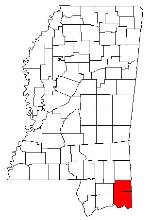
The Pascagoula Metropolitan Statistical Area is a metropolitan area in the southeastern corner of Mississippi that covers two counties - Jackson and George. As of the 2000 census, the MSA had a population of 150,564. The area was significantly impacted by Hurricane Katrina in 2005. A July 1, 2009 estimate placed the population at 155,603. Prior to the hurricane, the area had experienced steady population growth. It is also part of the larger Gulfport-Biloxi-Pascagoula Combined Statistical Area.

Interstate 10 (I-10), a major east–west Interstate Highway in the southern areas of the United States, has a section of about 77 miles (124 km) in Mississippi.
The Pascagoula-Gautier School District is a public school system based in Pascagoula, Mississippi.

Pascagoula station is a closed intercity train station in Pascagoula, Mississippi, United States. It originally the served the Louisville and Nashville Railroad but was most recently a stop for Amtrak. The station is on the National Register of Historic Places as the Louisville and Nashville Railroad Depot, and was designated a Mississippi Landmark by the Mississippi Department of Archives and History. In addition, the station serves as an art gallery owned by the Singing River Art Association.
Benndale is a census-designated place (CDP) and unincorporated community in George County, Mississippi, near the intersection of State Highways 26 and 57. It is part of the Pascagoula Metropolitan Statistical Area. Prior to the creation of George County, Benndale was located in Jackson County. It became a CDP in the 2020 United States census, with a population of 65.

Pat Harrison Waterway District (PHWD) is a Mississippi State Agency with headquarters in Hattiesburg. The agency was created in 1962 with a directive of flood control in southeastern and east central Mississippi.

Red Creek is a tributary of the Pascagoula River in the U.S. state of Mississippi. The creek derives its name from naturally occurring tannins that give the water a reddish appearance as it flows over the white sand bottom. A portion of Red Creek has been designated a State Scenic Stream by the Mississippi Legislature.


