Basin, Mississippi | |
|---|---|
 Basin  Basin | |
| Coordinates: 30°48′11″N88°39′46″W / 30.80306°N 88.66278°W | |
| Country | United States |
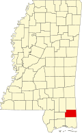
| State | Mississippi |
| County | George |
| Elevation | 141 ft (43 m) |
| Time zone | UTC-6 (Central (CST)) |
| • Summer (DST) | UTC-5 (CDT) |
| GNIS feature ID | 666556 [1] |
Basin (originally Helveston) is an unincorporated community in George County, Mississippi, United States. [1] Prior to the creation of George County, Basin was located in Jackson County. [2]
A post office operated under the name Basin from 1887 to 1922. [3]
The Basin soil series is named for the community. [4]