Benndale, Mississippi | |
|---|---|
 Benndale  Benndale | |
| Coordinates: 30°52′18″N88°48′25″W / 30.87167°N 88.80694°W | |
| Country | United States |
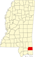
| State | Mississippi |
| County | George |
| Area | |
• Total | 1.51 sq mi (3.91 km2) |
| • Land | 1.51 sq mi (3.91 km2) |
| • Water | 0.00 sq mi (0.00 km2) |
| Population (2020) | |
• Total | 65 |
| • Density | 43.07/sq mi (16.63/km2) |
| Time zone | UTC-6 (Central (CST)) |
| • Summer (DST) | UTC-5 (CDT) |
| FIPS code | 28-05180 |
| GNIS feature ID | 691696 [2] |
Benndale is a census-designated place (CDP) and unincorporated community in George County, Mississippi, near the intersection of State Highways 26 (MS 26) and 57 (MS 57). It is part of the Pascagoula Metropolitan Statistical Area. Prior to the creation of George County, Benndale was located in Jackson County. [3] It became a CDP in the 2020 United States census, with a population of 65. [4]