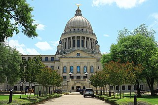
Jackson is the capital of and the most populous city in the U.S. state of Mississippi. The city is also one of two county seats of Hinds County, along with Raymond. The city had a population of 153,701 at the 2020 census, down from 173,514 at the 2010 census. Jackson's population declined more between 2010 and 2020 (11.42%) than any major city in the United States. Jackson is the anchor for the Jackson metropolitan statistical area, the largest metropolitan area completely within the state and the 10th largest urban area in the Deep South. With a 2020 population estimated around 600,000, metropolitan Jackson is home to over one-fifth of Mississippi's population. The city sits on the Pearl River and is located in the greater Jackson Prairie region of Mississippi.

Stone County is a county located in the U.S. state of Mississippi. As of the 2020 census, the population was 18,333. Its county seat is Wiggins. Stone County was formed from the northern portion of Harrison County on June 5, 1916. The county was named for John M. Stone, who served as Governor of Mississippi from 1876 to 1882 and again from 1890 to 1896.
Perry County is a county located in the U.S. state of Mississippi. As of the 2020 census, the population was 11,511. The county seat is New Augusta. The county is named after the War of 1812 naval hero, Oliver Hazard Perry.
Pearl River County is a county located in the U.S. state of Mississippi. The population was 56,145 at the 2020 census. Its county seat is Poplarville.
Lawrence County is a county located in the U.S. state of Mississippi. As of the 2020 census, the population was 12,016. Its county seat is Monticello. The county is named for the naval hero James Lawrence.

Jefferson County is a county located in the U.S. state of Mississippi; its western border is formed by the Mississippi River. As of the 2020 census, the population was 7,260, making it the fourth-least populous county in Mississippi. Its county seat is Fayette. The county is named for U.S. President Thomas Jefferson.
Jackson County is a county located in the U.S. state of Mississippi. As of the 2020 census, the population was 143,252, making it the fifth-most populous county in Mississippi. Its county seat is Pascagoula. The county was named for Andrew Jackson, general in the United States Army and afterward President of the United States.

Itawamba County is a county located in the U.S. state of Mississippi. As of the 2020 United States Census, the population was 23,863. Its county seat is Fulton. The county is part of the Tupelo, MS Micropolitan Statistical Area.
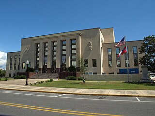
Hinds County is a county located in the U.S. state of Mississippi. With its county seats, Hinds is the most populous county in Mississippi with a 2020 census population of 227,742 residents. Hinds County is a central part of the Jackson metropolitan statistical area. It is a professional, educational, business and industrial hub in the state. It is bordered on the northwest by the Big Black River and on the east by the Pearl River. It is one county width away from the Yazoo River and the southern border of the Mississippi Delta.

George County is a county located in the U.S. state of Mississippi. As of the 2020 census, the population was 24,350. Its county seat is Lucedale. The county is named for James Z. George, US Senator from Mississippi.
Forrest County is located in the U.S. state of Mississippi. As of the 2020 census, the population was 78,158. Its county seat and largest city is Hattiesburg. The county was created from Perry County in 1908 and named in honor of Nathan Bedford Forrest, a Confederate general in the American Civil War and the first Grand Wizard of the Ku Klux Klan. Forrest County is part of the Hattiesburg, MS Metropolitan Statistical Area.

Camp Springs is an unincorporated area and census-designated place (CDP) in Prince George's County, Maryland, United States. The population was 22,734 at the 2020 census. Camp Springs is not an official post office designation; the area is divided among the surrounding mailing addresses of Temple Hills, Fort Washington, Clinton, and Suitland.

Hazlehurst is a city in and the county seat of Copiah County, Mississippi, United States, located about 30 miles (48 km) south of the state capital Jackson along Interstate 55. The population was 4,009 at the 2010 census. It is part of the Jackson Metropolitan Statistical Area. Its economy is based on agriculture, particularly tomatoes and cabbage.

Olive Branch is a city in DeSoto County, Mississippi, United States. As of the 2020 census, the population is 39,711. Olive Branch is part of the Memphis Metropolitan Statistical Area, a region that consists of three counties in southwest Tennessee, five counties in northwest Mississippi, and two counties in eastern Arkansas. Olive Branch was the fastest growing city in the United States, with a growth rate of 838% as of 2010 in a thirty year time frame. Along with other rapidly growing places in DeSoto County, Olive Branch attributes most of its growth and development to the exodus of large numbers of families from central Memphis.
Lucedale is a city in George County, Mississippi, United States. It is part of the Pascagoula, Mississippi Metropolitan Statistical Area. Lucedale was founded in 1901 when Governor A.H. Longino signed his name and his seal to the proclamation. It was named after its founder, Gregory Marston Luce, who operated a lumber business there. The population was 2,923 at the 2010 census, up from 2,458 at the 2000 census. It is the county seat of George County.
Darracott is an unincorporated community in Monroe County, Mississippi.
Independence is a census-designated place and unincorporated community in Tate County, Mississippi, United States.
Dabney Crossroads is an unincorporated community in Hinds County, Mississippi, United States. Dabney Crossroads is 8 miles (13 km) west of Terry and is a part of the Jackson Metropolitan Statistical Area..

Toomsuba is a census-designated place (CDP) and unincorporated community in Lauderdale County, Mississippi, United States. Its population was 778 as of the 2020 census. Its ZIP code is 39364.
Bounds Crossroads is a small unincorporated community in Itawamba County, Mississippi between Tremont, Mississippi and Red Bay, Alabama on Mississippi Highway 23. Tammy Wynette grew up in the area and attended Tremont Attendance Center in Tremont where she played basketball, sang, and was named Miss THS. Mississippi Highway 23 intersects Mt. Gilead Road and Hartsell Road in Bounds Crossroads. The area's zip code is 38876. Briar Creek runs through the hilly area of eastern Itawamba County. A small graveyard is in the area. The nearby Red Bay Museum in Red Bay, Alabama has a collection related to Wynette.


