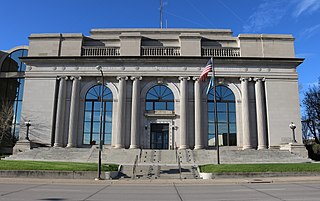
Pennington County is a county in the U.S. state of South Dakota. As of the 2020 census, the population was 109,222, making it the second most populous county in South Dakota. Its county seat is Rapid City. The county was created in 1875, and was organized in 1877. It is named for John L. Pennington, fifth Governor of Dakota Territory, who held office in 1875 when the county was formed.

Silver City is an unincorporated community in Pennington County, South Dakota, United States, outside Rapid City. It lies at the head of Pactola Lake on Rapid Creek, and is about 5 miles west of U.S. Route 385 via a paved county road. It is not tracked by the U.S. Census Bureau.
Hanna is a small unincorporated community in Lawrence County, South Dakota, United States. It is located along the Hanna Road in the Black Hills of South Dakota. The small settlement or village is south of the Hanna Campground and west-southwest of the Lead Country Club. The community is located about twelve miles southwest of Lead, South Dakota.
Blacktail is a ghost town in Lawrence County, South Dakota, United States.
Brownsville, also known as Avalon, Esther's Place, and Anderson's Place, is an unincorporated community in Lawrence County, South Dakota, United States. The town was originally a lumber camp, and it was named for contractor David Brown. It is the nearest community to John Hill Ranch-Keltomaki, which is listed on the U.S. National Register of Historic Places.
Ragged Top is a ghost town in Lawrence County, South Dakota, United States. While the town was once a prosperous mining town, it declined due to miners' inability to transport their ore to smelters.
Addie Camp, also known as Kennedyville, Addie Spur, or Canadaville, is a ghost town located in Pennington County, South Dakota, United States. It was a mining camp in the Black Hills that was active from the early 1880s until the 1910s.
Bismuth is a ghost town in the Black Hills of Custer County, South Dakota, United States.

Tinton is a ghost town in the Black Hills of Lawrence County, South Dakota, United States. Founded in 1876, it started out as a gold mining camp and later began to produce tin. It had a heavy decline in the early 20th century due to the decline in the mining industry, and the town was fully abandoned by the 1950s.
Tigerville or Tiger City (1878–1885) is a ghost town in the Black Hills of Pennington County, South Dakota, United States. The old mining town exemplifies the boom-and-bust fate of many Western towns.
Etta, also known as Etta Camp and Etta Mine, is a ghost town in Pennington County, South Dakota, United States. It was a successful mining town, known for its discovery of the largest spodumene crystal ever found.
Flatiron, formerly known as Yellow Creek or Flat Iron City, is a ghost town in Lawrence County, South Dakota, United States. It was known for its highly successful gold mining.
Greenwood, also known as Laflin,, is a ghost town in Lawrence County, South Dakota, United States. According to the book “Deadwood Saints and Sinners” by Jerry L. Bryant and Barbara Fifer, Robert Flormann died of pneumonia in Nome, Alaska, on July 4, 1900 and is buried in Seattle, page 168.
Pactola, also known as Camp Crook, (1875–1950s) is a ghost town in Pennington County, South Dakota, United States. It was an early placer mining town and existed into the early 1950s, when it was submerged under Pactola Lake.
Myers City, today called Myersville, is a ghost town in Pennington County, South Dakota, United States.
Rochford is an unincorporated community in Pennington County, South Dakota, United States. It is not tracked by the U.S. Census Bureau.
Sheridan, originally called Golden City, was an early mining camp in Pennington County, South Dakota, United States. It was the first county seat of Pennington County, from 1877 to 1878. It is now submerged under Sheridan Lake.
Galena is an unincorporated community in Lawrence County, South Dakota, United States. It is often considered to be a ghost town, even though a few families still live in the area. It is not tracked by the U.S. Census Bureau.
Teddy Bear is a ghost town in Pennington County, South Dakota, United States. The settlement was located 3.5 mi (5.6 km) east of Hill City.

Merritt Horace Day, sometimes called Col. M.H. Day, was an early pioneer, rancher, mine owner, and legislator in the Dakota Territory. Merritt Day was a "pronounced advocate for the division of Dakota," into the separate U.S. states of North Dakota and South Dakota, and Day County, South Dakota, is named in his honor. Day was commander of an irregular state militia in South Dakota during the Ghost Dance War. During the lead-up to what is now known as the Wounded Knee Massacre, "Col. Day" was issued hundreds of rifles and thousands of rounds of ammunition by the state governor, which he distributed to the 60 to 200 men of the Spring Creek Volunteers. These civilians are estimated to have killed between 12 and 18 Lakota in mid-December 1890, "kinsmen, brothers, or sons of the Lakota seeking refuge on Stronghold."


