Methana

Last updated • 4 min readFrom Wikipedia, The Free Encyclopedia
Methana
Μέθανα
Methana 2008.jpg
Town of Methana
Greece location map.svg
Red pog.svg
Methana
Location within the regional unit
DE Methanon.svg
Coordinates: 37°34′N23°23′E / 37.567°N 23.383°E / 37.567; 23.383
Country Greece
Administrative region Attica
Regional unit Islands
Municipality Troizinia-Methana
Districts4
Area
  Municipal unit50.161 km2 (19.367 sq mi)
Elevation
18 m (59 ft)
Population
 (2021) [1]
  Municipal unit
1,352
  Municipal unit density27/km2 (70/sq mi)
Time zone UTC+2 (EET)
  Summer (DST) UTC+3 (EEST)
Postal code
180 30
Area code(s) 22980
Website www.methana.gr

Methana (Greek : Μέθανα , Méthana) is a town and a former municipality on the Peloponnese peninsula, Greece. Since the 2011 local government reform it is part of the municipality Troizinia-Methana, of which it is a municipal unit. [2] The municipal unit has an area of 50.161 km2. [3]

Contents

Methana is situated on a volcanic (the Methana Volcano) peninsula, attached to the Peloponnese. Administratively, it belongs to the Attica region. The town (pop. 892 in 2011) is located north of the road connecting to the rest of the Peloponnese and Galatas. The highest point is 740 metres (2,428 feet) (Helona Mountain). The municipal unit has a land area of 50.161 square kilometres (19.367 square miles) and a population of 1,352 inhabitants at the 2021 census.

Subdivisions

The municipal unit Methana is subdivided into the following communities (constituent villages in brackets):

Historical population

YearCommunity populationMunicipal unit population
19811,035-
19911,0542,056
20011,1482,057
20111,0971,657
20018991,352

Half of the entire peninsula's population lives in Methana town.

Volcanic activity

Methana Volcano Vulkandom.jpg
Methana Volcano

The peninsula is entirely of volcanic origin and contains over 30 volcanic eruption centers. The last volcanic eruption occurred near present-day Kameni Chora in 3rd century BC. Famous writers such as Ovid, Strabo and Pausanias reported the last volcanic eruption in Methana. The peninsula is the northwesternmost of the arc of the Aegean islands of which the active volcanic areas are Methana, Milos, Santorini and Nisyros. In the future, Methana (and the area of the Saronic gulf) may expect other volcanic eruptions. [4]

Geography

View of Methana peninsula from the sea 20090608 Methana peninsula Peloponnese view from the sea Greece.jpg
View of Methana peninsula from the sea
Sulfurous bath inside sea Sulfurous bath inside sea.JPG
Sulfurous bath inside sea

Since 1991, the peninsula has been investigated by the team of ETH Zürich geologically and cartographically. From this, a topographical map of the entire peninsula at a scale of 1:25,000 was made.[ citation needed ] An interactive 3D map was created and is on the World Wide Web.[ citation needed ] Also a rich photographic archive with about 10.000 color slides has been produced (see links below).[ citation needed ]

The panorama of the northeastern part of Argolis, southeastern and eastern Corinthia along with the southern part of the Attica peninsula and the Saronic Islands of Aegina and Salamis along with a smaller one and the mountains of the eastern tip of the neighboring peninsula.

Much of the peninsula is mountainous and bushy and grassy. The mountain range covers the central part of the peninsula and has a small ridge north of the seat. The residential area is within the sea. The pastures are around Methana. A mountain ridge is founded in the west and is about 3 km (2 mi) long with a stream in the middle and a cliff in the south.

History

The earliest known settlement (near the village of Vathy) dates from 15001300 BC. The first survey was conducted by Michael Deffner, who discovered a large throne, among other artefacts. Many ancient sites were identified through the archaeological survey conducted in the 1980s by the University of Liverpool in association with the British School at Athens. The Acropolis Palaiokastro is located near the village of Vathy but the main port is at Methana, also called Arsinoe in Ptolemaic times, with a fort on the islet of Nisaki. A coastal fortress called Akropolis Oga is located near Kypseli. A Mycenaean settlement was excavated by Helene Konstolakis-Jiannopoulou in 1990 along with the chapel of Agios Konstantinos and Elenis. Selected artifacts can be visited in the museums of Poros island and in Piraeus. This site dates between 1500 and 1300 BC.

Methana (Ancient Greek : τὰ Μέθανα, [5] [6] tà Méthana), Methone (Μεθώνη, [7] [8] Methṓnē), or Methene (Μεθήνη, [9] Methḗnē) was in the territory of Troezen. In his History of the Peloponnesian War , Thucydides tells of an Athenian expeditionary force under Nicias that after defeating Corinth (in 425 BC) built a wall across the isthmus to cut the Methana peninsula off from the mainland. [10] In the Hellenistic period, the peninsula became one of the Ptolemaic bases in the Aegean when it was renamed Arsinoe. When Pausanias visited in the 2nd century, he saw a temple of Isis, and statutes of Hermes and Heracles in the agora. [5]

There are no written references to Methana in the Byzantine and Ottoman periods. Ruins of basilicas and churches from the late 6th or early 7th century have been found. It seems that there were two settlements in Methana in the Byzantine period, one at Panagitsa and another at Prophet Elias and at Helona. Another settlement seems to have existed west of Kounoupitsa, where the church of Agia Barbara is located and the churches of Agios Dimitrios and Agios Ioannis the Theologian, built in the 13th century and frescoed, are located. [11] It seems that the peninsula was not affected by Slavic invasions, but later in medieval times it was affected by raids. During the 14th century, a period in which the population of the region was diluted, Arvanites settled on the Methana peninsula. [11]

During the Greek War of Independence, hundreds of refugees, mainly women and children, found refuge in the sparsely populated peninsula of Methana, so that the population of Methana rose from 500-600 in the pre-revolution years to 1,349 in 1830. In 1826-27 Charles Fabvier built a fortress on the isthmus of Methana, probably to protect his troops. In 1834 Methana became a municipality which was annexed to the province of Kalavria, consisting of the municipalities of Methana, Troizina, Dryopi and Kalavria. [12]

Notable People

See also

Further reading

Related Research Articles

<span class="mw-page-title-main">Saronic Gulf</span> Gulf in the Aegean sea between the peninsulas of Attica and Argolis

The Saronic Gulf or Gulf of Aegina in Greece is formed between the peninsulas of Attica and Argolis and forms part of the Aegean Sea. It defines the eastern side of the isthmus of Corinth, being the eastern terminus of the Corinth Canal, which cuts across the isthmus. The Saronic Islands in the gulf have played a pivotal role in the history of Greece, with the largest, Salamis being the location of a significant naval battle in the Greco-Persian wars. The Megara Gulf makes up the northern end of the Saronic Gulf.

<span class="mw-page-title-main">Mantineia</span> Municipal unit in Greece; ancient city in Arcadia, Greece

Mantineia was a city in ancient Arcadia, Greece, which was the site of two significant battles in Classical Greek history.

<span class="mw-page-title-main">Poros</span> Municipality in Greece

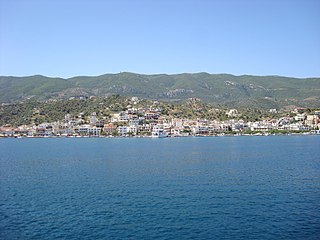
Poros is a small Greek island-pair in the southern part of the Saronic Gulf, about 58 km south of the port of Piraeus and separated from the Peloponnese by a 200 m (656 ft) wide sea channel, with the town of Galatas on the mainland across the strait. Its surface area is about 31 square kilometres (12 sq mi) and it has 3,261 inhabitants (2021). The ancient name of Poros was Pogon. Like other ports in the Saronic, it is a popular weekend destination for Athenian travellers.

<span class="mw-page-title-main">Attica</span> Historical region of Greece, including the city of Athens

Attica, or the Attic Peninsula, is a historical region that encompasses the entire Athens metropolitan area, which consists of the city of Athens, the capital of Greece and the core city of the metropolitan area, as well as its surrounding suburban cities and towns. It is a peninsula projecting into the Aegean Sea, bordering on Boeotia to the north and Megaris to the west. The southern tip of the peninsula, known as Laurion, was an important mining region.

<span class="mw-page-title-main">Kythira</span> Municipality in Greece

Kythira, also transliterated as Cythera, Kythera and Kithira, is an island in Greece lying opposite the south-eastern tip of the Peloponnese peninsula. It is traditionally listed as one of the seven main Ionian Islands, although it is distant from the main group. Administratively, it belongs to the Islands regional unit, which is part of the Attica region, despite its distance from the Saronic Islands, around which the rest of Attica is centered. As a municipality, it includes the island of Antikythera to the south.

Agios Nikolaos is the Greek name of St Nicholas. As a place name, it may refer to:

<span class="mw-page-title-main">Tanagra</span> Municipality in Greece

Tanagra is a town and a municipality north of Athens in Boeotia, Greece. The seat of the municipality is the town Schimatari. It is not far from Thebes, and it was noted in antiquity for the figurines named after it. The Tanagra figurines were a mass-produced, mold-cast and fired type of Greek terracotta figurine produced from the later fourth century BC, primarily in Tanagra.

<span class="mw-page-title-main">Megalochori, Methana</span> Community in Greece

Megalochori is a village and a community in the western part of the volcanic Methana peninsula, Greece. It is located 3 km northwest of Methana town. The community consists of the villages Megalochori, Vathy, Kaimeni Chora and Megalo Potami. The ancient Acropolis of Methana, which was described by Pausanias, is located near Megalochori.

<span class="mw-page-title-main">Troezen</span> Municipal unit in Greece

Troezen is a small town and a former municipality in the northeastern Peloponnese, Greece, on the Argolid Peninsula. Since the 2011 local government reform it is part of the municipality Troizinia-Methana, of which it is a municipal unit. It is part of the Islands regional unit. Population 4,668 (2021).

<span class="mw-page-title-main">Piraeus Prefecture</span> Former prefecture in Attica, Greece

Piraeus Prefecture was one of the prefectures of Greece. Created in 1964 as a separate Prefecture (Νομός) and after the dissolution of the prefecture in 1972 was one of the 4 prefectures (Νομαρχίες) of Attica prefecture, and from 1994, part of the Athens-Piraeus super-prefecture (1994–2011). The capital of the prefecture was Piraeus. As a part of the 2011 Kallikratis government reform, the prefecture was abolished, and its territory was divided into two regional units: Islands and Piraeus.

<span class="mw-page-title-main">Methana Volcano</span>

The Methana volcano peninsula is situated approximately 50 kilometres (31 mi) southwest of Athens in Greece.

<span class="mw-page-title-main">Ano Fanari</span> Community in Greece

Ano Fanari is a mountain village belonging to the Troizinia-Methana municipality in northeastern Peloponnese, Greece. A small acropolis rises above Ano Fanari. It is situated on the old road from Galatas to Agia Eleni and Epidavros.

<span class="mw-page-title-main">Kounoupitsa</span> Community in Greece

Kounoupitsa is a village and a community in the northern end of the Methana peninsula, northeastern Peloponnese, Greece. It is part of the municipality Troizinia-Methana. The community consists of the villages Kounoupitsa, Agios Georgios, Agios Nikolaos, Makrylongos and Palaia Loutra. The population of the community at the 2021 census was 128. Agios Nikolaos is known for its volcanic hot springs.

<span class="mw-page-title-main">Acropolis Palaiokastro</span>

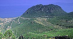
The Acropolis of ancient Methana is located 1 km from the town of Megalochori in the volcanic peninsula of Methana.

The First Peloponnesian War was fought between Sparta as the leaders of the Peloponnesian League and Sparta's other allies, most notably Thebes, and the Delian League led by Athens with support from Argos. This war consisted of a series of conflicts and minor wars, such as the Second Sacred War. There were several causes for the war including the building of the Athenian long walls, Megara's defection and the envy and concern felt by Sparta at the growth of the Athenian Empire.

<span class="mw-page-title-main">Galatas, Troizina</span> Community in Greece

Galatas, is a town located in the eastern part of the Peloponnese peninsula, Greece. It is the seat of the municipality of Troizinia-Methana, which belongs to the Islands regional unit. It is situated on the coast, opposite the island Poros, across a 400 m (1312 ft) wide strait. The community Galatas consists of the main town Galatas and the villages Agia Sotira, Vlachaiika and Saronida.

<span class="mw-page-title-main">Islands (regional unit)</span> Regional unit in Greece

The Islands Regional Unit is one of the regional units of Greece. It is part of the region of Attica. The regional unit covers the Saronic Islands, a small part of the Peloponnese peninsula, and a few islands off the eastern Peloponnese coast.

<span class="mw-page-title-main">Troizinia-Methana</span> Municipality in Greece

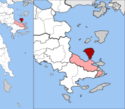
Troizinia-Methana is a municipality in the Islands regional unit, Attica, Greece. The seat of the municipality is the town Galatas.

<span class="mw-page-title-main">Nisaea</span>

Nisaea or Nisaia was the Saronic port town of the ancient polis Megara. In Greek mythology, Nisaea was founded by one of Pandion II's sons, Nisos, who named the region given to him by his father Nisaea, after himself. Control of Nisaea slipped back and forth between Athens and Megara both before and during the Peloponessian War. Athenian allies of the Megarians built long walls which connected Nisaea to Megaris. According to Thucydides, the length of the walls that connected the port to Megara were eight Greek stadia, while Strabo claims the walls to have been 18 stadia in length. A temple of Demeter was located on the road near Nisaea, and a temple of Poseidon located within the port town. Nisaean Megara is thought to have been the birthplace of poet Theognis, but his birthplace is not known for certain The location of the ancient port town remains in debate by historians.

References

  1. "Αποτελέσματα Απογραφής Πληθυσμού - Κατοικιών 2021, Μόνιμος Πληθυσμός κατά οικισμό" [Results of the 2021 Population - Housing Census, Permanent population by settlement] (in Greek). Hellenic Statistical Authority. 29 March 2024.
  2. "ΦΕΚ B 1292/2010, Kallikratis reform municipalities" (in Greek). Government Gazette.
  3. "Population & housing census 2001 (incl. area and average elevation)" (PDF) (in Greek). National Statistical Service of Greece. Archived from the original (PDF) on 2015-09-21.
  4. "List of volcanic eruption sites on Methana". Methana-Promotion.com. Retrieved 11 May 2021.
  5. 1 2 Pausanias (1918). "6.12". Description of Greece. Vol. 3. Translated by W. H. S. Jones; H. A. Ormerod. Cambridge, Massachusetts; London: Harvard University Press; William Heinemann via Perseus Digital Library.
  6. Strabo. Geographica . Vol. viii. p. 374. Page numbers refer to those of Isaac Casaubon 's edition.
  7. Thucydides. History of the Peloponnesian War . Vol. 4.45.
  8. Diodorus Siculus. Bibliotheca historica (Historical Library). Vol. 12.65.
  9. Ptolemy. The Geography . Vol. 3.16.12.
  10. Thucydides , History of the Peloponnesian War   4.45.2
  11. 1 2 "Βυζαντινοί και Μεσαιωνικοί χρόνοι". troizinia-methana.gr. Δήμος Τροιζηνίας-Μεθάνων. Retrieved 2022-01-03.
  12. "Μετά την Ανεξαρτησία". www.troizinia-methana.gr. Δήμος Τροιζηνίας-Μεθάνων. Retrieved 2022-01-03.

PD-icon.svg This article incorporates text from a publication now in the public domain :  Smith, William, ed. (1854–1857). "Methana". Dictionary of Greek and Roman Geography . London: John Murray.