
Satellite temperature measurements are inferences of the temperature of the atmosphere at various altitudes as well as sea and land surface temperatures obtained from radiometric measurements by satellites. These measurements can be used to locate weather fronts, monitor the El Niño-Southern Oscillation, determine the strength of tropical cyclones, study urban heat islands and monitor the global climate. Wildfires, volcanos, and industrial hot spots can also be found via thermal imaging from weather satellites.

A microwave radiometer (MWR) is a radiometer that measures energy emitted at one millimeter-to-metre wavelengths (frequencies of 0.3–300 GHz) known as microwaves. Microwave radiometers are very sensitive receivers designed to measure thermally-emitted electromagnetic radiation. They are usually equipped with multiple receiving channels to derive the characteristic emission spectrum of planetary atmospheres, surfaces or extraterrestrial objects. Microwave radiometers are utilized in a variety of environmental and engineering applications, including remote sensing, weather forecasting, climate monitoring, radio astronomy and radio propagation studies.
The Earth Observing System (EOS) is a program of NASA comprising a series of artificial satellite missions and scientific instruments in Earth orbit designed for long-term global observations of the land surface, biosphere, atmosphere, and oceans. Since the early 1970s, NASA has been developing its Earth Observing System, launching a series of Landsat satellites in the decade. Some of the first included passive microwave imaging in 1972 through the Nimbus 5 satellite. Following the launch of various satellite missions, the conception of the program began in the late 1980s and expanded rapidly through the 1990s. Since the inception of the program, it has continued to develop, including; land, sea, radiation and atmosphere. Collected in a system known as EOSDIS, NASA uses this data in order to study the progression and changes in the biosphere of Earth. The main focus of this data collection surrounds climatic science. The program is the centrepiece of NASA's Earth Science Enterprise.
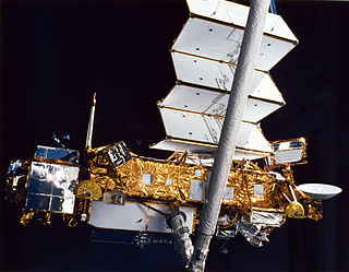
STS-48 was a Space Shuttle mission that launched on September 12, 1991, from Kennedy Space Center, Florida. The orbiter was Space ShuttleDiscovery on her 13th flight. The primary payload was the Upper Atmosphere Research Satellite (UARS). The mission landed on September 18 at 12:38 a.m. EDT at Edwards Air Force Base on runway 22. The mission was completed in 81 revolutions of the Earth and traveled 3,530,369 km (2,193,670 mi). The 5 astronauts carried out a number of experiments and deployed several satellites. The total launch mass was 108,890 kg (240,060 lb) and the landing mass was 87,440 kg (192,770 lb).

The Upper Atmosphere Research Satellite (UARS) was a NASA-operated orbital observatory whose mission was to study the Earth's atmosphere, particularly the protective ozone layer. The 5,900-kilogram (13,000 lb) satellite was deployed from Space Shuttle Discovery during the STS-48 mission on 15 September 1991. It entered Earth orbit at an operational altitude of 600 kilometers (370 mi), with an orbital inclination of 57 degrees.

Aura is a multi-national NASA scientific research satellite in orbit around the Earth, studying the Earth's ozone layer, air quality and climate. It is the third major component of the Earth Observing System (EOS) following on Terra and Aqua. Aura follows on from the Upper Atmosphere Research Satellite (UARS). Aura is a joint mission between NASA, the Netherlands, Finland, and the U.K. The Aura spacecraft is healthy and is expected to operate until at least 2023, likely beyond.

Aqua is a NASA scientific research satellite in orbit around the Earth, studying the precipitation, evaporation, and cycling of water. It is the second major component of the Earth Observing System (EOS) preceded by Terra and followed by Aura.

The advanced microwave sounding unit (AMSU) is a multi-channel microwave radiometer installed on meteorological satellites. The instrument examines several bands of microwave radiation from the atmosphere to perform atmospheric sounding of temperature and moisture levels.

The Tropical Rainfall Measuring Mission (TRMM) was a joint space mission between NASA and JAXA designed to monitor and study tropical rainfall. The term refers to both the mission itself and the satellite that the mission used to collect data. TRMM was part of NASA's Mission to Planet Earth, a long-term, coordinated research effort to study the Earth as a global system. The satellite was launched on 27 November 1997 from the Tanegashima Space Center in Tanegashima, Japan. TRMM operated for 17 years, including several mission extensions, before being decommissioned on 15 April 2015. TRMM re-entered Earth's atmosphere on 16 June 2015.

NOAA-19, known as NOAA-N' before launch, is the last of the American National Oceanic and Atmospheric Administration (NOAA) series of weather satellites. NOAA-19 was launched on 6 February 2009. NOAA-19 is in an afternoon Sun-synchronous orbit and is intended to replace NOAA-18 as the prime afternoon spacecraft.

Over the last two centuries many environmental chemical observations have been made from a variety of ground-based, airborne, and orbital platforms and deposited in databases. Many of these databases are publicly available. All of the instruments mentioned in this article give online public access to their data. These observations are critical in developing our understanding of the Earth's atmosphere and issues such as climate change, ozone depletion and air quality. Some of the external links provide repositories of many of these datasets in one place. For example, the Cambridge Atmospheric Chemical Database, is a large database in a uniform ASCII format. Each observation is augmented with the meteorological conditions such as the temperature, potential temperature, geopotential height, and equivalent PV latitude.
The atmospheric infrared sounder (AIRS) is one of six instruments flying on board NASA's Aqua satellite, launched on May 4, 2002. The instrument is designed to support climate research and improve weather forecasting.

ADEOS I was an Earth observation satellite launched by NASDA in 1996. The mission's Japanese name, Midori means "green". The mission ended in July 1997 after the satellite sustained structural damage to the solar panel. Its successor, ADEOS II, was launched in 2002. Like the first mission, it ended after less than a year, also following solar panel malfunctions.

The Joint Polar Satellite System (JPSS) is the latest generation of U.S. polar-orbiting, non-geosynchronous, environmental satellites. JPSS will provide the global environmental data used in numerical weather prediction models for forecasts, and scientific data used for climate monitoring. JPSS will aid in fulfilling the mission of the U.S. National Oceanic and Atmospheric Administration (NOAA), an agency of the Department of Commerce. Data and imagery obtained from the JPSS will increase timeliness and accuracy of public warnings and forecasts of climate and weather events, thus reducing the potential loss of human life and property and advancing the national economy. The JPSS is developed by the National Aeronautics and Space Administration (NASA) for the National Oceanic and Atmospheric Administration (NOAA), who is responsible for operation of JPSS. Three to five satellites are planned for the JPSS constellation of satellites. JPSS satellites will be flown, and the scientific data from JPSS will be processed, by the JPSS – Common Ground System (JPSS-CGS).
GEOMS – Generic Earth Observation Metadata Standard is a metadata standard used for archiving data from groundbased networks, like the Network for the Detection of Atmospheric Composition Change (NDACC), and for using this kind of data for the validation of NASA and ESA satellite data.

The Suomi National Polar-orbiting Partnership, previously known as the National Polar-orbiting Operational Environmental Satellite System Preparatory Project (NPP) and NPP-Bridge, is a weather satellite operated by the United States National Oceanic and Atmospheric Administration (NOAA). It was launched in 2011 and is currently in operation.

NOAA-21, designated JPSS-2 prior to launch, is the second satellite in National Oceanic and Atmospheric Administration (NOAA)'s latest series of U.S. polar-orbiting, non-geosynchronous, environmental satellites, known as the Joint Polar Satellite System (JPSS). Launched on November 10, 2022, along with LOFTID, NOAA-21 now operates in the same orbit as NOAA-20 and Suomi NPP. It travels in a polar orbit, crossing the equator approximately 14 times a daily, and provides complete global coverage twice a day.
NOAA-20, designated JPSS-1 prior to launch, is the first of the United States National Oceanic and Atmospheric Administration's latest generation of U.S. polar-orbiting, non-geosynchronous, environmental satellites called the Joint Polar Satellite System. NOAA-20 was launched on 18 November 2017 and joined the Suomi National Polar-orbiting Partnership satellite in the same orbit. NOAA-20 operates about 50 minutes behind Suomi NPP, allowing important overlap in observational coverage. Circling the Earth from pole-to-pole, it crosses the equator about 14 times daily, providing full global coverage twice a day. This gives meteorologists information on "atmospheric temperature and moisture, clouds, sea-surface temperature, ocean color, sea ice cover, volcanic ash, and fire detection" so as to enhance weather forecasting including hurricane tracking, post-hurricane recovery by detailing storm damage and mapping of power outages.
Moustafa T. Chahine was an atmospheric scientist and an international leader in atmospheric remote sensing using satellite observations. He was the Science Team Leader for the Atmospheric Infrared Sounder on NASA's Earth Observing System Aqua satellite, and the Chairman of the Global Energy and Water Exchanges (GEWEX) Science Steering Group of the World Climate Research Program (WCRP).
Anne Ritger Douglass is atmospheric physicist known for her research on chlorinated compounds and the ozone layer.