
The Shenandoah River is the principal tributary of the Potomac River, 55.6 miles (89.5 km) long with two forks approximately 100 miles (160 km) long each, in the U.S. states of Virginia and West Virginia. The river and its tributaries drain the central and lower Shenandoah Valley and the Page Valley in the Appalachians on the west side of the Blue Ridge Mountains, in northwestern Virginia and the Eastern Panhandle of West Virginia. There is a hydroelectric plant along the Shenandoah river constructed in 2014 by Dominion.

The Holston River is a 136-mile (219 km) river that flows from Kingsport, Tennessee, to Knoxville, Tennessee. Along with its three major forks, it comprises a major river system that drains much of northeastern Tennessee, southwestern Virginia, and northwestern North Carolina. The Holston's confluence with the French Broad River at Knoxville marks the beginning of the Tennessee River.

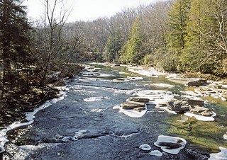
The Dry Fork is a 39.1-mile-long (62.9 km) tributary of the Black Fork of the Cheat River in the Allegheny Mountains of eastern West Virginia, USA. Via the Black Fork, the Cheat, and the Monongahela and Ohio rivers, it is part of the watershed of the Mississippi River. The Dry Fork flows for much of its length in the Monongahela National Forest and drains mostly rural and forested areas. It was traditionally considered one of the five Forks of Cheat.

The Williams River is a tributary of the Gauley River, 33 miles (53 km) long, in east-central West Virginia, USA. Via the Gauley, Kanawha and Ohio Rivers, it is part of the watershed of the Mississippi River, draining an area of 132 square miles (342 km²) in a sparsely populated region of the southern Allegheny Mountains and the unglaciated portion of the Allegheny Plateau.
Sleepy Creek is a 44.0-mile-long (70.8 km) tributary of the Potomac River in the United States, belonging to the Chesapeake Bay's watershed. The stream rises in Frederick County, Virginia, and flows through Morgan County, West Virginia before joining the Potomac near the community of Sleepy Creek.

Audra State Park is a West Virginia state park located on 355 acres (1.44 km2) in southwestern Barbour County. It was established around the remnants of an early 19th-century gristmill and the tiny community of Audra. A gristmill spillway is still visible in the river.

Glady Fork is a 31.9-mile-long (51.3 km) river in the Allegheny Mountains of eastern West Virginia, USA. It is considered one of the five principal headwaters tributaries of the Cheat River — known as the Forks of Cheat.

Laurel Fork is a 37.8-mile-long (60.8 km) river in eastern West Virginia, USA. It is a tributary of the Dry Fork; via the Dry Fork, the Black Fork, and the Cheat, Monongahela and Ohio rivers, it is part of the watershed of the Mississippi River, draining an area of 60 square miles (160 km2) in the Allegheny Mountains. With the Dry Fork, the Glady Fork, the Shavers Fork and the Blackwater River, it is considered to be one of the five principal headwaters tributaries of the Cheat River.
The Middle Fork River is a 35.4-mile-long (57.0 km) tributary of the Tygart Valley River in north-central West Virginia, USA. Via the Tygart Valley, Monongahela and Ohio rivers, it is part of the watershed of the Mississippi River, draining an area of 152 square miles (390 km2) on the easternmost part of the unglaciated portion of the Allegheny Plateau. According to the Geographic Names Information System, the Middle Fork River has also been known simply as "Middle Fork" and as "Middlefork."

Wheeling Creek is a tributary of the Ohio River, 25 miles (40 km) long, in the Northern Panhandle of West Virginia in the United States, with a watershed extending into southwestern Pennsylvania. Via the Ohio River, it is part of the watershed of the Mississippi River, draining an area of approximately 300 square miles (780 km2) on the unglaciated portion of the Allegheny Plateau. It flows into the Ohio River in downtown Wheeling, just downstream of Ohio's Wheeling Creek on the opposite bank. A variant name is Big Wheeling Creek.

Laurel Fork South Wilderness is a U.S. Wilderness Area located in the Greenbrier Ranger District of Monongahela National Forest in West Virginia. The Wilderness protects high-elevation lands along Laurel Fork and is bordered by Middle Mountain to the west. It is a companion to Laurel Fork North Wilderness, the two being split by Randolph County Route 40. Laurel Fork South contains 9 miles (14 km) of hiking trails.

Laurel Fork North Wilderness is a U.S. Wilderness Area located in the Greenbrier Ranger District of Monongahela National Forest in West Virginia. The Wilderness protects high-elevation lands along Laurel Fork and is bordered by Middle Mountain to the west. It is a companion to Laurel Fork South Wilderness, the two being split by Randolph County Route 40. Laurel Fork North contains 9.5 miles (15.3 km) of hiking trails.
Cassity is an unincorporated community in Randolph County, West Virginia, United States. Cassity is located at the confluence of the Cassity Fork and the Middle Fork River along County Route 35, 8.7 miles (14.0 km) west of Beverly.

Shively is an unincorporated community located on the Smokehouse Fork of Big Harts Creek in Logan County, West Virginia, United States. Shively is accessed by County Route 3. It is situated 7.2 miles from Harts and 9.3 miles from Chapmanville.
Halcyon is an unincorporated community located on the West Fork of Big Harts Creek in Logan and Lincoln counties, West Virginia, United States.

The Laurel Fork is a 15.7-mile-long (25.3 km) stream in Virginia and West Virginia, United States. The stream flows north from Highland County, Virginia, where its source and the majority of its length is located, to its mouth in Pendleton County, West Virginia. Laurel Fork is a tributary to the North Fork South Branch Potomac River, making it a part of the Potomac River watershed. The area surrounding Laurel Fork is home to several plant and animal species found nowhere else in Virginia, and is a prime example of a northern boreal forest in the state.
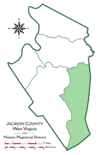
Washington District, formerly Washington Magisterial District, is one of five historic magisterial districts in Jackson County, West Virginia, United States. The district was originally established as one of five civil townships in Jackson County after West Virginia became a state in 1863; in 1872, all of West Virginia's townships were converted into magisterial districts. When Jackson County was redistricted in the 1990s, Washington District was combined with the eastern portion of Ripley District, including the city of Ripley, to form the new Eastern Magisterial District. However, the county's historic magisterial districts continue to exist in the form of tax districts, serving all of their former administrative functions except for the election of county officials.

The Eastern Magisterial District is one of three magisterial districts in Jackson County, West Virginia, United States. It was established during a process of redistricting undertaken in the 1990s. In 2010, 9,882 people lived in the district.


