
Milstar is a constellation of military communications satellites in geosynchronous orbit, which are operated by the United States Space Force, and provide secure and jam-resistant worldwide communications to meet the requirements of the Armed Forces of the United States. Six spacecraft were launched between 1994 and 2003, of which only five were operational after launch; the third launch failed, both damaging the satellite and leaving it in an unusable orbit.
Spacecraft design is a process where systems engineering principles are systemically applied in order to construct complex vehicles for missions involving travel, operation or exploration in outer space. This design process produces the detailed design specifications, schematics, and plans for the spacecraft system, including comprehensive documentation outlining the spacecraft's architecture, subsystems, components, interfaces, and operational requirements, and potentially some prototype models or simulations, all of which taken together serve as the blueprint for manufacturing, assembly, integration, and testing of the spacecraft to ensure that it meets mission objectives and performance criteria.

TacSat-2 is the first in a series of U.S. military experimental technology and communication satellites.TacSat-2 (also known as JWS-D1 was an experimental satellite built by the USAF's Air Force Research Laboratory with an operational life expected to be not more than one year as part of the "Advanced Concept Technology Demonstration" program.
The STAR-2 Bus is a fully redundant, flight-proven, spacecraft bus designed for geosynchronous missions.
ITUpSAT1, short for Istanbul Technical University picoSatellite-1, is a single CubeSat built by the Faculty of Aeronautics and Astronautics at the Istanbul Technical University. It was launched on 23 September 2009 atop a PSLV-C14 satellite launch vehicle from Satish Dhawan Space Centre, Sriharikota, Andhra Pradesh in India, and became the first Turkish university satellite to orbit the Earth. It was expected to have a minimum of six-month life term, but it is still functioning for over two years. It is a picosatellite with side lengths of 10 centimetres (3.9 in) and a mass of 0.990 kilograms (2.18 lb).
SSETI Express was the first spacecraft to be designed and built by European students and was launched by the European Space Agency. SSETI Express is a small spacecraft, similar in size and shape to a washing machine. On board the student-built spacecraft were three CubeSat picosatellites, extremely small satellites weighing around one kg each. These were deployed one hour and forty minutes after launch. Twenty-one university groups, working from locations spread across Europe and with very different cultural backgrounds, worked together via the internet to jointly create the satellite. The expected lifetime of the mission was planned to be 2 months. SSETI Express encountered an unusually fast mission development: less than 18 months from kick-off in January 2004 to flight-readiness.
Space Technology 6 (ST-6) is part of the NASA New Millennium Program. ST-6 is a subsystem technology demonstration that consisted of 2 separate projects, the Autonomous Sciencecraft Experiment on board the Earth Observing 1 satellite and the Inertial Stellar Compass (ISC) experiment aboard TacSat-2.
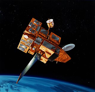
ADEOS II was an Earth observation satellite (EOS) launched by NASDA, with contributions from NASA and CNES, in December 2002. and it was the successor to the 1996 mission ADEOS I. The mission ended in October 2003 after the satellite's solar panels failed.

RAX-2 is a CubeSat satellite built as a collaboration between SRI International and students at the University of Michigan College of Engineering. It is the second spacecraft in the RAX mission. The RAX-1 mission ended after approximately two months of operation due to a gradual degradation of the solar panels that ultimately resulted in a loss of power. RAX team members applied the lessons learned from RAX-1 to the design of a second flight unit, RAX-2, which performs the same mission concept of RAX-1 with improved bus performance and additional operational modes. Science measurements are enhanced through interactive experiments with high power ionospheric heaters where FAI will be generated on demand.

The Suomi National Polar-orbiting Partnership, previously known as the National Polar-orbiting Operational Environmental Satellite System Preparatory Project (NPP) and NPP-Bridge, is a weather satellite operated by the United States National Oceanic and Atmospheric Administration (NOAA). It was launched in 2011 and is currently in operation.

DubaiSat-2 is an electro-optical Earth observation satellite built by the Mohammed bin Rashid Space Centre (MBRSC) under an agreement with Satrec Initiative, a satellite manufacturing company in South Korea. MBRSC's objective with DubaiSat-2 is to provide electro-optical images, that can be commercialized, for users within the United Arab Emirates and beyond and to develop and implement new technologies not used in DubaiSat-1. MBRSC also intends to continue manpower training for the UAE's space program. 16 UAE engineers have been working on the design, development, testing and manufacturing of the satellite. The participation of the UAE engineers, who are currently working in South Korea, has increased by 100 percent from the DubaiSat-1 project.
Space Tethered Autonomous Robotic Satellite II or STARS-II, was a nanosatellite built by Japan's Kagawa University to test an electrodynamic tether in low Earth orbit, a follow-on to the STARS mission.
SOCRATES or Space Optical Communications Research Advanced Technology Satellite is a Japanese small satellite launched in 2014. The satellite is purely a technology demonstrator designed by NICT intended to help AES company to gain experience in basic mission control, attitude control and spacecraft communications. Its main experiment is SOTA, an optical small satellite communications demonstrator. All subsystems of spacecraft are powered by solar cells mounted on spacecraft body and stub wings, with estimated electrical power of 120W BOL degrading to 100W EOL.
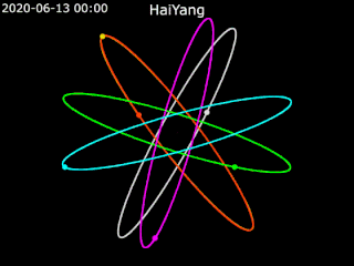
Haiyang is a series of marine remote sensing satellites developed and operated by the People's Republic of China since 2002. The name "Haiyang" translates to "ocean" in English. As of October 2022, eight satellites have been launched with ten more planned. Built by the state-owned aerospace contractor China Academy of Space Technology (CAST), Haiyang satellites carry a variety of ocean-imaging sensor payloads and are operated by the National Satellite Ocean Application Service (NSOAS), a subordinate agency of the State Oceanic Administration (SOA). Haiyang satellites are launched from Taiyuan Satellite Launch Center (TSLC) into Sun-synchronous orbit (SSO) aboard Long March-series rockets.

The spacecraft bus is a carbon fibre box that houses systems of the telescope and so is the primary support element of the James Webb Space Telescope, launched on 25 December 2021. It hosts a multitude of computing, communication, propulsion, and structural components. The other three elements of the JWST are the Optical Telescope Element (OTE), the Integrated Science Instrument Module (ISIM), and the sunshield. Region 3 of ISIM is also inside the spacecraft bus. Region 3 includes the ISIM Command and Data Handling subsystem and the Mid-Infrared Instrument (MIRI) cryocooler.

Earth Escape Explorer (CU-E3) is a nanosatellite of the 6U CubeSat format that will demonstrate long-distance communications while in heliocentric orbit.

Deep Space Optical Communications (DSOC) is a laser space communication system in operation that improved communications performance 10 to 100 times over radio frequency technology without incurring increases in mass, volume or power. DSOC is capable of providing high bandwidth downlinks from beyond cislunar space.
NASA's Pathfinder Technology Demonstrator (PTD) Project is a series of tech demonstrations of technologies aboard a series of nanosatellites known as CubeSats, providing significant enhancements to the performance of these versatile spacecraft. Each of the five planned PTD missions consist of a 6-unit (6U) CubeSat with expandable solar arrays.

The Nanosat 01, sometimes written as NanoSat-1 or NanoSat 01, was an artificial satellite developed by the Spanish Instituto Nacional de Técnica Aeroespacial (INTA) and launched 18 December 2004. Considered a nano satellite for its weight of less than 20 kg, its main mission was forwarding communications between far reaching points of the Earth such as Juan Carlos I Antarctic Base from mainland Spain. This was possible due to its polar orbit and altitude of 650 km above sea level. During an operational run the data obtained in the Antarctic would be uploaded to the satellite during its fly by and then, downloaded in Spain when satellite reached the Iberian Peninsula.

OPTOS was a Spanish nanosatellite designed and developed by INTA with support from the European Cooperation for Space Standardization (ECSS) as a low-cost technology demonstrator. It was launched in 2013 and had a service life of three years.
