
The European Space Operations Centre (ESOC) serves as the main mission control centre for the European Space Agency (ESA) and is located in Darmstadt, Germany. ESOC's primary function is the operation of unmanned spacecraft on behalf of ESA and the launch and early orbit phases (LEOP) of ESA and third-party missions. The Centre is also responsible for a range of operations-related activities within ESA and in cooperation with ESA's industry and international partners, including ground systems engineering, software development, flight dynamics and navigation, development of mission control tools and techniques and space debris studies.
A spacecraft is a vehicle or machine designed to fly in outer space. A type of artificial satellite, spacecraft are used for a variety of purposes, including communications, Earth observation, meteorology, navigation, space colonization, planetary exploration, and transportation of humans and cargo. All spacecraft except single-stage-to-orbit vehicles cannot get into space on their own, and require a launch vehicle.

A robotic spacecraft is an uncrewed spacecraft, usually under telerobotic control. A robotic spacecraft designed to make scientific research measurements is often called a space probe. Many space missions are more suited to telerobotic rather than crewed operation, due to lower cost and lower risk factors. In addition, some planetary destinations such as Venus or the vicinity of Jupiter are too hostile for human survival, given current technology. Outer planets such as Saturn, Uranus, and Neptune are too distant to reach with current crewed spacecraft technology, so telerobotic probes are the only way to explore them.

SMART-1 was a Swedish-designed European Space Agency satellite that orbited around the Moon. It was launched on 27 September 2003 at 23:14 UTC from the Guiana Space Centre in Kourou, French Guiana. "SMART-1" stands for Small Missions for Advanced Research in Technology-1. On 3 September 2006, SMART-1 was deliberately crashed into the Moon's surface, ending its mission.

DART, or Demonstration for Autonomous Rendezvous Technology, was a NASA spacecraft with the goal to develop and demonstrate an automated navigation and rendezvous capability. At the time of the DART mission, only the Roscosmos and JAXA had autonomous spacecraft navigation. Orbital Sciences Corporation (OSC) was the prime contractor for construction, launch and operation of the DART spacecraft with a project cost of US$110 million (2005). The contract was awarded in June 2001 and the spacecraft was launched on 15 April 2005. The mission ended prematurely, very shortly after an anomalous slow-velocity collision with its target spacecraft, having completed less than half of the original mission autonomous rendezvous objectives.
The design of spacecraft covers a broad area, including the design of both robotic spacecraft, and spacecraft for human spaceflight.

FalconSAT is the United States Air Force Academy's (USAFA) small satellite engineering program. Satellites are designed, built, tested, and operated by Academy cadets. The project is administered by the USAFA Space Systems Research Center under the direction of the Department of Astronautics. Most of the cadets who work on the project are pursuing a bachelor of science degree in astronautical engineering, although students from other disciplines join the project.
GIOVE, or Galileo In-Orbit Validation Element, is the name for two satellites built for the European Space Agency (ESA) to test technology in orbit for the Galileo positioning system.
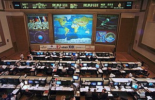
Flight controllers are personnel who aid space flight by working in such Mission Control Centers as NASA's Mission Control Center or ESA's European Space Operations Centre. Flight controllers work at computer consoles and use telemetry to monitor various technical aspects of a space mission in real time. Each controller is an expert in a specific area and constantly communicates with additional experts in the "back room". The flight director, who leads the flight controllers, monitors the activities of a team of flight controllers, and has overall responsibility for success and safety.
The on-board data handling (OBDH) subsystem of a spacecraft is the subsystem which carries and stores data between the various electronics units and the ground segment, via the telemetry, tracking and command (TT&C) subsystem.
STARMAD deals with the latest trend in the space industry is towards space missions, spacecraft, systems and products, which require quick solutions for system design and software development.
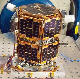
Formation Autonomy Spacecraft with Thrust, Relnav, Attitude and Crosslink is a pair of nanosatellites developed and built by students at The University of Texas at Austin. The project is part of a program sponsored by the Air Force Research Laboratory (AFRL), whose goal is to lead the development of affordable space technology. The FASTRAC mission will specifically investigate technologies that facilitate the operation of multiple satellites in formation. These enabling technologies include relative navigation, cross-link communications, attitude determination, and thrust. Due to the high cost of lifting mass into orbit, there is a strong initiative to miniaturize the overall weight of spacecraft. The utilization of formations of satellites, in place of large single satellites, reduces the risk of single point failure and allows for the use of low-cost hardware.

DRAGONSat is a pair of nanosatellites that will be demonstrating autonomous rendezvous and docking (ARD) in low Earth orbit (LEO) for NASA. It will be gathering flight data with a global positioning system (GPS) receiver strictly designed for space applications to gather flight data in the space environment. ARD is the capability of two independent spacecraft to rendezvous in orbit and dock without crew intervention. One DRAGONSat was built by the University of Texas and the other one was built by Texas A and M University, the Space Shuttle Payload Launcher (SSPL), These satellite projects will rendezvous and dock with each other in space without the benefit of human intervention.
SSETI Express was the first spacecraft to be designed and built by European students and was launched by the European Space Agency. SSETI Express is a small spacecraft, similar in size and shape to a washing machine. On board the student-built spacecraft were three CubeSat pico-satellites, extremely small satellites weighing around one kg each. These were deployed one hour and forty minutes after launch. 23 university groups, working from locations spread across Europe and with very different cultural backgrounds, worked together via the internet to jointly create the satellite. The expected lifetime of the mission was planned to be 2 months. Express is the fastest developed micro-satellite in history.
Chasqui I is a one-kilogram nanosatellite project that was launched by hand from the International Space Station during a spacewalk on August 18, 2014. The concept satellite was equipped with two cameras, a visible and an infrared, which could take photos of the Earth.

Radio Aurora Explorer (RAX) is the first National Science Foundation sponsored CubeSat mission. The RAX mission is a joint effort between SRI International in Menlo Park, California and the University of Michigan in Ann Arbor, Michigan. The chief scientist at SRI International, Dr. Hasan Bahcivan, led his team at SRI to develop the payload while the chief engineer, Dr. James Cutler, led a team of students to develop the satellite bus in the Michigan Exploration Laboratory. There are currently two satellites in the RAX mission.
Attitude control is the process of controlling the orientation of an aerospace vehicle with respect to an inertial frame of reference or another entity such as the celestial sphere, certain fields, and nearby objects, etc.

Swayam is a 1-U picosatellite (CubeSat) developed by the undergraduate students of College of Engineering, Pune. They have successfully completed assembly of the flight model having a size of 1-U and weight of 990 grams under the guidance of Indian Space Research Organisation (ISRO) in January 2015. The structural design of the satellite, design of its electronic and control systems as well as the manufacturing of the satellite was carried out by the students. The project was completed over a span of 8 years and more than 200 students worked on it. The Satellite was launched by ISRO on June 22, 2016 along with Cartosat-2C by Polar Satellite Launch Vehicle C-34 from the second launch pad at Satish Dhawan Space Center, Sriharikota, India. The satellite is to be placed in low earth orbit (LEO) around the Earth at a height of 515 km.

A ground segment consists of all the ground-based elements of a spacecraft system used by operators and support personnel, as opposed to the space segment and user segment. The ground segment enables management of a spacecraft, and distribution of payload data and telemetry among interested parties on the ground. The primary elements of a ground segment are:
ArgoMoon is a nanosatellite that will fly on NASA's Artemis 1 mission into a heliocentric orbit in cislunar space on the maiden flight of the Space Launch System (SLS) and the Orion spacecraft, in 2021. The satellite has the dimensions of a shoe box in CubeSat terms, it is a 6U.