SARAL

Last updated • 4 min readFrom Wikipedia, The Free Encyclopedia

SARAL
SARAL.jpg
An artist's rendering of SARAL satellite
NamesSatellite with Argos and ALtiKa
Mission type Earth observation
Operator ISRO
COSPAR ID 2013-009A OOjs UI icon edit-ltr-progressive.svg
SATCAT no. 39086
Website https://isro.gov.in/
Mission duration5 years (planned)
11 years, 8 months and 11 days (in progress)
Spacecraft properties
SpacecraftSARAL
Bus IMS-2
Manufacturer Indian Space Research Organisation / CNES
Launch mass407 kg (897 lb) [1] [2]
Dimensions1 m x 1 m x 0.6 m
Power850 watts
Start of mission
Launch date25 February 2013, 12:31 UTC [3]
Rocket Polar Satellite Launch Vehicle-CA, PSLV-C20
Launch site Satish Dhawan Space Centre, First Launch Pad (FLP)
Contractor Indian Space Research Organisation
Entered service25 June 2013
Orbital parameters
Reference system Geocentric orbit
Regime Sun-synchronous orbit
Perigee altitude 790 km (490 mi)
Apogee altitude 791 km (492 mi)
Inclination 98.54°
Period 100.54 minutes
Instruments
Advanced Data Collection System ("Argos-3") (A-DCS)
Ka-band Altimeter (ALtiKa)
Doppler Orbitography and Radiopositioning Integrated by Satellite (DORIS)
Laser Retroreflector Array (LRA)
  RISAT-1

SARAL (Satellite with ARgos and ALtiKa) is a cooperative altimetry technology mission of Indian Space Research Organisation (ISRO) and Centre National d'Études Spatiales (CNES). SARAL performs altimetric measurements designed to study ocean circulation and sea surface elevation. [2] [4]

Contents

Mission

A CNES / ISRO MOU (Memorandum of Understanding) on the SARAL mission was signed on 23 February 2007. [5] The SARAL mission is complementary to the Jason-2 mission of NASA / NOAA and CNES / EUMETSAT. It will fill the gap between Envisat and the Sentinel-3 mission of the European Copernicus Programme (Global Monitoring for Environment and Security - GMES programme). The combination of two altimetry missions in orbit has a considerable impact on the reconstruction of sea surface height (SSH), reducing the mean mapping error by a factor of 4. [5]

Instruments

The SARAL payload module was provided by CNES: ALtiKa (Ka-band altimeter), Doppler Orbitography and Radiopositioning Integrated by Satellite (DORIS), Laser Retroreflector Array (LRA), and ARGOS data collection system. ISRO is responsible for the satellite bus (Indian Mini Satellite-2), launch (Polar Satellite Launch Vehicle), and operations of the satellite.

ARGOS Advanced-Data Collection System (A-DCS)

Argos-3 of French National Space Agency (CNES), manufactured by Thales Alenia Space (TAS). ARGOS contributes to the development and operational implementation of the global ARGOS Advanced-Data Collection System. It will collect a variety of data from ocean buoys to transmit the same to the ARGOS ground segment for subsequent processing and distribution. [5]

Ka-band altimeter (ALtiKa)

ALtiKa, the altimeter and prime payload of the SARAL mission, is the first spaceborne altimeter to operate at Ka-band. [6] It was built by the French National Space Agency, CNES. The payload is intended for oceanographic applications, operates at 35.75 GHz. [1] ALTIKA is set to take over ocean-monitoring from Envisat. It is the first to operate at such a high frequency, making it more compact and delivering better performance than the previous generation. [7]

While existing satellite-borne altimeters determine sea level by bouncing a radar signal off the surface and measuring the return-trip time, ALtiKa operates at a high frequency in Ka-band. The advantage of this is twofold. One, the atmosphere of Earth slows down the radar signal, so altimetry measurements are skewed and have to carry additional equipment to correct for this error. Since ALTIKA uses a different system, it does not have to carry an instrument to correct for atmospheric effects as current-generation altimeters do. ALtiKa gets around this problem by operating at a high frequency in Ka-band. Another advantage of operating at higher frequencies is greater accuracy. ALtiKa will measure ocean surface topography with an accuracy of 8 mm, against 2.5 cm on average using current-generation altimeters, and with a spatial resolution of 2 km. The disadvantage, however, is that high-frequency waves are extremely sensitive to rain, even drizzle. 10% of the data is expected to be lost. (Although this could be exploited to perform crude measurements of precipitation). [7]

DORIS

DORIS (Doppler Orbitography and Radiopositioning Integrated by Satellite): DORIS is a dual-frequency tracking system (400 MHz and 2 GHz) based on network of emitting ground beacons spread all over the world. [5]

Laser Retroreflector Array (LRA)

LRA is provided by CNES. The objective of LRA is to calibrate the precise orbit determination system and the altimeter system several times throughout the mission. The LRA is a passive system used to locate the satellite with laser shots from ground stations with an accuracy of a few millimeters. The reflective function is done by a set of 9 corner cube reflectors, with a conical arrangement providing a 150º wide field of view over the full 360° azimuth angle. [5]

Applications

SARAL data products is useful for operational as well as research user communities in many fields like: [1]

Secondary payloads

The six secondary payloads manifested on this flight were: [5]

BRITE-Austria (CanX-3b) and UniBRITE (CanX-3a), both of Austria. UniBRITE and BRITE-Austria are part of the BRITE Constellation, short for "BRIght-star Target Explorer Constellation", a group of 6.5 kg, 20 cm x 20 cm x 20 cm nanosatellites who purpose is to photometrically measure low-level oscillations and temperature variations in the sky's 286 stars brighter than visual magnitude 3.5.

Sapphire (Space Surveillance Mission of Canada), a minisatellite with a mass of 148 kg.

NEOSSat (Near Earth Object Surveillance Satellite), a microsatellite of Canada with a mass of ~74 kg.

AAUSAT3 (Aalborg University CubeSat-3), a student-developed nanosatellite (1U CubeSat) of AAU, Aalborg, Denmark. The project is sponsored by DaMSA (Danish Maritime Safety Organization).

STRaND-1 (Surrey Training, Research and Nanosatellite Demonstrator), a 3U CubeSat (nanosatellite) of SSTL (Surrey Satellite Technology Limited) and the USSC (University of Surrey Space Centre), Guildford, United Kingdom. STRaND-1 has a mass of ~4.3 kg.

The University of Toronto arranged for the launch to carry three small satellites for universities as part of its Nanosatellite Launch Services program, designated NLS-8: BRITE-Austria, UniBRITE and AAUSat3. The three NLS satellites used the XPOD (Experimental Push Out Deployer) separation mechanism of UTIAS/SFL for deployment. The STRaND-1 nanosatellite was deployed with the ISIPOD CubeSat dispenser of ISIS (Innovative Solutions In Space).

Launch

SARAL was successfully launched into a Sun-synchronous orbit (SSO) on 25 February 2013, at 12:31 UTC. [8] [3]

Related Research Articles

<span class="mw-page-title-main">Envisat</span> ESA Earth observation satellite (2002–2012)

Envisat is a large Earth-observing satellite which has been inactive since 2012. It is still in orbit and considered space debris. Operated by the European Space Agency (ESA), it was the world's largest civilian Earth observation satellite.

<span class="mw-page-title-main">Jason-1</span> Satellite oceanography mission

Jason-1 was a satellite altimeter oceanography mission. It sought to monitor global ocean circulation, study the ties between the ocean and the atmosphere, improve global climate forecasts and predictions, and monitor events such as El Niño and ocean eddies. Jason-1 was launched in 2001 and it was followed by OSTM/Jason-2 in 2008, and Jason-3 in 2016 – the Jason satellite series. Jason-1 was launched alongside the TIMED spacecraft.

<span class="mw-page-title-main">Space-based radar</span> Use of radar systems mounted on satellites

Space-based radar or spaceborne radar is a radar operating in outer space; orbiting radar is a radar in orbit and Earth orbiting radar is a radar in geocentric orbit. A number of Earth-observing satellites, such as RADARSAT, have employed synthetic aperture radar (SAR) to obtain terrain and land-cover information about the Earth.

<span class="mw-page-title-main">TOPEX/Poseidon</span> Satellite mission to map ocean surface topography

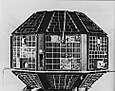
TOPEX/Poseidon was a joint satellite altimeter mission between NASA, the U.S. space agency; and CNES, the French space agency, to map ocean surface topography. Launched on August 10, 1992, it was the first major oceanographic research satellite. TOPEX/Poseidon helped revolutionize oceanography by providing data previously impossible to obtain. Oceanographer Walter Munk described TOPEX/Poseidon as "the most successful ocean experiment of all time." A malfunction ended normal satellite operations in January 2006.

The Canadian Advanced Nanospace eXperiment (CanX) program is a Canadian CubeSat nanosatellite program operated by the University of Toronto Institute for Aerospace Studies, Space Flight Laboratory (UTIAS/SFL). The program's objectives are to involve graduate students in the process of spaceflight development, and to provide low-cost access to space for scientific research and the testing of nanoscale devices. The CanX projects include CanX-1, CanX-2, the BRIght Target Explorer (BRITE), and CanX-4&5.

<span class="mw-page-title-main">OSTM/Jason-2</span> International Earth observation satellite mission

OSTM/Jason-2, or Ocean Surface Topography Mission/Jason-2 satellite, was an international Earth observation satellite altimeter joint mission for sea surface height measurements between NASA and CNES. It was the third satellite in a series started in 1992 by the NASA/CNES TOPEX/Poseidon mission and continued by the NASA/CNES Jason-1 mission launched in 2001.

<span class="mw-page-title-main">DORIS (satellite system)</span> Doppler-radio-based system for determination of satellite orbits and ground station locations

DORIS is a French satellite system used for the determination of satellite orbits and for positioning. The name is an acronym of "Doppler Orbitography and Radiopositioning Integrated by Satellite" or, in French, Détermination d'Orbite et Radiopositionnement Intégré par Satellite.

<span class="mw-page-title-main">Sentinel-3</span> Earth observation satellite series

Sentinel-3 is an Earth observation heavy satellite series developed by the European Space Agency as part of the Copernicus Programme. As of 2024, it consists of 2 satellites: Sentinel-3A and Sentinel-3B. After initial commissioning, each satellite was handed over to EUMETSAT for the routine operations phase of the mission. Two recurrent satellites, Sentinel-3C and Sentinel-3D, will follow in approximately 2025 and 2028 respectively to ensure continuity of the Sentinel-3 mission.

<span class="mw-page-title-main">Surface Water and Ocean Topography</span> NASA/CNES oceanography mission (2022–Present)

The Surface Water and Ocean Topography (SWOT) mission is a satellite altimeter jointly developed and operated by NASA and CNES, the French space agency, in partnership with the Canadian Space Agency (CSA) and UK Space Agency (UKSA). The objectives of the mission are to make the first global survey of the Earth's surface water, to observe the fine details of the ocean surface topography, and to measure how terrestrial surface water bodies change over time.

<span class="mw-page-title-main">Ocean surface topography</span> Shape of the ocean surface relative to the geoid

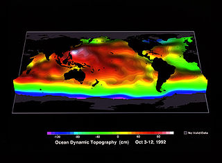
Ocean surface topography or sea surface topography, also called ocean dynamic topography, are highs and lows on the ocean surface, similar to the hills and valleys of Earth's land surface depicted on a topographic map. These variations are expressed in terms of average sea surface height (SSH) relative to Earth's geoid. The main purpose of measuring ocean surface topography is to understand the large-scale ocean circulation.

ITUpSAT1, short for Istanbul Technical University picoSatellite-1, is a single CubeSat built by the Faculty of Aeronautics and Astronautics at the Istanbul Technical University. It was launched on 23 September 2009 atop a PSLV-C14 satellite launch vehicle from Satish Dhawan Space Centre, Sriharikota, Andhra Pradesh in India, and became the first Turkish university satellite to orbit the Earth. It was expected to have a minimum of six-month life term, but it is still functioning for over two years. It is a picosatellite with side lengths of 10 centimetres (3.9 in) and a mass of 0.990 kilograms (2.18 lb).

<span class="mw-page-title-main">Jason-3</span> International Earth observation satellite mission

Jason-3 is a satellite altimeter created by a partnership of the European Organisation for the Exploitation of Meteorological Satellites (EUMETSAT) and National Aeronautic and Space Administration (NASA), and is an international cooperative mission in which National Oceanic and Atmospheric Administration (NOAA) is partnering with the Centre National d'Études Spatiales. The satellite's mission is to supply data for scientific, commercial, and practical applications to sea level rise, sea surface temperature, ocean temperature circulation, and climate change.

TUGSAT-1, also known as BRITE-Austria and CanX-3B, is the first Austrian satellite. It is an optical astronomy spacecraft operated by the Graz University of Technology as part of the international BRIght-star Target Explorer programme.

UniBRITE-1 is, along with TUGSAT-1, one of the first two Austrian satellites to be launched. Along with TUGSAT, it operates as part of the BRIght Target Explorer constellation of satellites. The two spacecraft were launched aboard the same rocket, an Indian PSLV-CA, in February 2013. UniBRITE is an optical astronomy spacecraft operated by the University of Vienna as part of the BRIght Target Explorer programme.

Sapphire is a Canadian space surveillance satellite which was launched in 2013. Sapphire was commissioned and integrated by MacDonald, Dettwiler and Associates (MDA) based on an SSTL-150 bus produced by Surrey Satellite Technology (SSTL) and an optical payload produced by COM DEV International.

CUTE-1.7 + APD II, or CUTE-1.7 + APD 2, is a Japanese nanosatellite which was launched in 2008 as a follow-up to the CUTE-1.7 + APD satellite. It was built and is operated by the Tokyo Institute of Technology.

Indian Mini Satellite (IMS) is a family of modular mini satellite buses developed by the Indian Space Research Organisation (ISRO).

<span class="mw-page-title-main">PSLV-C37</span> 39th mission of the PSLV space-rocket program

PSLV-C37 was the 39th mission of the Indian Polar Satellite Launch Vehicle (PSLV) program and its 16th mission in the XL configuration undertaken by the Indian Space Research Organisation (ISRO). Launched on 15 February 2017 from the Satish Dhawan Space Centre at Sriharikota, Andhra Pradesh, the rocket successfully carried and deployed a record number of 104 satellites in Sun-synchronous orbits in a single mission, breaking the earlier record of launching 37 satellites by a Russian Dnepr rocket on 19 June 2014. This record was held until the launch of the Transporter-1 mission by SpaceX on 24 January 2021 which launched 143 satellites.

<span class="mw-page-title-main">Sentinel-6 Michael Freilich</span> Earth observation satellite

The Sentinel-6 Michael Freilich (S6MF) or Sentinel-6A is a radar altimeter satellite developed in partnership between several European and American organizations. It is part of the Jason satellite series and is named after Michael Freilich. S6MF includes synthetic-aperture radar altimetry techniques to improve ocean topography measurements, in addition to rivers and lakes. The spacecraft entered service in mid 2021 and is expected to operate for 5.5 years.

<span class="mw-page-title-main">AzaadiSAT</span> Indian earth observation satellite

AzaadiSAT was an Indian Earth observation 8U Cubesat weighing around 8 kg developed by the Space Kidz India as a test payload on the maiden launch of the Small Satellite Launch Vehicle (SSLV). It was hitching a ride with EOS-02, the primary satellite of the mission. The launch on 7 August 2022 was a failure in the rocket leading to imminent return to atmosphere for the rocket and the satellites it carried, destroying them all.

References

  1. 1 2 3 "SARAL". ISRO. Archived from the original on 31 July 2017. Retrieved 6 March 2013.
  2. 1 2 "Proposals Sought For Studying India-French Satellite Data". Space Mart. 4 January 2010. Archived from the original on 7 January 2010. Retrieved 12 May 2021.
  3. 1 2 "Rocket PSLV-20 successfully puts seven satellites in orbit". Zee News. 25 February 2013. Retrieved 12 May 2021.
  4. "SARAL". NASA. Archived from the original on 5 July 2012. Retrieved 12 May 2021.PD-icon.svg This article incorporates text from this source, which is in the public domain .
  5. 1 2 3 4 5 6 "SARAL". ESA Earth Observation Portal. 11 May 2021. Retrieved 12 May 2021.
  6. Steunou, N.; Desjonquères, J. D.; Picot, N.; Sengenes, P.; Noubel, J.; Poisson, J. C. (10 September 2015). "AltiKa Altimeter: Instrument Description and In Flight Performance". Marine Geodesy. 38 (sup1). Informa UK Limited: 22–42. Bibcode:2015MarGe..38S..22S. doi:10.1080/01490419.2014.988835. ISSN   0149-0419. S2CID   129770765.
  7. 1 2 "GP - ALTIKA - Call for proposals until 15 February". CNES. 18 January 2010. Retrieved 29 April 2011.
  8. "Indo-French satellite SARAL set for launch on February 25". The Economic Times. 15 February 2013. Retrieved 12 May 2021.