Millers Mills, New York

Last updated

Millers Mills, New York
USA New York location map.svg
Red pog.svg
Millers Mills, New York
Usa edcp location map.svg
Red pog.svg
Millers Mills, New York
Coordinates: 42°55′12″N75°04′54″W / 42.92000°N 75.08167°W / 42.92000; -75.08167
CountryUnited States
State New York
County Herkimer
Town Columbia
Elevation
1,339 [1]  ft (408 m)
Time zone UTC-5 (Eastern (EST))
  Summer (DST) UTC-4 (EDT)
Area code(s) 315/680

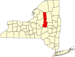
Millers Mills is a hamlet located in the Town of Columbia in Herkimer County, New York, United States.

The hamlet was founded by Andrew Miller and family, who built grist and saw mills there. He left all his sons 40 acre sections in the surrounding area for their homes. [2]

Related Research Articles

<span class="mw-page-title-main">Claverack, New York</span> Town in New York, United States

Claverack is a town in Columbia County, New York, United States. The population was 6,058 at the 2020 census. The town name in English was derived from the Dutch word Klaverakker, meaning "Clover Fields" or "Clover Reach". In 1705, a Dutch tenant farmer made the first discovery of a mastodon tooth here.

<span class="mw-page-title-main">Columbia, New York</span> Town in New York, United States

Columbia is a town in Herkimer County, New York, United States. As of the 2020 census, the town population was 1,569. The town is at the southern border of the county and is southeast of Utica.

<span class="mw-page-title-main">Annsville, New York</span> Town in New York, United States

Annsville is a town in Oneida County, New York, United States. At the 2010 census the town population was 3,012. The town is named after Ann Bloomfield, wife of a founder.

<span class="mw-page-title-main">Rifton, New York</span> CDP in New York, United States

Rifton is a hamlet in Ulster County, New York, United States. The population was 481 at the 2020 census.

<span class="mw-page-title-main">Arcadia, New York</span> Town in New York, United States

Arcadia is a town in Wayne County, New York, United States. The population was 14,244 at the 2010 census.

<span class="mw-page-title-main">Poughkeepsie (town), New York</span> Town in New York, United States

Poughkeepsie, officially the Town of Poughkeepsie, is a town in Dutchess County, New York, United States. As of the 2020 United States Census, the population was 45,471. The name is derived from the native compound Uppuqui-ipis-ing, from Uppuqui meaning "lodge-covered", plus ipis meaning "little water", plus ing meaning "place", all of which translates to "the reed-covered lodge by the little water place". This later evolved into Apokeepsing, then into Poughkeepsing, and finally Poughkeepsie.

<span class="mw-page-title-main">Milton, Saratoga County, New York</span> Town in New York, United States

Milton is a town in Saratoga County, New York, United States. The population was 18,800 at the 2020 census. Some believe that the town was named after the poet, John Milton, while other sources state that it is a shortening of "Mill-town" for the early mill activity.

<span class="mw-page-title-main">Unadilla River</span> River in New York, United States

The Unadilla River is a 71-mile-long (114 km) river in the Central New York Region of New York State. The river begins northeast of the hamlet of Millers Mills and flows generally south to the village of Sidney, where it converges with the Susquehanna River, which drains into the Chesapeake Bay, a bay of the Atlantic Ocean.

<span class="mw-page-title-main">Alley Spring, Missouri</span> Unincorporated community in Missouri, United States

Alley Spring is an unincorporated community in Shannon County, Missouri, United States. It is located six miles west of Eminence on Route 106. The scenic Alley Mill, or "Old Red Mill" is located there on a spring and is located in the Ozark National Scenic Riverways. The Mill is operated as an Ozarks history museum. Nearby a one room schoolhouse and general store add to the feeling of the restored historic hamlet. It once had a post office, but it is now closed and mail now comes from Eminence. The community is named after John Alley, a miller. It was originally named Mammoth Spring and later Barksdale Spring. These names were deemed too long by the Post Office Department of the time, so the village was renamed after a prominent local citizen, John Alley.

<span class="mw-page-title-main">New York's 1st congressional district</span> U.S. House district for New York

New York's 1st congressional district is a congressional district for the United States House of Representatives in eastern Long Island. It includes the eastern two-thirds of Suffolk County, including the northern portion of Brookhaven, as well as the entirety of the towns of Huntington, Smithtown, Riverhead, Southold, Southampton, East Hampton, and Shelter Island. The district encompasses extremely wealthy enclaves such as the Hamptons, middle class suburban towns such as Selden, Centereach, and Lake Grove, working-class towns such as Riverhead and rural farming communities such as Mattituck and Jamesport on the North Fork. The district currently is represented by Republican Nick LaLota.

<span class="mw-page-title-main">Mulino, Oregon</span> Unincorporated community in the state of Oregon, United States

Mulino, Oregon is a hamlet and census-designated place (CDP) located in Clackamas County, Oregon, United States, on Oregon Route 213 between the cities of Oregon City and Molalla. As of the 2010 census it had a population of 2,103.

Cunninghamhead is a hamlet on the Annick Water in the Parish of Dreghorn, North Ayrshire, Scotland. The area was part of the old Cunninghamhead estate, and once contained several watermills.

<span class="mw-page-title-main">Getzville, New York</span> Hamlet in New York, United States

Getzville is a hamlet in the town of Amherst in Erie County, New York, United States. Getzville's ZIP code is 14068, and its post office is located on Millersport Highway.

<span class="mw-page-title-main">Eastview, New York</span> Business district in New York, United States

Eastview is a business district and former hamlet in Mount Pleasant, Westchester County, New York, United States, located approximately 25 miles north of Midtown Manhattan. It was primarily residential, and had a post office, railroad station, and school. In the late 1920s, John D. Rockefeller Jr. purchased most of the hamlet's property and razed the buildings. The Hammond House, a National Register of Historic Places-listed farmhouse dating to the 1720s, is located in the district, on New York State Route 100C. Currently, dozens of commercial buildings have been developed in the area. The community is now most prominently known as the global headquarters for Regeneron Pharmaceuticals, which moved into a newly constructed campus in 2014.

Newton Falls is a hamlet of 400, located within Town of Clifton in Saint Lawrence County, New York, United States. The hamlet is located within the Adirondack Park. The area is known in part for its ZIP code, which is 13666.

<span class="mw-page-title-main">Saugerties, New York</span> Town in Ulster County, New York, United States

Saugerties is a town in the northeastern corner of Ulster County, New York. The population was 19,038 at the time of the 2020 Census, a decline from 19,482 in 2010. The village of the same name is located entirely within the town.

<span class="mw-page-title-main">Bloak</span> Human settlement in Scotland

Bloak was a hamlet or clachan in East Ayrshire, Parish of Stewarton, Scotland. The habitation was situated between Auchentiber and Stewarton on the B778. It was originally built as a row of housing for crofters and farm workers. The small school remained open for some years after the hamlet ceased to exist. Robinson gives the Scots word "blout" as meaning "an eruption of fluid", or a place that is soft or wet.

<span class="mw-page-title-main">Oaks Creek</span> River in New York State

Oaks Creek is a river that drains Canadarago Lake, which is situated in the north central region of Otsego County, New York. The creek begins by the Hamlet of Schuyler Lake and flows southeast approximately 9.32 miles (15.00 km), dropping only 105 feet (32 m) in elevation, before converging with the Susquehanna River south of the Village of Cooperstown, by the Hamlet of Index. From the source to Oaksville the creek flows along Panther Mountain. Fly Creek is a main tributary, that converges with Oaks Creek south of the Hamlet of Fly Creek.

Fly Creek also known as Vlaie Creek, begins by the border of the Town of Otsego and Town of Springfield in Otsego County, New York. Fly Creek then travels south towards the hamlet of Fly Creek and converges with Oaks Creek south of the hamlet of Fly Creek. The Fly Creek Cider Mill and Orchard is located next to Fly Creek. The Mill gets power to make cider from the Fly Creek water flow and is the last remaining mill in the area. Fly Creek is also located partly within the Fly Creek Historic District.

Millers Mills Crossing is a hamlet located in the Town of Columbia in Herkimer County, New York, United States.

References

  1. "Millers Mills". Geographic Names Information System . United States Geological Survey, United States Department of the Interior . Retrieved December 23, 2017.
  2. https://www.fold3.com/image/27173906/miller-john-page-55-us-revolutionary-war-pensions-1800-1900 [ bare URL ]