Millswood, South Australia

Last updated

Millswood
Adelaide,  South Australia
Millswood Crescent, Millswood.JPG
Millswood Crescent, looking towards the south-west
Population2,173 (SAL 2021) [1]
Postcode(s) 5034
Elevation44 m (144 ft)
Location5 km (3 mi) S of Adelaide
LGA(s) City of Unley
State electorate(s)
Federal division(s)
Suburbs around Millswood:
Forestville Forestville & Goodwood Unley
Black Forest Millswood Hyde Park
Clarence Park Clarence Park, Kings Park & Unley Park Unley Park

Millswood is an inner-southern mainly residential suburb of Adelaide in the City of Unley. It was named after Scotsman Samuel Mills, who arrived in the colony in 1839.

Contents

Description

The suburb is dissected by Goodwood Road, which travels north to the Adelaide city centre from the southern suburb of Pasadena. On the west side of Goodwood Road it is surrounded by the suburbs of Goodwood, Forestville, Black Forest and Clarence Park. On the east side of Goodwood Road it is surrounded by the suburbs of Goodwood, Hyde Park, Unley Park and Kings Park.

At the northern edge of the west side of the suburb, the Adelaide-Goodwood railway line forks with the Seaford railway line going south-west and the Belair railway line going south-east. Millswood railway station, located on the Belair line, on the southern edge of the suburb, was closed in 1995 but reopened in 2014. [2]

Goodwood Road passes under the railway line in a deep underpass, known as the Goodwood Subway, which often floods during heavy rain.

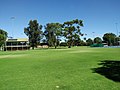
Within the triangle formed by the railway fork and Millswood Crescent are the SASMEE ( South Australian Society of Model & Experimental Engineers) Park [3] and the Millswood croquet, lawn bowls and lawn tennis clubs. The Goodwood Oval and grandstand, with playground, barbeque facilities, soccer pitch and grandstand, cricket practice nets, and eight hard tennis courts, are located to the west of the fork in the railway line.

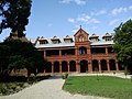
The former Goodwood Orphanage and the surrounding Orphanage Park are located on the south-east corner of Goodwood Road and Mitchell Street and now houses Tabor College Australia. [4]

History

Millswood was named after Scotsman Samuel Mills, who arrived in the colony in 1839 and owned a property called Ravenswood Farm. [5]

In 1917, Hackett's Nursery, a family-run business then in Marryatville, was sold to a limited company, E. & W. Hackett Limited, with the Hacketts continuing as directors. In the same year the business bought a 6-acre (2.4 ha) plot [6] in the Millswood Estate for over £20,067 [7] to accommodate the nursery, [8] which drew glowing praise in a 1923 newspaper article [6] and continued to do business there until 1952. [5]

Related Research Articles

<span class="mw-page-title-main">Goodwood railway station</span> Railway station in Adelaide, South Australia

Goodwood railway station is the junction station for the Belair, Seaford and Flinders lines. The Belair line diverges south-east towards Millswood, while the Seaford and Flinders lines diverge south-west towards Clarence Park. The Glenelg tram line crosses over the railway lines at the south end of Goodwood station. The station services the Adelaide inner-southern suburb of Goodwood, and is 5.0 km from Adelaide station.

<span class="mw-page-title-main">Belair, South Australia</span> Suburb of Adelaide, South Australia

Belair is a suburb in the south eastern foothills of Adelaide, South Australia at the base of the Mount Lofty Ranges.

<span class="mw-page-title-main">Goodwood, South Australia</span> Suburb of Adelaide, South Australia

Goodwood is an inner southern suburb of the city of Adelaide, South Australia. It neighbours the Royal Adelaide Showgrounds and features several churches in its commercial district. Its major precinct is Goodwood Road, which is home to many shops, businesses and a library, as well as the local state school.

<span class="mw-page-title-main">Colonel Light Gardens, South Australia</span> Suburb of Adelaide, South Australia

Colonel Light Gardens is a suburb located within the Australian City of Mitcham in the greater Adelaide region, approximately 7 km (4 mi) south of the Adelaide city centre. The area is 1.58 km2 (0.61 sq mi). Planned as a garden suburb, it is known for wide, tree-lined streets, presentable postwar bungalow homes, rounded street corners, and much manicured, well maintained open space.

<span class="mw-page-title-main">City of Mitcham</span> Local government area in South Australia

The City of Mitcham is a local government area in the foothills of southern Adelaide, South Australia. Within its bounds is Flinders University, South Australia's third largest, and the notable, affluent suburb of Springfield which contains some of the city's most expensive properties.

<span class="mw-page-title-main">Millswood railway station</span> Railway station in Adelaide, South Australia

Millswood railway station is located on the Belair line in Adelaide. Situated in the Adelaide suburb of Millswood, it is 5.9 kilometres (3.7 mi) from Adelaide station.

<span class="mw-page-title-main">Hawthorn railway station, Adelaide</span> Railway station in Adelaide, South Australia

Hawthorn railway station was located on the Belair line, in the inner southern Adelaide suburb of Hawthorn, 7.5 kilometres from Adelaide railway station.

<span class="mw-page-title-main">Clapham railway station, Adelaide</span> Former railway station in South Australia, Australia

Clapham railway station was located on the Belair line in the inner southern Adelaide suburb of Clapham, 10 kilometres (6.2 mi) from Adelaide railway station.

<span class="mw-page-title-main">Unley, South Australia</span> Suburb of Adelaide, South Australia

Unley is an inner-southern suburb of Adelaide, South Australia, within the City of Unley. The suburb is the home of the Sturt Football Club in the South Australian National Football League (SANFL). Unley neighbours Adelaide Park Lands, Fullarton, Hyde Park, Malvern, Parkside and Wayville.

Westbourne Park is an inner southern suburb of Adelaide, the State capital of South Australia. The suburb was named after Westbourne, a village in Sussex, England, and was laid out in 1881.

<span class="mw-page-title-main">Belair line</span> Rail line in Adelaide, South Australia

The Belair line is a suburban rail commuter route in the city of Adelaide, South Australia, that runs from the Adelaide station to Belair in the Adelaide Hills via the Adelaide-Wolseley line using diesel 3000/3100 class railcars. Prior to 1995, this part of Adelaide-Wolseley was a two-track broad gauge line. In 1995, Adelaide-Wolseley was converted to standard gauge meaning Adelaide to Belair is now effectively two separate single-track lines running in parallel: the Belair commuter line and the Adelaide-Wolseley standard gauge freight line.

<span class="mw-page-title-main">Clarence Park, South Australia</span> Suburb of Adelaide, South Australia

Clarence Park is an inner southern suburb of Adelaide, South Australia in the City of Unley. Its borders are Mills Street (north), Goodwood Road (east), Cross Road (south) and the Seaford railway line (north-west).

Hyde Park is an affluent inner-southern suburb of Adelaide in the City of Unley.

Kings Park is a small, triangular-shaped suburb of Adelaide. It is the most tightly held suburb in South Australia with a turnover of properties of just 1.3 percent. Located in the City of Unley it is serviced by both the Millswood railway station on the northern boundary of the suburb and the Unley Park railway station on the southeast corner of the suburb.

<span class="mw-page-title-main">Unley Park, South Australia</span> Suburb of Adelaide, South Australia

Unley Park is a southern suburb of Adelaide in the City of Unley. Its postcode is 5061.

Marryatville is a small suburb about 4–5 kilometres (2.5–3.1 mi) east of Adelaide's central business district, in the local council area of City of Norwood Payneham St Peters. Comprising low- to medium-density housing, two large schools, a church and several shops, it also has two creeks running through it. The first European settler on the land was George Brunskill in 1839, with part of the land purchased and laid out as a village in 1848 by James Philcox.

<span class="mw-page-title-main">Goodwood Road, Adelaide</span> Road in Adelaide, South Australia

Goodwood Road is a major north–south arterial road, approximately 10 kilometres long, in Adelaide, South Australia. It runs between the Adelaide city centre and Adelaide's southern suburbs of Pasadena and Panorama.

<span class="mw-page-title-main">Electoral district of Unley</span> State electoral district of South Australia

Unley is a single-member electoral district for the South Australian House of Assembly. Named after the suburb of the same name, it is the state's smallest electorate by area at just 14.1 km2 (5.4 sq mi). It is a suburban electorate in Adelaide's inner south, taking in the suburbs of Eastwood, Frewville, Fullarton, Glenside, Glenunga, Goodwood, Highgate, Hyde Park, Kings Park, Malvern, Myrtle Bank, Parkside, Unley, Unley Park and Wayville, as well as parts of Glen Osmond and Millswood.

<span class="mw-page-title-main">Cross Road, Adelaide</span> Arterial road in Adelaide, South Australia

Cross Road is a major arterial road that travels east–west through the inner southern suburbs of the Australian city of Adelaide. It is designated route A3.

<span class="mw-page-title-main">Bridgewater railway line</span>

The Bridgewater railway line is a former passenger railway service on the Adelaide to Wolseley line in the Adelaide Hills. It was served by suburban services from Adelaide. On 26 July 1987, the service was curtailed to Belair and renamed Belair railway line. In 1995, the Adelaide-Wolseley line was converted to standard gauge as part of the One Nation infrastructure program, disconnecting the abandoned Bridgewater line stations from the broad gauge suburban railway system.

References

  1. Australian Bureau of Statistics (28 June 2022). "Millswood (suburb and locality)". Australian Census 2021 QuickStats. Retrieved 28 June 2022.  OOjs UI icon edit-ltr-progressive.svg
  2. http://www.adelaidenow.com.au/messenger/east-hills/millswood-train-station-is-set-to-remain-open-permanently-after-a-successful-year-long-trial/story-fni9lkyu-1227571788017?sv=e2ad48e8c777ce77b47c4e544171bb17&nk=73c2ac11b20cf2a1fcda6c99c42553b4-1466231686 [ bare URL ]
  3. SASMEE – The South Australian Society of Model & Experimental Engineers, www.sasmee.com.au
  4. History, www.goodwoodroad.com.au
  5. 1 2 McDougall & Vines (2006). "Unley Heritage Research Study for the City of Unley: Volume I" (PDF). Retrieved 26 July 2019.
  6. 1 2 "Hackett's Nursery". The Journal (Adelaide) . Vol. LVI, no. 15420. South Australia. 7 May 1921. p. 15 (Night Edition). Retrieved 25 July 2019 via National Library of Australia.
  7. "The Millswood Estate". The Mail (Adelaide) . Vol. 6, no. 279. South Australia. 22 September 1917. p. 4. Retrieved 26 July 2019 via National Library of Australia.
  8. "An Old-Time Garden". The Observer (Adelaide) . Vol. LXXX, no. 5, 960. South Australia. 21 April 1923. p. 41. Retrieved 25 July 2019 via National Library of Australia.

34°57′22″S138°35′24″E / 34.956°S 138.590°E / -34.956; 138.590