Milo, Kansas

Last updated
Milo, Kansas
Map of Lincoln Co, Ks, USA.png
USA Kansas location map.svg
Red pog.svg
Milo
Usa edcp location map.svg
Red pog.svg
Milo
Coordinates: 39°10′20″N97°58′03″W / 39.17222°N 97.96750°W / 39.17222; -97.96750 [1]
Country United States
State Kansas
County Lincoln
Elevation
[1]
1,299 ft (396 m)
Population
  Total0
Time zone UTC-6 (CST)
  Summer (DST) UTC-5 (CDT)
Area code 785
FIPS code 20-46850 [1]
GNIS ID 484773 [1]

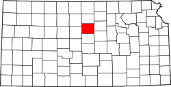
Milo is a ghost town in Lincoln County, Kansas, United States. [1] It was located along a former railroad about halfway between the communities of Barnard and Ada.

Contents

History

Milo was issued a post office in 1872. The post office was discontinued in 1938. [2]

The 1912 cyclopedia of Kansas describes Milo as a "country trading point" on Atchison, Topeka and Santa Fe Railway, with "2 stores, an express office, and a money order postoffice with one rural route." It reported the 1910 population to be 50 people. [3]

The referenced rail line opened in 1888 as a line of the Chicago, Kansas and Western Railroad opened from Manchester in the east to Barnard in the west, a 43 mile line, with a stop at Milo. The Atchison, Topeka and Santa Fe Railway the line in 1901. [4] An application was filed in 1983 to abandon this "Minneapolis District" line. [5]

Related Research Articles

<span class="mw-page-title-main">Marion County, Kansas</span> County in Kansas, United States

Marion County is a county located in the U.S. state of Kansas. Its county seat is Marion and its most populous city is Hillsboro. As of the 2020 census, the county population was 11,823. The county was named in honor of Francis Marion, a brigadier general of the American Revolutionary War, known as the "Swamp Fox".

<span class="mw-page-title-main">Hackney, Kansas</span> Unincorporated community in Cowley County, Kansas

Hackney is an unincorporated community in Cowley County, Kansas, United States.

Huscher is an unincorporated community in Cloud County, Kansas, United States.

<span class="mw-page-title-main">Kackley, Kansas</span> Unincorporated community in Republic County, Kansas

Kackley is an unincorporated community in Republic County, Kansas, United States. It is located southeast of Courtland at Co Rd 5 and K-148 highway.

Brazilton is an unincorporated community in Crawford County, Kansas, United States. It located along highway K-3.

<span class="mw-page-title-main">Paul P. Hastings</span>

Paul Pardee Hastings was a prominent executive of the Atchison, Topeka, and Santa Fe Railroad.

<span class="mw-page-title-main">Mitchell, Kansas</span> Unincorporated community in Rice County, Kansas

Mitchell is an unincorporated community in Rice County, Kansas, United States. Located about 6 miles (9.7 km) east-northeast of the city of Lyons, it lies along local roads a fraction of a mile north of U.S. Route 56.

<span class="mw-page-title-main">Gordon, Kansas</span> Unincorporated community in Butler County, Kansas

Gordon is an unincorporated community in Butler County, Kansas, United States.

Buxton is an unincorporated community in Wilson County, Kansas, United States.

Grand Summit is an unincorporated community in Cowley County, Kansas, United States.

Agricola is an unincorporated community in Coffey County, Kansas, United States. It is located along Old Highway 50 and 27th Rd.

Charleston is an unincorporated community in Gray County, Kansas, United States. It is located along Highway 50.

<span class="mw-page-title-main">Dalton, Kansas</span> Unincorporated community in Sumner County, Kansas

Dalton is an unincorporated community in Avon Township, Sumner County, Kansas, United States. It is located about halfway between Wellington and Oxford at the intersection of S Oliver Rd and E 15th St S, next to an abandoned railroad.

Darlow is an unincorporated community in Lincoln Township, Reno County, Kansas, United States. It is located several miles west of Yoder along Red Rock Road.

<span class="mw-page-title-main">De Graff, Kansas</span> Unincorporated community in Butler County, Kansas

De Graff is an unincorporated community in Butler County, Kansas, United States. It is located on U.S. Route 77 approximately 7.7 miles (12.4 km) north of I-35

<span class="mw-page-title-main">Plymouth, Kansas</span> Unincorporated community in Lyon County, Kansas

Plymouth is an unincorporated community in Lyon County, Kansas, United States. It is located approximately 5 miles west of the city of Emporia along Rd B2.

<span class="mw-page-title-main">Oursler, Kansas</span> Ghost town in Marion County, Kansas

Oursler is a ghost town in Marion County, Kansas, United States. It is currently a ghost town that was located approximately 3.5 miles southeast of Marion next to a former railroad. No buildings remain of this former community.

Homewood is a unincorporated community in Homewood Township, Franklin County, Kansas, United States. In the 19th century it had a post office and a stop on the Atchison, Topeka, and Santa Fe Railway.

Vine Creek is a ghost town in Ottawa County, Kansas, United States.

<span class="mw-page-title-main">Cairo, Kansas</span> Unincorporated community in Pratt County, Kansas

Cairo is an unincorporated community in Pratt County, Kansas, United States. It is located between the cities of Pratt and Cunningham, roughly 11 miles east of Pratt.

References

  1. 1 2 3 4 5 "Milo, Kansas", Geographic Names Information System , United States Geological Survey, United States Department of the Interior
  2. "Kansas Post Offices, 1828-1961". Kansas Historical Society. Retrieved 2018-01-05.[ permanent dead link ]
  3. Kansas, A Cyclopedia ..., Vol. II, p. 285 (1912)
  4. Gannett, Henry (1898). A Gazetteer of Kansas. Govt. Print. Off. p. 23.
  5. The Minneapolis District, Abandoned Rails, Retrieved 21 February 2022

Further reading