Mims, Florida

Last updated • 4 min readFrom Wikipedia, The Free Encyclopedia

Mims, Florida
Unincorporated census-designated place
Brevard County Florida Incorporated and Unincorporated areas Mims Highlighted.svg
Location in Brevard County and Florida
Coordinates: 28°40′7″N80°50′53″W / 28.66861°N 80.84806°W / 28.66861; -80.84806
Country Flag of the United States.svg United States
State Flag of Florida.svg  Florida
County Flag of Brevard County, Florida.svg Brevard
Area
[1]
  Total
22.37 sq mi (57.93 km2)
  Land17.07 sq mi (44.21 km2)
  Water5.30 sq mi (13.72 km2)
Elevation
33 ft (10 m)
Population
 (2020)
  Total
7,336
  Density429.76/sq mi (165.93/km2)
Time zone UTC-5 (Eastern (EST))
  Summer (DST) UTC-4 (EDT)
ZIP code
32754
Area code 321
FIPS code 12-45775 [2]
GNIS feature ID0286950 [3]

Mims is a census-designated place (CDP) holding the single zip code 32754 located within Brevard County, Florida, United States. The population was 7,336 at the 2020 census. [4] It is part of the Palm Bay—Melbourne—Titusville Metropolitan Statistical Area.

Contents

Geography

Mims is located at 28°40′7″N80°50′53″W / 28.66861°N 80.84806°W / 28.66861; -80.84806 (28.668670, −80.847949). [5]

According to the United States Census Bureau, the CDP has a total area of 22.4 square miles (57.9 km2), of which 17.0 square miles (44.1 km2) is land and 5.3 square miles (13.7 km2), or 23.71%, is water. [6]

Demographics

Historical population
CensusPop.Note
1990 9,412
2000 9,147−2.8%
2010 7,058−22.8%
2020 7,3363.9%
U.S. Decennial Census [7]

As of the census [2] of 2000, there were 9,147 people, 3,591 households, and 2,574 families residing in the CDP. The population density was 462.0 inhabitants per square mile (178.4/km2). There were 4,171 housing units at an average density of 210.7 per square mile (81.4/km2). The racial makeup of the CDP was 86.57% White, 10.98% African American, 0.63% Native American, 0.22% Asian, 0.02% Pacific Islander, 0.26% from other races, and 1.31% from two or more races. Hispanic or Latino of any race were 1.54% of the population.

There were 3,591 households, out of which 28.6% had children under the age of 18 living with them, 55.6% were married couples living together, 11.4% had a female householder with no husband present, and 28.3% were non-families. 22.8% of all households were made up of individuals, and 10.8% had someone living alone who was 65 years of age or older. The average household size was 2.52 and the average family size was 2.95.

In the CDP, the population was spread out, with 24.0% under the age of 18, 6.2% from 18 to 24, 26.4% from 25 to 44, 25.6% from 45 to 64, and 17.8% who were 65 years of age or older. The median age was 41 years. For every 100 females, there were 98.3 males. For every 100 females age 18 and over, there were 95.9 males.

Economy

Personal income

The median income for a household in the CDP was $35,216, and the median income for a family was $41,044. Males had a median income of $33,886 versus $21,925 for females. The per capita income for the CDP was $17,433. About 11.3% of families and 15.6% of the population were below the poverty line, including 20.5% of those under age 18 and 12.4% of those age 65 or over.

Industry

Praxair in Mims produces liquid oxygen for the Kennedy Space Center. [8]

History

Mims, Florida received its name after its earliest settlers; Britton J. Mims, Robert Mims, and Casper Neil Mims. The three brothers were reputedly distant relatives to Jesse James. Casper later established the first Mims general store circa 1876. [9]

Henry Flagler's East Coast Railroad construction starting 1885 expanded the community. By 1893, with railroad in place, both Mims and neighboring city Titusville began shipping citrus and lumber to northern cities. [10] By the end of the 19th century citrus farms began to dominate the local economy. [11]

The settlement was organized as a city in the early 1900s; continuing slow growth until the start of the great depression. During the first years of the great depression large numbers of residents reportedly left looking for work. Mims, unable to sustain a municipal government, subsequently reverted to an unincorporated township within Brevard County, Florida.

Murders of Harry and Harriette Moore

African-American civil rights leader Harry T. Moore and his family resided in Mims from at least the 1920s. Known as a national civil rights leader, teacher and founder of the Brevard County NAACP, he and his wife Harriette were targeted for assassination Christmas Eve, 1951; they received fatal injuries when a bomb exploded from under their home. Moore died in the blast; his wife survived until January 3, 1952 . Both of their daughters survived the attack. The murders were racially motivated and believed to have been committed by members of the Ku Klux Klan.

The FBI investigated the case in 1951–1952, and the county and state in the 1970s and 1990s. The state reinvestigated in 2005, after suspected perpetrators had died. No prosecutions or charges were ever brought against the purpetrator(s). [12] [13] Multiple sites in Mims and Brevard County are dedicated to the Moores including the Moore Memorial Park and Cultural Center in Mims.

Education

There are three schools, one adult education center, and one childcare center located in Mims; two public and three private.

Notable people

Related Research Articles

Kaibab is an unincorporated community and census-designated place (CDP) in Mohave County, Arizona, United States. It is within the Kaibab Indian Reservation. The population of the CDP was 140 at the 2020 census.

<span class="mw-page-title-main">Cocoa West, Florida</span> CDP in Florida, United States

Cocoa West is a census-designated place (CDP) in Brevard County, Florida, United States. The population was 5,939 at the 2020 census, up from 5,925 at the 2010 census. It is the closest place to Lake Poinsett and Canaveral Groves. Cocoa West is part of the Palm Bay–Melbourne–Titusville, Florida Metropolitan Statistical Area.

<span class="mw-page-title-main">Indialantic, Florida</span> Town in the state of Florida, United States

Indialantic is a town in Brevard County, Florida. It is part of the Palm Bay–Melbourne–Titusville, Florida Metropolitan Statistical Area. The town's population was 3,010 at the 2020 United States Census, up from 2,720 at the 2010 census.

<span class="mw-page-title-main">June Park, Florida</span> Census-designated place in Florida

June Park is a census-designated place (CDP) in Brevard County, Florida. The population was 4,283 at the 2020 United States census, up from 4,094 at the 2010 United States Census. It is part of the Palm Bay–Melbourne–Titusville, Florida Metropolitan Statistical Area.

<span class="mw-page-title-main">Merritt Island, Florida</span> Census-designated place in Florida, United States

Merritt Island is a peninsula, commonly referred to as an island, in Brevard County, Florida, United States, located on the eastern Florida coast, along the Atlantic Ocean. It is also the name of an unincorporated town in the central and southern parts of the island and a census-designated place (CDP).

<span class="mw-page-title-main">Micco, Florida</span> Census-designated place in Florida

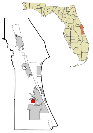
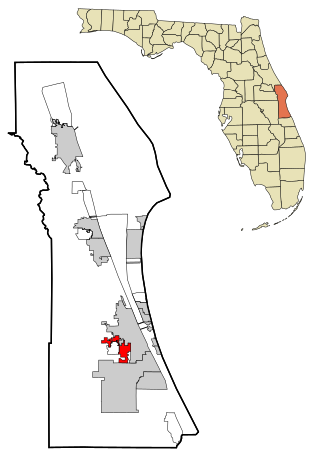
Micco is a census-designated place (CDP) in Brevard County, Florida. The population was 9,574 at the 2020 United States census, up from 9,052 at the 2010 United States Census. It is part of the Palm Bay–Melbourne–Titusville, Florida Metropolitan Statistical Area.

<span class="mw-page-title-main">Port St. John, Florida</span> Census-designated place in Florida

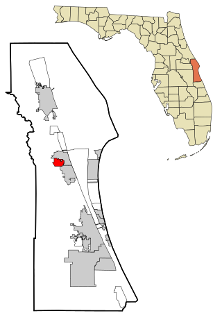
Port St. John is a census-designated place located between Titusville and Cocoa in Brevard County, Florida. The population was 23,474 at the 2020 United States Census, up from 12,267 at the 2010 United States Census. It is part of the Palm Bay–Melbourne–Titusville, Florida Metropolitan Statistical Area.

<span class="mw-page-title-main">Sharpes, Florida</span> Census-designated place in Florida

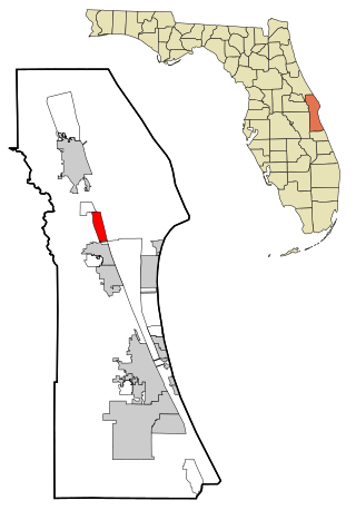
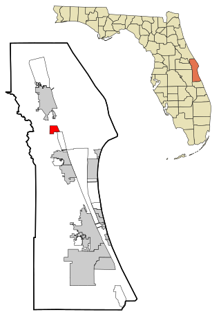
Sharpes is a census-designated place (CDP) in Brevard County, Florida. The population was 3,115 at the 2020 United States census, down from 3,411 at the 2010 United States Census. It is part of the Palm Bay–Melbourne–Titusville, Florida Metropolitan Statistical Area.

<span class="mw-page-title-main">South Patrick Shores, Florida</span> CDP in Florida, United States

South Patrick Shores is a census-designated place (CDP) in Brevard County, Florida, United States. The population was 6,496 at the 2020 census, up from 5,875 at the 2010 census. It is part of the Palm Bay–Melbourne–Titusville, Florida Metropolitan Statistical Area.

<span class="mw-page-title-main">Titusville, Florida</span> City in Florida, United States

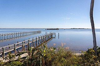
Titusville is a city in and the county seat of Brevard County, Florida, United States. As of the 2020 census, the population of the city was 48,789, up from 43,761 at the 2010 census. Titusville is located along the Indian River, west of Merritt Island and the Kennedy Space Center, and south-southwest of the Canaveral National Seashore. It is a principal city of the Palm Bay–Melbourne–Titusville, Florida Metropolitan Statistical Area.

<span class="mw-page-title-main">West Melbourne, Florida</span> City in Florida

West Melbourne is a city in Brevard County, Florida, United States. It was created in 1959 to stop the area from being annexed into the city of Melbourne. Since 2000, the city has experienced the highest population growth percentage of any municipality in Brevard County. It is part of the Palm Bay–Melbourne–Titusville, Florida Metropolitan Statistical Area. As of the 2020 US Census, the population was 25,924, up from 18,355 at the 2010 census.

<span class="mw-page-title-main">Roseland, Florida</span> Census-designated place in Florida, United States

Roseland is an unincorporated community and census-designated place (CDP) in Indian River County, Florida, United States. The population was 1,472 at the 2010 census, down from 1,775 at the 2000 census. It is part of the Sebastian–Vero Beach Metropolitan Statistical Area.

<span class="mw-page-title-main">Sorrento, Florida</span> Census-designated place in Florida

Sorrento is an unincorporated community and census-designated place in Lake County, Florida, United States. The population was 861 at the 2010 census, up from 765 at the 2000 census. It is part of the Orlando–Kissimmee Metropolitan Statistical Area.

<span class="mw-page-title-main">Ives Estates, Florida</span> Census-designated place in Florida

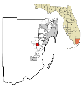
Ives Estates is a census-designated place (CDP) in Miami-Dade County, Florida. It is part of the Miami metropolitan area of South Florida. The population was 25,005 at the 2020 census, up from 19,525 in 2010.

<span class="mw-page-title-main">Three Lakes, Florida</span> Census-designated place in Florida

Three Lakes is a census-designated place (CDP) and planned community in Miami-Dade County, Florida, United States. It is part of the Miami metropolitan area of South Florida. The population was 16,540 at the 2020 census, up from 15,047 in 2010.

<span class="mw-page-title-main">Westview, Florida</span> Census-designated place in Florida

Westview is a census-designated place (CDP) in Miami-Dade County, Florida, United States. It is part of the Miami metropolitan area of South Florida. The population was 9,923 at the 2020 census.

<span class="mw-page-title-main">Fairview Shores, Florida</span> Census-designated place in Florida, United States

Fairview Shores is a census-designated place and an unincorporated area in Orange County, Florida, United States. The population was 10,239 at the 2010 census. It is part of the Orlando–Kissimmee–Sanford, Florida Metropolitan Statistical Area.

<span class="mw-page-title-main">Parc, New York</span> Census-designated place in New York, United States

Parc is a location and census-designated place in Clinton County, New York, United States. The name "Parc" is derived from the official name for the 3,447-acre (13.95 km2) industrial site, which is PARC, an acronym for the Plattsburgh Airbase Redevelopment Corporation. PARC was established for the purpose of redeveloping the Plattsburgh Air Force Base after it closed on September 25, 1995. PARC is now operated by the Plattsburgh Air Base Development Authority, and the massive airfield is now Plattsburgh International Airport. The population of the Parc CDP was 254 at the 2010 census. Parc is located in the town of Plattsburgh and is bordered to the north by the city of Plattsburgh.

<span class="mw-page-title-main">Goldens Bridge, New York</span> Census-designated place in New York, United States

Goldens Bridge is a hamlet and census-designated place (CDP) in the town of Lewisboro in Westchester County, New York, United States. The population was 1,630 at the 2010 census.

<span class="mw-page-title-main">Turnerville, Wyoming</span> Census-designated place in Wyoming, United States

Turnerville is a census-designated place (CDP) in Lincoln County, Wyoming, United States. The population was 192 at the 2010 census.

References

  1. "2020 U.S. Gazetteer Files". United States Census Bureau. Retrieved October 31, 2021.
  2. 1 2 "U.S. Census website". United States Census Bureau . Retrieved January 31, 2008.
  3. "US Board on Geographic Names". United States Geological Survey. October 25, 2007. Retrieved January 31, 2008.
  4. "Profile of General Population and Housing Characteristics: 2010 Demographic Profile Data (DP-1): Mims CDP, Florida". United States Census Bureau . Retrieved January 31, 2012.
  5. "US Gazetteer files: 2010, 2000, and 1990". United States Census Bureau. February 12, 2011. Retrieved April 23, 2011.
  6. "Geographic Identifiers: 2010 Demographic Profile Data (G001): Mims CDP, Florida". United States Census Bureau . Retrieved January 31, 2012.
  7. "Census of Population and Housing". Census.gov. Retrieved June 4, 2016.
  8. "Article: Praxair awarded five-year contract.(Praxair Inc.)(United States. National Aeronautics and Space Administration)(Brief article)". Fairfield County Business Journal. highbeam.com. June 26, 2006. Archived from the original on November 4, 2012.
  9. Brotemarkle, B, 2004. Images of America: Titusville and Mims. p. 21. Charleston, SC: Arcadia Publishing.
  10. Brotemarkle, p. 22
  11. "Mims, Florida". Florida Backroads Travel.
  12. "Freedom Never Dies: The Legacy of Harry T. Moore". PBS. p. Florida Terror: Who Killed Harry T. Moore. Retrieved March 27, 2014.
  13. "Crist Announces Results of Harry T. Moore Murder Investigation", 16 Aug 2006 Archived 2007-01-06 at the Wayback Machine , accessed 6 May 2008