Schlater is a town in Leflore County, Mississippi, United States. The population was 310 at the 2010 census, down from 388 at the 2000 census. It is part of the Greenwood, Mississippi micropolitan area.
Mississippi Highway 555 is a state highway in southwestern Mississippi. The route has two sections, both in Adams County. The first section starts at Ogden Road and travels northwestward to its terminus at US 61. The second section starts at the concurrency of MS 930 and MS 932 and the concurrency of US 61 and US 84 in Natchez. MS 555 travels northward through Pine Ridge and ends at Anna's Bottom Road near the Anna Site. The route travels by a few historical locations, including the Pine Ridge Presbyterian Church.
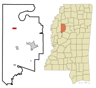
Mississippi Highway 3 is a north–south Mississippi state highway, located entirely within the Mississippi Delta region, running from Redwood to Lake Cormorant, both at an intersection with U.S. Route 61. For much of its duration, MS 3 is overlapped (concurrent) with U.S. Route 49W. It travels approximately 192 miles (309 km), serving DeSoto, Tunica, Tate, Panola, Quitman, Tallahatchie, Sunflower, Humphreys, Yazoo, and Warren counties.
Mississippi Highway 8 is an east–west state highway in northern Mississippi, running 168.1 miles (270.5 km) from MS 1 in Rosedale to U.S. Route 278 northeast of Aberdeen. Points of interest along the route include Great River Road State Park, Delta State University, Grenada Lake, Hugh White State Park, and the Natchez Trace Parkway.
U.S. Route 49W is an 89.3-mile-long (143.7 km) U.S. Highway in the Delta region of Mississippi, passing through Yazoo, Humphreys, Sunflower, and Tallahatchie counties.
Mississippi Highway 35 is a state highway in Mississippi. It runs north–south for 274.7 miles (442.1 km), beginning at the Louisiana state line and ending at a junction with MS 315 at Sardis Dam. MS 35 serves the counties of Marion, Jefferson Davis, Covington, Smith, Scott, Leake, Attala, Carroll, Grenada, Tallahatchie, and Panola.
Mississippi Highway 32 is a state highway in northern Mississippi it runs from east to west for 152.0 miles (244.6 km), serving the counties of Bolivar, Sunflower, Tallahatchie, Yalobusha, Calhoun, and Chickasaw. The publicly accessible portion of MS 32 is divided into two sections, the first of which begins near Perthshire and runs eastward to the rear entrance of the Mississippi State Penitentiary (MSP). The second section begins at the main entrance of MSP and runs eastward to MS 32's terminus in Okolona. A private portion of MS 32 runs from the main entrance of MSP to the rear entrance of MSP.
Mississippi Highway 24 is a state highway in Mississippi, United States. The highway runs 76.0 miles (122.3 km) from Fort Adams east to an interchange with Interstate 55 (I-55) and U.S. Highway 98 in McComb. The roadway passes through Wilkinson, Amite, and Pike counties, serving the communities of Woodville, Centreville, Gloster, and Liberty. MS 24 has concurrencies with MS 33 between Centerville and Gloster and MS 48 from Liberty to west of McComb.
Mississippi Highway 149 is a state highway in Mississippi. The route designation is given to six former segments of U.S. Route 49, and two former sections of US 49W, within the state that have been bypassed. The sections run through Wiggins, Mount Olive, between Magee and Sanatorium, between Mendenhall and Braxton, in Richland, Mississippi, between Yazoo City and Silver City, Inverness, and Clarksdale. The total length of the eight sections of MS 149 is 58.073 miles (93.459 km).
Mississippi Highway 161 (MS 161) is a state highway designation for three highways in the U.S. state of Mississippi, consisting of old alignments of U.S. Route 61 (US 61). Totaling at 19.872 miles (31.981 km), the three sections are located in Bolivar, Coahoma, and Desoto counties. The Bolivar County section, designated in 2000, travels from Merigold to Mound Bayou and Shelby. In Coahoma County, MS 161 was designated in 2004 and runs through Clarksdale and Lyon. In Desoto County, MS 161 travels through the town of Walls and was created in 1999.
Mississippi Highway 438 is a state highway in western Mississippi. The route starts at MS 1 in Wayside and travels eastward. The road travels through farmland and intersects U.S. Route 61 and its old alignment near Arcola. MS 438 continues eastward and ends at Sunflower River Road and Kinlock Road on the Washington–Sunflower county line near Kinlock. The route was constructed around 1950, connecting from MS 1 to US 61. The route was extended to the Washington–Sunflower county line by 1958, and to US 49W in Inverness by 1960. The section east of the county line was removed from the route by 1974.
Mississippi Highway 436 is a state highway in western Mississippi. The route starts at Eastside Lake Washington Road in Glen Allan and travels eastward. The road intersects MS 1 in Hampton and turns northeastward. It ends near Percy at U.S. Route 61. MS 436 was designated in 1957, along a road from US 61 to a point near the Washington–Sharkey county line. The route was extended westward to Glen Allan along a state-maintained road in 1958, and also eastward to Belzoni via a county road in 1967. The route east of US 61 was decommissioned by 1967.
Mississippi Highway 609 is a 20.5-mile-long (33.0 km) north-south state highway in Jackson County in the Mississippi Gulf Coast region of Mississippi, consisting of two sections. The first is signed along Washington Avenue between US Highway 90 (US 90) and Interstate 10 (I-10), and the second is unsigned and continues north from Latimer at Old Biloxi Road to Vestry Road in Vestry.
Mississippi Highway 618 is a 4.91-mile-long (7.90 km) unsigned east-west state highway in Jackson County in the Mississippi Gulf Coast region of Mississippi. It connects the city of Moss Point to the community of Orange Grove.
Mississippi Highway 433 (MS 433) is a state highway in western Mississippi consisting of two segments. The western segment, running entirely in Sharkey County is unsigned and runs for about 10.5 miles (16.9 km). The eastern segment, at a length of 45.3 miles (72.9 km), runs from Satartia in Yazoo County to rural Holmes County.
Mississippi Highway 503 (MS 503) is a 41-mile-long (66 km) state highway in eastern Mississippi running from MS 528 near its junction with Interstate 59 (I-59) outside of Heidelberg to MS 15 in Decatur. The highway has been in existence since 1951 and became designated MS 503 by 1955.
Mississippi Highway 583 (MS 583) is a state highway in southern Mississippi that runs just under 40 miles (64 km) in length. The road was designated in 1956 and runs from MS 27 in Tylertown to MS 184 in Brookhaven.
Mississippi Highway 407 (MS 407) is a two-lane wide state highway in central Mississippi consisting of two separate segments. The first segment connects the towns of McCool and Weir with MS 12 and is signed a north-south route. The second segment runs from French Camp at MS 413 west to Winona at U.S. Route 51 (US 51). Most of the road is state maintained, however, a 5.5-mile-long (8.9 km) segment between McCool and Weir are maintained as county roads.
Mississippi Highway 540 (MS 540) is a state highway through Simpson and Smith counties in central Mississippi. First created in 1958, the highway consists of two segments- one running about 10+1⁄2 miles (16.9 km) from Harrisville to D'Lo and a second 21.7-mile-long (34.9 km) road from Mendenhall to Raleigh.
Mississippi Highway 448 (MS 448) is a state highway through the Mississippi Delta region of Mississippi. Traveling through Bolivar and Smith counties, it travels for about 31 miles (50 km) through the agricultural fields of the Delta.


