Schlater, Mississippi

Last updated

Schlater, Mississippi
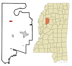
Leflore County Mississippi Incorporated and Unincorporated areas Schlater Highlighted.svg
Location of Schlater, Mississippi
Usa edcp location map.svg
Red pog.svg
Schlater, Mississippi
Location in the United States
Coordinates: 33°38′23″N90°20′58″W / 33.63972°N 90.34944°W / 33.63972; -90.34944
Country United States
State Mississippi
County Leflore
Government
  TypeMayor and board of aldermen
Area
[1]
  Total
1.15 sq mi (2.99 km2)
  Land1.15 sq mi (2.99 km2)
  Water0.00 sq mi (0.00 km2)
Elevation
[2]
131 ft (40 m)
Population
 (2020)
  Total
236
  Density204.51/sq mi (78.95/km2)
Time zone UTC-6 (Central (CST))
  Summer (DST) UTC-5 (CDT)
ZIP code
38952
Area code 662
FIPS code 28-66080
GNIS feature ID2407296 [2]

Schlater is a town in Leflore County, Mississippi, United States. The population was 310 at the 2010 census, [3] down from 388 at the 2000 census. It is part of the Greenwood, Mississippi micropolitan area.

Contents

Geography

Schlater is located in northwestern Leflore County. Mississippi Highway 442 passes through the town, leading east 3 miles (5 km) to U.S. Route 49E and west 10 miles (16 km) to Doddsville and U.S. Route 49W. Via US-49E Schlater is 17 miles (27 km) northwest of Greenwood, the Leflore county seat.

According to the United States Census Bureau, the town has a total area of 1.2 square miles (3.0 km2), all of it recorded as land. [4] McNutt Lake is a narrow waterway that passes through the town, connecting Ashland Brake to the east with the Quiver River to the west, part of the Yazoo River watershed.

Demographics

Historical population
CensusPop.Note
1970 398
1980 4297.8%
1990 404−5.8%
2000 388−4.0%
2010 310−20.1%
2020 236−23.9%
U.S. Decennial Census [5]

2020 Census

Schlater, Mississippi – Racial and ethnic composition
Note: the US Census treats Hispanic/Latino as an ethnic category. This table excludes Latinos from the racial categories and assigns them to a separate category. Hispanics/Latinos may be of any race.
Race / Ethnicity (NH = Non-Hispanic)Pop 2000 [6] Pop 2010 [7] Pop 2020 [8] % 2000% 2010% 2020
White alone (NH)151905938.92%29.03%25.00%
Black or African American alone (NH)23521317160.57%68.71%72.46%
Native American or Alaska Native alone (NH)0000.00%0.00%0.00%
Asian alone (NH)2000.52%0.00%0.00%
Pacific Islander alone (NH)0000.00%0.00%0.00%
Some Other Race alone (NH)0000.00%0.00%0.00%
Mixed Race or Multi-Racial (NH)0360.00%0.97%2.54%
Hispanic or Latino (any race)0400.00%1.29%0.00%
Total388310236100.00%100.00%100.00%

2010 census

As of the 2010 United States Census, there were 310 people living in the town. The racial makeup of the town was 68.7% Black, 29.0% White and 1.0% from two or more races. 1.3% were Hispanic or Latino of any race.

As of the census [9] of 2000, there were 388 people, 141 households, and 105 families living in the town. The population density was 332.8 inhabitants per square mile (128.5/km2). There were 150 housing units at an average density of 128.7 per square mile (49.7/km2). The racial makeup of the town was 60.57% African American, 38.92% White and 0.52% Asian.

There were 141 households, out of which 29.8% had children under the age of 18 living with them, 44.7% were married couples living together, 22.7% had a female householder with no husband present, and 25.5% were non-families. 24.8% of all households were made up of individuals, and 11.3% had someone living alone who was 65 years of age or older. The average household size was 2.75 and the average family size was 3.29.

In the town, the population was spread out, with 32.2% under the age of 18, 9.3% from 18 to 24, 25.5% from 25 to 44, 20.1% from 45 to 64, and 12.9% who were 65 years of age or older. The median age was 34 years. For every 100 females, there were 86.5 males. For every 100 females age 18 and over, there were 81.4 males.

The median income for a household in the town was $23,816, and the median income for a family was $25,000. Males had a median income of $21,667 versus $13,571 for females. The per capita income for the town was $10,022. About 34.9% of families and 44.3% of the population were below the poverty line, including 65.0% of those under age 18 and 14.3% of those age 65 or over.
Education

It is in the Greenwood-Leflore School District. Its high school is Amanda Elzy High School. [10]

The town was served by the Leflore County School District. [11] Effective July 1, 2019, this district consolidated into the Greenwood-Leflore School District. [12]

Notable people

Related Research Articles

<span class="mw-page-title-main">Leflore County, Mississippi</span> County in Mississippi, United States

Leflore County is a county located in the U.S. state of Mississippi. As of the 2020 census, the population was 28,339. The county seat is Greenwood. The county is named for Choctaw leader Greenwood LeFlore, who signed a treaty to cede his people's land to the United States in exchange for land in Indian Territory. LeFlore stayed in Mississippi, settling on land reserved for him in Tallahatchie County.

<span class="mw-page-title-main">Benoit, Mississippi</span> Town in Mississippi, United States

Benoit is a town in Bolivar County, Mississippi, United States. Per the 2020 Census, the population was 365.

<span class="mw-page-title-main">Gunnison, Mississippi</span> Town in Mississippi, United States

Gunnison is a town in Bolivar County, Mississippi, United States. Per the 2020 census, the population was 295.

<span class="mw-page-title-main">Pace, Mississippi</span> Town in Mississippi, United States

Pace is a town in Bolivar County, Mississippi, United States. Per the 2020 census, the population was 183.

<span class="mw-page-title-main">Renova, Mississippi</span> Town in Mississippi, United States

Renova is a town in Bolivar County, Mississippi, United States. Per the 2020 census, the population was 676. The community was founded by African Americans and remains predominantly African American.

<span class="mw-page-title-main">Shelby, Mississippi</span> City in Mississippi, United States

Shelby is a city in Bolivar County, Mississippi, United States. The population was 2,229 at the 2010 census, down from 2,926 in 2000. The town of Shelby was established in 1853 by Tom Shelby, who had purchased a block of land there from the federal government.

<span class="mw-page-title-main">Winstonville, Mississippi</span> Town in Mississippi, United States

Winstonville is a town in Bolivar County, Mississippi, United States. Per the 2020 census, the population was 153.

<span class="mw-page-title-main">Cruger, Mississippi</span> Town in Mississippi, United States

Cruger is a town in Holmes County, Mississippi, United States. Per the 2020 census, the population was 268.

<span class="mw-page-title-main">West, Mississippi</span> Town in Mississippi, United States

West is a town in northeastern Holmes County, Mississippi, United States. Per the 2020 census, the population was 153. The Mayor of West, MS as of December 2020 is Michael Fancher.

<span class="mw-page-title-main">Isola, Mississippi</span> Town in Mississippi, United States

Isola is a town in Humphreys County, Mississippi, United States, on the banks of Lake Dawson. The population was 713 at the 2010 census, down from 768 at the 2000 census.

<span class="mw-page-title-main">Louise, Mississippi</span> Town in Mississippi, United States

Louise is a town in Humphreys County, Mississippi. The population was 199 at the 2010 census, down from 315 at the 2000 census.

<span class="mw-page-title-main">Itta Bena, Mississippi</span> City in Mississippi, United States

Itta Bena is a city in Leflore County, Mississippi, United States. The population was 2,049 at the 2010 census. The town's name is derived from the Choctaw phrase iti bina, meaning "forest camp". Itta Bena is part of the Greenwood, Mississippi micropolitan area. It developed as a trading center of an area of cotton plantations.

<span class="mw-page-title-main">Morgan City, Mississippi</span> Town in Mississippi, United States

Morgan City, Mississippi is a town in Leflore County along Mississippi Highway 7. The population was 255 at the 2010 census, down from 305 at the 2000 census. It is part of the Greenwood, Mississippi micropolitan area.

<span class="mw-page-title-main">Sidon, Mississippi</span> Town in Mississippi, United States

Sidon is a town in Leflore County, Mississippi, United States. The population was 509 at the 2010 census. It is part of the Greenwood, Mississippi micropolitan area.

<span class="mw-page-title-main">Crawford, Mississippi</span> Town in Mississippi, United States

Crawford is a small town in Lowndes County, Mississippi, United States. The population was 641 at the 2010 census.

<span class="mw-page-title-main">Falcon, Mississippi</span> Town in Mississippi, United States

Falcon is a town in Quitman County, Mississippi. The population was 116 at the 2020 census.

<span class="mw-page-title-main">Sledge, Mississippi</span> Town in Mississippi, United States

Sledge is a town located in Quitman County, Mississippi, United States. As of the 2020 census, the town had a total population of 368.

<span class="mw-page-title-main">Glendora, Mississippi</span> Village in Mississippi, United States

Glendora is a village in Tallahatchie County, Mississippi. The population was 285 at the 2000 census.

<span class="mw-page-title-main">Webb, Mississippi</span> Town in Mississippi, United States

Webb is a town in Tallahatchie County, Mississippi. The population was 565 at the 2010 census.

<span class="mw-page-title-main">Greenwood, Mississippi micropolitan area</span> Micropolitan Statistical Area in Mississippi, United States

The Greenwood Micropolitan Statistical Area is a micropolitan area in the northwestern Delta region of Mississippi that covers two counties - Leflore and Carroll. As of the 2000 census, the USA had a population of 48,716.

References

  1. "2020 U.S. Gazetteer Files". United States Census Bureau. Retrieved July 24, 2022.
  2. 1 2 U.S. Geological Survey Geographic Names Information System: Schlater, Mississippi
  3. "Total Population: 2010 Census DEC Summary File 1 (P1), Schlater town, Mississippi". data.census.gov. U.S. Census Bureau. Retrieved April 7, 2020.
  4. "U.S. Gazetteer Files: 2019: Places: Mississippi". U.S. Census Bureau Geography Division. Retrieved April 7, 2020.
  5. "Census of Population and Housing". Census.gov. Retrieved June 4, 2015.
  6. "P004 Hispanic or Latino, and Not Hispanic or Latino by Race – 2000: DEC Summary File 1 – Schlater town, Mississippi". United States Census Bureau .
  7. "P2 Hispanic or Latino, and Not Hispanic or Latino by Race – 2010: DEC Redistricting Data (PL 94-171) – Schlater town, Mississippi". United States Census Bureau .
  8. "P2 Hispanic or Latino, and Not Hispanic or Latino by Race – 2020: DEC Redistricting Data (PL 94-171) – Schlater town, Mississippi". United States Census Bureau .
  9. "U.S. Census website". United States Census Bureau . Retrieved January 31, 2008.
  10. "School Profile". Greenwood-Leflore Consolidated School District. Archived from the original on August 8, 2020. Retrieved May 18, 2021. from the rural areas of Greenwood including the towns of [...] Slaughter[...] - The page states "Schlater" as being "Slaughter".
  11. "SCHOOL DISTRICT REFERENCE MAP (2010 CENSUS): Leflore County, MS" (PDF). U.S. Census Bureau. Archived (PDF) from the original on May 13, 2021. Retrieved May 12, 2021.
  12. "School District Consolidation in Mississippi Archived 2017-07-02 at the Wayback Machine ." Mississippi Professional Educators. December 2016. Retrieved on July 2, 2017. Page 2 (PDF p. 3/6).