
The Laurel Micropolitan Statistical Area is a micropolitan statistical area (μSA) in southeastern Mississippi that covers two counties - Jasper and Jones. The 2010 census placed the Laurel micropolitan area population at 84,823, though as of 2019, estimates indicate the population has slightly decreased to 84,481.

The Natchez Micropolitan Statistical Area is a micropolitan area that consists of Adams County, Mississippi and Concordia Parish, Louisiana. As of the 2000 census, it had a population of 54,587.

The Meridian Micropolitan Statistical Area is a micropolitan area in east central Mississippi that covers two counties - Clarke and Lauderdale. As of the 2000 census, the μSA had a population of 106,569. According to the 2010 Census, the population is of 107,449.

The Clarksburg Micropolitan Statistical Area, as defined by the United States Census Bureau, is an area consisting of four counties in North-Central West Virginia, anchored by the city of Clarksburg.

The Watertown Micropolitan Statistical Area, as defined by the United States Census Bureau, is an area consisting of one counties in South Dakota, anchored by the city of Watertown. As of the 2000 census, the μSA had a population of 31,437.

The Mitchell Micropolitan Statistical Area, as defined by the United States Census Bureau, is an area consisting of two counties in South Dakota, anchored by the city of Mitchell. As of the 2000 census, the μSA had a population of 21,880.

The Kearney Micropolitan Statistical Area, as defined by the United States Census Bureau, is an area consisting of two counties in Nebraska, anchored by the city of Kearney.
The Tullahoma–Manchester Micropolitan Statistical Area, as defined by the United States Census Bureau, is an area consisting of two counties in central Tennessee, anchored by the cities of Tullahoma and Manchester.

The Galesburg, IL Micropolitan Statistical Area, as defined by the United States Census Bureau, is an area consisting of two counties in west central Illinois, anchored by the city of Galesburg.

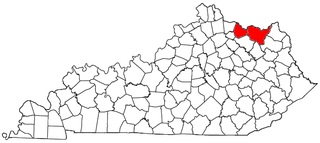
The Frankfort Micropolitan Statistical Area, as defined by the United States Census Bureau, is an area consisting of two counties in central Kentucky, anchored by the city of Frankfort. As of the 2000 census, the Micropolitan Statistical Area (μSA) had a population of 66,798.

The Richmond-Berea Micropolitan Statistical Area, as defined by the United States Census Bureau, is an area consisting of two counties in Kentucky, anchored by the cities of Richmond and Berea. As of the 2000 census, the μSA had a population of 87,454.
The Mount Sterling Micropolitan Statistical Area, as defined by the United States Census Bureau, is an area consisting of three counties in Kentucky, anchored by the city of Mount Sterling. As of the 2000 census, the μSA had a population of 40,195.

The Muscatine Micropolitan Statistical Area, as defined by the United States Census Bureau, is an area consisting solely of Muscatine County and anchored by the city of Muscatine. The Muscatine Micropolitan Statistical Area is also a part of the Quad Cities Iowa–Illinois Combined Statistical Area (CSA), which has a population of 474,226, making it the 90th-largest CSA in the nation.

The Glasgow Micropolitan Statistical Area, as defined by the United States Census Bureau, is an area consisting of two counties in Kentucky, anchored by the city of Glasgow. As of the 2000 census, the μSA had a population of 48,070.
The Danville Micropolitan Statistical Area, as defined by the United States Census Bureau, is an area consisting of Boyle and Lincoln counties in Kentucky, anchored by the city of Danville. As of the 2000 census, the μSA had a population of 51,058. A July 1, 2009 estimate placed the population at 54,435.
The Maysville Micropolitan Statistical Area (μSA), as defined by the United States Census Bureau, is coterminous with Mason County, Kentucky, whose county seat and largest city is Maysville. As of the 2010 census, the population of Mason County and the current µSA was 17,490, and 2014 Census Bureau estimates place the population at 17,166.

The Martinsville Micropolitan Statistical Area is a United States Micropolitan Statistical Area (USA) in Virginia, as defined by the Office of Management and Budget (OMB) as of June, 2003. As of the 2000 census, the μSA had a population of 73,346.
The Jasper micropolitan statistical area, as defined by the United States Census Bureau, is an area consisting of one county in southwestern Indiana, anchored by the city of Jasper. At the 2020 census, the Micropolitan area (μSA) had a population of 43,637 up from a population of 41,889 in the 2010 census. In previous statistical definition updates, the area also included Pike County which was removed in the 2023 updates.

The Dublin Micropolitan Statistical Area, as defined by the United States Census Bureau, is an area consisting of two counties in Georgia, anchored by the city of Dublin.

The Lafayette-West Lafayette, Indiana Metropolitan Statistical Area, as defined by the United States Census Bureau, is an area consisting of three counties in Indiana, anchored by the cities of Lafayette and West Lafayette. As of the July 1, 2021, the MSA had an estimated population of 224,709. Metro area population in 2021 is 237,130 and was 235,066 in 2020, a growth of 16% over 2010. In 2010, the Lafayette, Indiana, metro area population was 210,297.

