Tillamook County is one of the 36 counties in the U.S. state of Oregon. As of the 2020 census, the population was 27,390. The county seat is Tillamook. The county is named for the Tillamook or Killamook people, a Native American tribe who were living in the area in the early 19th century at the time of European American settlement. The county is located within Northwest Oregon.

Manzanita is a coastal city in Tillamook County, Oregon, United States. It is located on U.S. Route 101 about 25 miles (40 km) equidistant from Seaside to the north and Tillamook to the south. The population was 603 at the 2020 census.
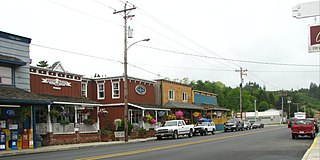
Nehalem is a city in Tillamook County, Oregon, United States. Incorporated in 1889, the city lies along the Nehalem River and Nehalem Bay near the Pacific Ocean. It is bisected by U.S. Route 101. The population was 355 at the 2020 census.

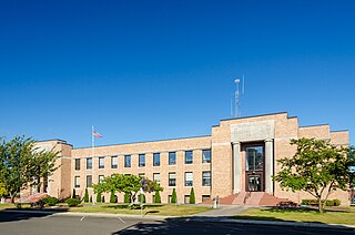
The city of Tillamook is the county seat of Tillamook County, Oregon, United States. The city is located on the southeast end of Tillamook Bay on the Pacific Ocean. The population was 5,231 at the 2020 census.

The Tillamook County Creamery Association (TCCA) is a farmer-owned dairy cooperative headquartered in Tillamook County, Oregon, United States. The association manufactures and sells dairy products under the "Tillamook" brand name. Its main facility is the Tillamook Creamery, located two miles north of the city of Tillamook on U.S. Route 101.

The Nehalem River is a river on the Pacific coast of northwest Oregon in the United States, approximately 119 miles (192 km) long. It drains part of the Northern Oregon Coast Range northwest of Portland, originating on the east side of the mountains and flowing in a loop around the north end of the range near the mouth of the Columbia River. Its watershed of 855 square miles (2,210 km2) includes an important timber-producing region of Oregon that was the site of the Tillamook Burn. In its upper reaches it flows through a long narrow valley of small mountain communities but is unpopulated along most of its lower reaches inland from the coast.

Barview is an unincorporated community in Tillamook County, Oregon, United States, named in 1884 by L. C. Smith for its exceptional view of the bar at the entrance to Tillamook Bay.
The Tillamook are a Native American tribe from coastal Oregon of the Salish linguistic group. The name "Tillamook" is a Chinook language term meaning "people of [the village] Nekelim ", sometimes it is given as a Coast Salish term, meaning "Land of Many Waters". The Tillamook tribe consists of several divisions and dialects, including :

Umapine (/uməpaɪn/) is a census-designated place and unincorporated community in Umatilla County, Oregon, United States, two miles from the Oregon-Washington border. The traditional boundary covers a wide area. It has a population of 315 people as of 2010. The community is part of the Pendleton–Hermiston Micropolitan Statistical Area. The current economy is supported by agriculture, including wheat and hay farms, apple orchards, and an increasing number of vineyards. The main establishments in the town are Tate's Umapine Market, The Umapine Creamery and the Waterhole Tavern.

Manhattan Beach State Recreation Site is a state park in the U.S. state of Oregon. Administered by the Oregon Parks and Recreation Department, the park is open to the public and is fee-free. Amenities at the park, which is 2 miles (3 km) north of Rockaway Beach along U.S. Route 101, include picnicking, fishing, and a Pacific Ocean beach.

Elsie is an unincorporated community in Clatsop County, Oregon, United States. It is located in the Northern Oregon Coast Range, west of the junction of Oregon Route 103 and U.S. Route 26 where the roads cross the Nehalem River.
Brighton is an unincorporated community in Tillamook County, Oregon, United States. It is about 3 kilometres (2 mi) southwest of Wheeler on U.S. Route 101 next to Nehalem Bay, across the bay from Nehalem Bay State Park.
Oretown is an unincorporated community in Tillamook County, Oregon, United States. It is along U.S. Route 101 about 4 miles (6 km) north of Neskowin and south of Nestucca Bay.
Lees Camp is an unincorporated community in Tillamook County, Oregon, United States. It is along Oregon Route 6 about 25 miles (40 km) northeast of Tillamook at the confluence of the Wilson River and North Fork Wilson River, surrounded by the Tillamook State Forest. It is near the summit of the Northern Oregon Coast Range.

Foss is an unincorporated community in Tillamook County, Oregon, United States. It is about 4 miles (6 km) east of Mohler and Oregon Route 53, near the Nehalem River. Foss is the site of an important river flood gauge.

Sue H. Elmore was a steamboat built for service on the coast of Oregon and southwest Washington. From 1900 to 1917, the vessel's principal route ran from Portland, Oregon down the Columbia River to Astoria, and then west across the Columbia Bar, then south along the Oregon coast to Tillamook Bay. Once at Tillamook Bay, Sue H. Elmore was one of the few vessels that could reach Tillamook City at the extreme southern edge of the mostly very shallow bay. After this Sue H. Elmore was sold, being operated briefly in Puget Sound under the name Bergen, and then for many years, out of San Diego, California as a tugboat under the name Cuyamaca. During World War II Cuyamaca was acquired by the U.S. Army which operated the vessel as ST-361. Afterwards the army sold ST-361 and the vessel returned to civilian ownership, again under the name Cuyamaca. In 1948 Cuyamaca sank in a harbor in Venezuela, but was raised and by the early 1950s, was owned by one A. W. Smith, of Pensacola, Florida. This vessel's former landing place in Tillamook, Oregon is now a municipal park named after the ship.

Juneta was a passenger ferry that operated on the Nehalem River on the north coast of Oregon from 1910 to the mid-1920s. Thereafter this vessel was transferred to the Columbia River where it was operated out of Astoria as a cannery tender until the 1960s. Juneta was then converted to a tugboat, and operated commercially on the Columbia and Willamette rivers until 1976. Juneta is still in existence and afloat as a private yacht in the vicinity of Portland, Oregon.
Hobsonville is an unincorporated community in Tillamook County, Oregon, United States. Although it is considered a ghost town, it is still classified as a populated place by the United States Geological Survey (USGS). Hobsonville is on the east shore of Tillamook Bay, about 2 miles south of Garibaldi via U.S. Route 101 or about a mile from Garibaldi across Miami Cove.
Watseco is an unincorporated community in Tillamook County, Oregon, United States. It is near two other unincorporated communities in Tillamook County, Barview and Twin Rocks. The three communities are all along a 3-mile (5 km) stretch of U.S. Route 101 between the cities of Rockaway Beach and Garibaldi.
Barnesdale is an unincorporated community and census-designated place (CDP) in Tillamook County, Oregon, United States. It was first listed as a CDP prior to the 2020 census.


