Tillamook County is one of the 36 counties in the U.S. state of Oregon. As of the 2020 census, the population was 27,390. The county seat is Tillamook. The county is named for the Tillamook or Killamook people, a Native American tribe who were living in the area in the early 19th century at the time of European American settlement. The county is located within Northwest Oregon.
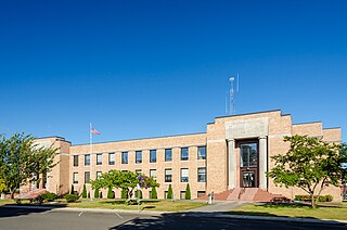
Garibaldi is a city in Tillamook County, in the U.S. state of Oregon. The population was 830 at the 2020 census.
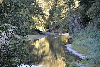
The Miami River is a stream, approximately 13 miles (21 km) long, on the coast of northwest Oregon in the United States. It drains a mountainous timbered region of the Northern Oregon Coast Range west of Portland, into Pacific Ocean.

The Salmonberry River is a tributary of the Nehalem River, about 20 miles (32 km) long, in northwest Oregon in the United States. It drains a remote unpopulated area of the Northern Oregon Coast Range in the Tillamook State Forest about 65 miles (105 km) west-northwest of Portland. The river runs through part of the region devastated between 1933 and 1951 by a series of wildfires known as the Tillamook Burn.

Barview is an unincorporated community in Tillamook County, Oregon, United States, named in 1884 by L. C. Smith for its exceptional view of the bar at the entrance to Tillamook Bay.
The Tillamook are a Native American tribe from coastal Oregon of the Salish linguistic group. The name "Tillamook" is a Chinook language term meaning "people of [the village] Nekelim ", sometimes it is given as a Coast Salish term, meaning "Land of Many Waters". The Tillamook tribe consists of several divisions and dialects, including :

Manhattan Beach State Recreation Site is a state park in the U.S. state of Oregon. Administered by the Oregon Parks and Recreation Department, the park is open to the public and is fee-free. Amenities at the park, which is 2 miles (3 km) north of Rockaway Beach along U.S. Route 101, include picnicking, fishing, and a Pacific Ocean beach.

John West (1809–1888) was a Scottish inventor and businessman who emigrated to Canada, California and later Oregon where he operated a cannery and exported tuna to Great Britain.
Brighton is an unincorporated community in Tillamook County, Oregon, United States. It is about 3 kilometres (2 mi) southwest of Wheeler on U.S. Route 101 next to Nehalem Bay, across the bay from Nehalem Bay State Park.

Warrendale is an unincorporated community in Multnomah County, Oregon, United States. It is located about a mile east of Dodson and about 3 miles (4.8 km) west of Bonneville in the Columbia River Gorge on Interstate 84/U.S. Route 30. It is across the Columbia River from Beacon Rock. The community was the site of an important salmon cannery founded in the 1870s.
Oretown is an unincorporated community in Tillamook County, Oregon, United States. It is along U.S. Route 101 about 4 miles (6 km) north of Neskowin and south of Nestucca Bay.
Clifton is an unincorporated community in Clatsop County, Oregon, United States. It is located north of U.S. Route 30, about nine miles northwest of Westport on the south bank of the Columbia River. It is on Clifton Channel across from Tenasillahe Island.

Foss is an unincorporated community in Tillamook County, Oregon, United States. It is about 4 miles (6 km) east of Mohler and Oregon Route 53, near the Nehalem River. Foss is the site of an important river flood gauge.

Sue H. Elmore was a steamboat built for service on the coast of Oregon and southwest Washington. From 1900 to 1917, the vessel's principal route ran from Portland, Oregon down the Columbia River to Astoria, and then west across the Columbia Bar, then south along the Oregon coast to Tillamook Bay. Once at Tillamook Bay, Sue H. Elmore was one of the few vessels that could reach Tillamook City at the extreme southern edge of the mostly very shallow bay. After this Sue H. Elmore was sold, being operated briefly in Puget Sound under the name Bergen, and then for many years, out of San Diego, California as a tugboat under the name Cuyamaca. During World War II Cuyamaca was acquired by the U.S. Army which operated the vessel as ST-361. Afterwards the army sold ST-361 and the vessel returned to civilian ownership, again under the name Cuyamaca. In 1948 Cuyamaca sank in a harbor in Venezuela, but was raised and by the early 1950s, was owned by one A. W. Smith, of Pensacola, Florida. This vessel's former landing place in Tillamook, Oregon is now a municipal park named after the ship.

Juneta was a passenger ferry that operated on the Nehalem River on the north coast of Oregon from 1910 to the mid-1920s. Thereafter this vessel was transferred to the Columbia River where it was operated out of Astoria as a cannery tender until the 1960s. Juneta was then converted to a tugboat, and operated commercially on the Columbia and Willamette rivers until 1976. Juneta is still in existence and afloat as a private yacht in the vicinity of Portland, Oregon.

C.H. Wheeler was a schooner-rigged unpowered lumber barge that operated during the year 1901, making only a few voyages before it was wrecked near Yaquina Bay with the loss of one life. C.H. Wheeler was the largest vessel up to that time to reach Tillamook City and the first vessel to transport a load of lumber from Tillamook to San Francisco. The circumstances of the loss of the C.H. Wheeler were controversial and resulted in the arrest of the captain of the tug that had been towing the barge before it was wrecked.
W.H. Harrison was a steam schooner that operated from 1890 to 1905 on the coast of Oregon, the lower Columbia River, and southwest Washington state. At that time the salmon cannery industry was one of the major businesses of the coast. W.H. Harrison, while also carrying passengers and transporting general freight and lumber, was one of a number of steamers supplying materials to canneries along the coast, and transporting cases of canned salmon from the canneries.

George R. Vosburg was a steam tug that operated from 1900 to 1912 on the Columbia River and the north coast of Oregon south from Astoria to the Nehalem River and Tillamook City. Generally called the Vosburg in practice, and referred to as Geo. R. Vosburg in official records, this vessel performed many tasks, from carrying cargo and passengers, and towing barges of rock for jetty construction. After 1925, this vessel was renamed George M. Brown, and was converted to diesel power. Under the name George M. Brown, this vessel remained in service until 1968 or later.
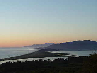
Nehalem Bank is a bar, off the coast of Oregon, United States. It also has both rocky reefs and mud habitat, and is just northwest of Garibaldi Reef.
Barnesdale is an unincorporated community and census-designated place (CDP) in Tillamook County, Oregon, United States. It was first listed as a CDP prior to the 2020 census.


