
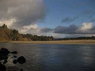
The Smith River is a 90-mile (140 km) tributary of the Umpqua River in the U.S. state of Oregon. It drains 352 square miles (910 km2) of the Central Oregon Coast Range between the watershed of the Umpqua to the south and the Siuslaw River to the north.
The Salmon River flows from the Central Oregon Coast Range to the Pacific Ocean coast of northwest Oregon in the United States. About 24 miles (39 km) long, it begins and ends in Lincoln County but also flows briefly through western Polk and southern Tillamook counties. Much of its course lies within the Siuslaw National Forest.
The Miami River is a stream, approximately 13 miles (21 km) long, on the coast of northwest Oregon in the United States. It drains a mountainous timbered region of the Northern Oregon Coast Range west of Portland, into Pacific Ocean.

Twin Rocks is an unincorporated community in Tillamook County, Oregon, United States, on the Oregon Coast. Twin Rocks, founded as a summer resort community, was named for two offshore rocks, 100 feet (30 m) high, in the Pacific Ocean. Twin Rocks post office was established in 1914, with William E. Dunsmoor as the first postmaster. The post office closed in 1954.

Barview is an unincorporated community in Tillamook County, Oregon, United States, named in 1884 by L. C. Smith for its exceptional view of the bar at the entrance to Tillamook Bay.

Bull Run is an unincorporated community in Clackamas County, Oregon, United States. It is located about 5 miles northeast of Sandy, near the Bull Run River and the powerhouse of the defunct Mount Hood Railway and Power Company.

Gales Creek is an unincorporated community in Washington County, Oregon, United States on Oregon Route 8 northwest of Forest Grove in the foothills of the Oregon Coast Range.

Wilkesboro is an unincorporated community in Washington County, Oregon, United States. It is located on Oregon Route 6, one mile east of Banks.

Dolph is an unincorporated community in Tillamook County, Oregon, United States, near the Yamhill County line. It lies at the junction of Oregon Route 22 and Oregon Route 130 between Grande Ronde and Hebo, on the Little Nestucca River. It is within the Siuslaw National Forest in the Northern Oregon Coast Range.
Galena is an unincorporated community in Grant County, Oregon, United States, about 20 miles (32 km) from Austin Junction in the Blue Mountains. It is on the Middle Fork John Day River in the Malheur national forest. The former gold mining camp is considered a ghost town.

Susanville is an unincorporated community in Grant County, Oregon, United States, in the Blue Mountains about two miles up Elk Creek from Galena. The place was started as a gold mining camp in 1862 or 1864 and is now considered a ghost town.

Lancaster is an unincorporated community in Lane County, Oregon, United States. It is located about two miles south of Harrisburg and two miles north of Junction City, on Oregon Route 99E near the Willamette River.
Mohler is an unincorporated community in Tillamook County, Oregon, United States. It is east of U.S. Route 101 on Oregon Route 53 along the Nehalem River.
Pleasant Valley is an unincorporated community in Tillamook County, Oregon, United States. It is located about seven miles south of Tillamook, on U.S. Route 101.

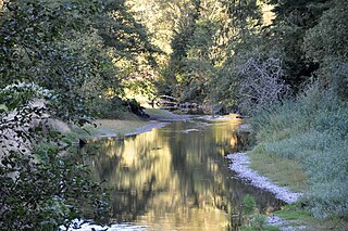
Whychus Creek is a tributary of the Deschutes River in Deschutes and Jefferson counties in the U.S. state of Oregon. Formerly named Squaw Creek, considered derogatory in the 21st century, it was renamed in 2006. Explorer John C. Frémont camped along the stream in 1843 but did not identify it by name. Robert S. Williamson, a surveyor who camped there in 1855, said its Indian name was Why-chus.
Lees Camp is an unincorporated community in Tillamook County, Oregon, United States. It is along Oregon Route 6 about 25 miles (40 km) northeast of Tillamook at the confluence of the Wilson River and North Fork Wilson River, surrounded by the Tillamook State Forest. It is near the summit of the Northern Oregon Coast Range.

Foss is an unincorporated community in Tillamook County, Oregon, United States. It is about 4 miles (6 km) east of Mohler and Oregon Route 53, near the Nehalem River. Foss is the site of an important river flood gauge.
Hobsonville is an unincorporated community in Tillamook County, Oregon, United States. Although it is considered a ghost town, it is still classified as a populated place by the United States Geological Survey (USGS). Hobsonville is on the east shore of Tillamook Bay, about 2 miles south of Garibaldi via U.S. Route 101 or about a mile from Garibaldi across Miami Cove.
Hemlock is an unincorporated community in Tillamook County, in the U.S. state of Oregon. It lies along U.S. Route 101 about 3 miles (5 km) north of Beaver. Beaver Creek, a tributary of the Nestucca River, flows through Hemlock.
Watseco is an unincorporated community in Tillamook County, Oregon, United States. It is near two other unincorporated communities in Tillamook County, Barview and Twin Rocks. The three communities are all along a 3-mile (5 km) stretch of U.S. Route 101 between the cities of Rockaway Beach and Garibaldi.

