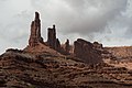
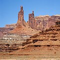
Monster Tower

Last updated
Monster Tower
Monster Tower.jpg
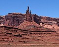
Monster Tower upper right, south aspect
Highest point
Elevation 5,835 ft (1,779 m) [1]
Prominence 395 ft (120 m) [1]
Parent peak Aztec Butte (6,312 ft) [1]
Isolation 3.91 mi (6.29 km) [2]
Coordinates 38°23′22″N109°50′15″W / 38.389572°N 109.837446°W / 38.389572; -109.837446 Coordinates: 38°23′22″N109°50′15″W / 38.389572°N 109.837446°W / 38.389572; -109.837446 [1]
Geography
USA Utah relief location map.svg
Red triangle with thick white border.svg
Monster Tower
Location of Monster Tower in Utah
Usa edcp relief location map.png
Red triangle with thick white border.svg
Monster Tower
Monster Tower (the United States)
Location Canyonlands National Park
San Juan County, Utah, U.S.
Parent range Colorado Plateau
Topo map USGS Musselman Arch
Geology
Age of rock Late Triassic
Type of rock Wingate Sandstone
Climbing
First ascent December 26, 1963
Easiest route class 5.11 Climbing [2]

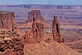
Monster Tower is a 600-foot (180-meter) tall sandstone tower located in the Island in the Sky District of Canyonlands National Park, in San Juan County, Utah, United States.

Contents

Description

The tower is situated 300 feet southeast of Washer Woman, which is a towering arch nearly as high. Washer Woman is so named because the feature gives the appearance of a woman bent over a washtub. [3] Monster and Washer Woman are an eroded fin composed of Wingate Sandstone, which is the remains of wind-borne sand dunes deposited approximately 200 million years ago in the Late Triassic. The nearest higher neighbor is Aztec Butte, 2 mi (3.2 km) to the west-northwest, Airport Tower is set 1.6 mi (2.6 km) to the east, and Mesa Arch is situated 1.5 mi (2.4 km) to the west. [1] A short hike to Mesa Arch provides the easiest view of Monster Tower. Access to the tower is via the four-wheel drive White Rim Road, which is the other way to see Monster. The top of this geological formation rises 1,400 feet above the road in approximately one mile. Precipitation runoff from Monster Tower drains southeast into the nearby Colorado River via Buck Canyon.

Climbing

The first ascent of Monster Tower was made in December 1963 by Layton Kor, Larry Dalke, and Cub Schaefer via the South Ridge (class 5.11). [4] The best route on Monster is the class 5.11a North Ridge, which was first climbed in 1981 by Ken Trout and Kirk Miller. Another alpine route, Monster of Rock (5.11) on the south face, was first climbed in 1982 by Edward Webster and Chester Dreiman. [5] Los Banditos is an aid climb. [6]

Climate

Spring and fall are the most favorable seasons to visit Monster Tower. According to the Köppen climate classification system, it is located in a Cold semi-arid climate zone, which is defined by the coldest month having an average mean temperature below −0 °C (32 °F) and at least 50% of the total annual precipitation being received during the spring and summer. This desert climate receives less than 10 inches (250 millimeters) of annual rainfall, and snowfall is generally light during the winter.

See also

Related Research Articles

Canyonlands National Park National park in Utah, United States

Canyonlands National Park is an American national park located in southeastern Utah near the town of Moab. The park preserves a colorful landscape eroded into numerous canyons, mesas, and buttes by the Colorado River, the Green River, and their respective tributaries. Legislation creating the park was signed into law by President Lyndon Johnson on September 12, 1964.

Colorado Plateau Plateau in the Four Corners region of the Southwest United States

The Colorado Plateau, also known as the Colorado Plateau Province, is a physiographic and desert region of the Intermontane Plateaus, roughly centered on the Four Corners region of the southwestern United States. This province covers an area of 336,700 km2 (130,000 mi2) within western Colorado, northwestern New Mexico, southern and eastern Utah, northern Arizona, and a tiny fraction in the extreme southeast of Nevada. About 90% of the area is drained by the Colorado River and its main tributaries: the Green, San Juan, and Little Colorado. Most of the remainder of the plateau is drained by the Rio Grande and its tributaries.

Navajo Sandstone Geological formation in the southwestern U.S.

The Navajo Sandstone is a geological formation in the Glen Canyon Group that is spread across the U.S. states of southern Nevada, northern Arizona, northwest Colorado, and Utah as part of the Colorado Plateau province of the United States.

Arches National Park National park in Utah, United States

Arches National Park is a national park in eastern Utah, United States. The park is adjacent to the Colorado River, 4 miles (6 km) north of Moab, Utah. More than 2,000 natural sandstone arches are located in the park, including the well-known Delicate Arch, as well as a variety of unique geological resources and formations. The park contains the highest density of natural arches in the world.

Mesa Arch

Mesa Arch is a pothole arch on the eastern edge of the Island in the Sky mesa in Canyonlands National Park in northern San Juan County, Utah, United States. Mesa Arch is a spectacular natural stone arch perched at the edge of a cliff with vast views of canyons, Monster Tower, Washer Woman Arch, Airport Tower, and the La Sal Mountains in the distance. Access is via a relatively easy hiking trail, just a half-mile long from the park road.

Druid Arch

Druid Arch is an iconic 150-foot tall Cedar Mesa Sandstone arch located within the Needles District of Canyonlands National Park, in San Juan County, Utah. It is situated at the head of Elephant Canyon, and precipitation runoff from Druid Arch drains north into the nearby Colorado River via Elephant Canyon. Druid Arch is one of the most popular hiking destinations in the Needles district. A 5.4 mile hike to Druid Arch starts at the Elephant Hill Trailhead, and the final quarter-mile is steep with some scrambling and one ladder. The name comes from its resemblance to the Stonehenge monument in England, which is believed to be a Druid temple. This feature's name was officially adopted in 1963 by the U.S. Board on Geographic Names.

Angel Arch

Angel Arch is the largest natural arch located within Canyonlands National Park, in San Juan County, Utah. Some consider it the most beautiful and spectacular arch in the park, if not the entire canyon country. It is situated in a side canyon of Salt Creek Canyon, in the Needles District of the park. Precipitation runoff from Angel Arch drains north into the nearby Colorado River via Salt Creek. A 29-mile round-trip hike to Angel Arch leads to a viewpoint, and an additional 0.75-mile trail scrambles up into the arch opening. The arch's descriptive name comes from its resemblance to an angel with wings folded, and standing with its back to the arch opening. Before this feature's name was officially adopted in 1963 by the U.S. Board on Geographic Names, it was called Pegasus Arch. The first ascent was made in June 1993, by John Markel and Kevin Chase.

Candlestick Tower Rock formation in Utah, United States

Candlestick Tower is a 450-foot-tall (140 m) sandstone butte located in the Island in the Sky District of Canyonlands National Park, in San Juan County, Utah. Its descriptive name comes from its resemblance to a candlestick. Candlestick Tower is composed of Wingate Sandstone, which is the remains of wind-borne sand dunes deposited approximately 200 million years ago in the Late Triassic.

Washer Woman

Washer Woman is a 500-foot (150-meter) tall sandstone arch and tower located in the Island in the Sky District of Canyonlands National Park, in San Juan County, Utah. It is situated 300 feet northwest of the slightly higher Monster Tower. Washer Woman is so named because the feature gives the appearance of a washerwoman bent over a washtub. This geographical feature's name was officially adopted in 1986 by the U.S. Board on Geographic Names after previously having similar names such as Washer-Woman Arch and The Washer Woman. Washer Woman and Monster Tower are an eroded fin composed of Wingate Sandstone, which is the remains of wind-borne sand dunes deposited approximately 200 million years ago in the Late Triassic. Airport Tower is set 1.6 mi (2.6 km) to the east, and Mesa Arch is situated 1.5 mi (2.4 km) to the west. A short hike to Mesa Arch provides the easiest view of Washer Woman. Access to this formation is via the four-wheel drive White Rim Road, which is the other option to see it. The top of this geological formation rises 1,300 feet above the road in approximately one mile. Precipitation runoff from Washer Woman drains southeast into the nearby Colorado River via Buck Canyon.

Airport Tower (Canyonlands)

Airport Tower is a 700-foot (210-meter) tall sandstone butte located in the Island in the Sky District of Canyonlands National Park, in San Juan County, Utah. It is situated 1.64 mile east of Washer Woman, which is a towering arch similar in height. Each are composed of Wingate Sandstone, which is the remains of wind-borne sand dunes deposited approximately 200 million years ago in the Late Triassic. The nearest higher neighbor is Monster Tower, 1.6 mi (2.6 km) to the west, Tiki Tower is one-half mile northwest, and Mesa Arch is situated 3.2 mi (5.1 km) to the west. A short hike to Mesa Arch provides the easiest view of Airport Tower. Access to this tower is via the four-wheel drive White Rim Road, which is another option to see Airport Tower. The top of this geological formation rises 1,400 feet above the road in less than one mile. Precipitation runoff from Airport Tower drains southeast into the nearby Colorado River via Buck and Lathrop Canyons. This geographical feature's name was officially adopted in 1986 by the U.S. Board on Geographic Names. It was so named because the rock formation resembles the appearance of an airport control tower.

Zeus and Moses Rock formations in Utah, United States

Zeus and Moses are a pair of 500-foot-tall (150 m) sandstone formations located in the Island in the Sky District of Canyonlands National Park, in San Juan County, Utah, United States. These rock towers' names refer to Zeus, a god in Greek mythology, and Moses, an important prophet in several religious traditions. Zeus and Moses are composed of Wingate Sandstone, which is the remains of wind-borne sand dunes deposited approximately 200 million years ago in the Late Triassic. This formation is situated in Taylor Canyon, 3 mi (4.8 km) north-northeast of Upheaval Dome. Access to the towers is via the four-wheel-drive White Rim Road, and a spur road into Taylor Canyon. The top of this geological formation rises 900 feet above the canyon floor at road's end, approximately one-half mile away. Precipitation runoff from Zeus and Moses drains into the nearby Green River via Taylor Canyon.

Aztec Butte Rock formation in Utah, United States

Aztec Butte is a sandstone summit, elevation 6,312 feet, located in the Island in the Sky District of Canyonlands National Park, in San Juan County, Utah. Aztec Butte is composed of white cross-bedded Navajo Sandstone, which is the remains of wind-borne sand dunes deposited approximately 170 million years ago during the Jurassic Period. It resembles the Pyramid of the Sun in Mexico, which was built by the Aztecs.

Buttes of the Cross

Buttes of the Cross is two sandstone summits located in the northern reach of Glen Canyon National Recreation Area, in Wayne County of Utah, United States. The larger and higher south butte reaches an elevation of 5,642 feet, whereas the north butte rises to 5,569 feet, with approximately 0.6 mile separation between them. When viewed from the north-northeast near Labyrinth Canyon, they align to form the shape of a cross, creating the appearance of a single butte. The name "Butte of the Cross" was first applied by John Wesley Powell during the Powell Geographic Expedition of 1869. A few miles further down the Green River, Powell finds that this geographical feature is two buttes when viewed from the east, so it was renamed Buttes of the Cross. Buttes of the Cross towers over 1,400 feet above its surrounding terrain. It is situated 6.8 miles west of Candlestick Tower, and one-half mile outside the boundary of Canyonlands National Park.

Elaterite Butte

Elaterite Butte is a 6,552-foot (1,997-meter) elevation summit located in The Maze District of Canyonlands National Park, in Wayne County, Utah. Elaterite Butte is situated 6 mi (9.7 km) southwest of Ekker Butte, and the Maze Overlook is situated 2.5 mi (4.0 km) to the northeast. Elaterite Butte is composed of hard, fine-grained Wingate Sandstone, which is the remains of wind-borne sand dunes deposited approximately 200 million years ago in the Late Triassic. This Wingate sandstone overlays a 432-foot thick layer of the softer Chinle Formation. The top of this geological formation rises over 1,400 feet above Elaterite Basin. The butte and basin are named for elaterite, which is a dark brown, tar-like, elastic mineral resin that seeps from parts of the nearby White Rim Sandstone. Access to the remote butte is via a four-wheel drive road in Elaterite Basin. Precipitation runoff from Elaterite Butte drains into the nearby Green River, which in turn is within the Colorado River drainage basin.

Chip and Dale Towers

Chip and Dale Towers are two 300-foot (91-meter) tall sandstone towers located in the Island in the Sky District of Canyonlands National Park, in San Juan County, Utah. Dale Tower rises to an elevation of 5,620 feet, whereas the lower Chip Tower is 5,420-feet. Airport Tower is set 2.5 mi (4.0 km) to the southwest, and Dead Horse Point State Park overlook is situated 4.5 mi (7.2 km) to the north-northeast. Chip and Dale Towers are an eroded fin composed of hard, fine-grained Wingate Sandstone, which is the remains of wind-borne sand dunes deposited approximately 200 million years ago in the Late Triassic. This Wingate Sandstone overlays a softer layer of the Chinle Formation. Access to the towers is via the four-wheel drive White Rim Road, and a scramble to reach the base. The top of the towers rise over 1,000 feet above the road in approximately one-half mile. Precipitation runoff from Chip and Dale Towers drains east to the nearby Colorado River.

Sixshooter Peaks

The Sixshooter Peaks are two iconic sandstone summits located in Bears Ears National Monument, in San Juan County of Utah, United States. The larger and higher North Sixshooter Peak rises to an elevation of 6,379 feet, whereas South Sixshooter Peak rises to 6,154 feet, with approximately 1.5 mile separation between the two. These buttes tower nearly 1,400 feet above the surrounding terrain, and are historic landmarks visible from State Route 211 between Newspaper Rock and the Needles District of Canyonlands National Park. They are situated 1.5 mile outside the boundary of the park, and four miles northwest of Bridger Jack Butte. Variant names for the peaks include "North Six-Shooter Peak", "South Six-shooter Peak", "Six Shooter Peaks", and "Six-shooter Peak". They are so named because of their resemblance to a pair of revolvers pointing skyward.

Bridger Jack Butte

The Bridger Jack Butte is a sandstone summit located in Bears Ears National Monument, in San Juan County of Utah, United States. This butte, which is set at the northern tip of namesake Bridger Jack Mesa, and above the confluence of Indian and Lavender Creeks, rises to an elevation of 5,890 feet, and towers over 700 feet above the surrounding terrain and floor of Lavender Canyon to its west. This landmark is situated four miles southeast of Sixshooter Peaks, and is visible from State Route 211 between Newspaper Rock and the Needles District of Canyonlands National Park. "Bridger Jack" was a Paiute medicine man.

Tiki Tower

Tiki Tower is a thin 300-foot (91-meter) tall sandstone pinnacle located in the Airport Tower/Monster Tower/Washer Woman area of the Island in the Sky District of Canyonlands National Park, in San Juan County, Utah. It is situated one-half mile northwest of Airport Tower, and is composed of Wingate Sandstone, which is the remains of wind-borne sand dunes deposited approximately 200 million years ago in the Late Triassic. Access to this tower is via the four-wheel-drive White Rim Road. The top of this spire rises 1,100 feet above the road in a little more than one mile. Precipitation runoff from Tiki Tower drains southeast into the nearby Colorado River via Buck and Lathrop Canyons. The first ascent of Tiki Tower was made in November 1991 by Jeff Widen and Mitch Allen, via Brave Little Toaster, with Fred Lifton and Paul Frank working the first pitch.

Kissing Couple

Kissing Couple is a 5,815-foot-elevation (1,772-meter) sandstone pillar located in Colorado National Monument, in Mesa County of western Colorado, United States. This iconic 400-foot-high tower is situated on the west side of Monument Canyon, 1.5 mile southeast of the monument's visitor center, and 9 miles (14 km) west of the community of Grand Junction. It is also a half-mile south-southeast of another popular climbing destination, Independence Monument, and both can be seen from viewpoints along Rim Rock Drive. It is so named because it resembles an embracing couple. This geographical feature's name was officially adopted in 1982 by the United States Board on Geographic Names. Older USGS maps have the feature's name misplaced by about one-half mile to the southeast. The first ascent of the summit was made May 4, 1960, by Layton Kor, Harvey Carter, and John Auld via the five pitch, class 5.11a route named Long Dong Wall. The first free ascent was made in 1977 by Andy Petefish, Tom Stubbs, and Jim Pearson. Some climbers alternatively refer to Kissing Couple as "Bell Tower."

Aires Butte

Aires Butte is a 6,492-foot (1,979 m) summit located in Zion National Park, in Washington County of southwest Utah, United States. It is composed of white Navajo Sandstone, and rises 1,100-feet above the Zion – Mount Carmel Highway. Aires Butte is situated 0.9 mi (1.4 km) east-northeast of Ant Hill, 1.5 mi (2.4 km) north of Nippletop, and 1.9 mi (3.1 km) northwest of Checkerboard Mesa. Precipitation runoff from this mountain drains into tributaries of the Virgin River.

References

  1. 1 2 3 4 5 "Monster Tower, Utah". Peakbagger.com. Retrieved 2020-08-30.
  2. 1 2 ""Monster Tower" - 5,880' UT". listsofjohn.com. Retrieved 2020-08-30.
  3. "Washer Woman". Geographic Names Information System . United States Geological Survey . Retrieved 2020-08-30.
  4. Stewart M. Green, Rock Climbing Utah, Falcon Guides, Morris Book Publishing, 2012, page 70.
  5. The American Alpine Journal, The Mountaineers Books, 1983, page 166.
  6. Monster Tower thecrag.com