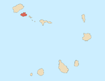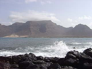
Monte Verde is a mountain in the eastern part of the island of São Vicente, Cape Verde. At 744 m elevation, it is the island's highest point. The mountain is located 6 km (4 mi) east of the city centre of Mindelo.

Tope de Coroa is a mountain on the island of Santo Antão's, Cape Verde. At 1,979 m elevation, it is the highest point of the island. It is in the western part of the island, 25 km west of the island capital Porto Novo. The mountain is entirely of volcanic origin. The area is the source of several streams including Ribeira de Monte Trigo which flows westward to Monte Trigo.

Monte Gordo is a mountain on the island of São Nicolau, Cape Verde. At 1,312 m elevation, it is the island's highest point. It is situated in the western part of the island, 6 km west of the island capital Ribeira Brava. The mountain is of volcanic origin, less than 1 million years old. The boundary of the municipalities Tarrafal de São Nicolau and Ribeira Brava runs over the mountain. It is part of the Monte Gordo Natural Park.

Monte Estância is a mountain in the southeastern part of the island Boa Vista in Cape Verde. At 387 m elevation, it is the island's highest point. It is located 4 km from the Atlantic coast and 23 km southeast of the island capital Sal Rei. It is part of a protected natural space under the statute of natural monument, which covers 739 ha.

Monte Penoso is a mountain on the island of Maio, Cape Verde. At 436 m elevation, it is the island highest point. It is situated in the eastern part of the island, 3 km southwest of Pedro Vaz and 13 km northeast of the island capital Porto Inglês. The mountain is of volcanic origin. It is part of the protected landscape Monte Penoso and Monte Branco, which covers 11.17 km2 (4.31 sq mi).
Monte Bissau is a mountain in the central part of the island of São Nicolau in Cape Verde. It is situated 3 km southwest of Belém and 6 km east of the island capital Ribeira Brava. Its elevation is 615 m.

Cova Joana is a village in the central part of the island of Brava, Cape Verde. It is situated in a mountain valley, 0.5 km north of Nossa Senhora do Monte and 2 km southwest of the island capital Nova Sintra. In 2010 its population was 183. Its elevation is 645 meters.
Monte São João is a low mountain in the central part of the island of São Vicente, Cape Verde. Its elevation is 154 m. It is situated 3 km southwest of the city centre of Mindelo.
Monte Montona is a low mountain in the western part of the island of São Vicente, Cape Verde. Its elevation is 242 m. It is situated 4 km northeast of São Pedro and 6 km southwest of the island capital Mindelo.

Monte Batalha is a mountain in the island of Maio in Cape Verde. Its elevation is 294 m. It is situated 4 km southeast of Calheta and 8 km northeast of the island capital Porto Inglês.

Monte Grande is a mountain in the northern part of the island of Sal in Cape Verde. It is situated 8 km northeast of the island capital Espargos. At 406 m elevation, it is the highest point of the island. It is a protected landscape because of its geological value; the protected area covers 1,309 ha. There are pillow lava formations on the coast.

Buracona is a small bay in the northwest of the island of Sal, Cape Verde. The bay is approximately 5 km north of the village Palmeira. The bay is part of the 5.45 km2 (2.10 sq mi) protected landscape of Buracona-Ragona, which covers the coast between Palmeira and Ponta Preta, and the mountain Monte Leste.
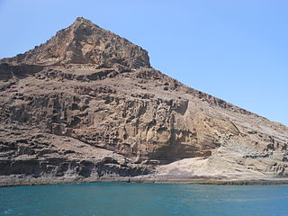
Rabo de Junco is a hill on the west coast of the island of Sal in Cape Verde. It is situated at the northern end of the Baía da Murdeira, 8 km southwest of the island capital Espargos. Its steep eroded south face towards the bay is an important nesting area for birds. Rabo de Junco and the surrounding area are protected as a nature reserve. It was mentioned as Rabadyunk in the 1747 map by Jacques-Nicolas Bellin. To its west lies the uninhabited islet Ilhéu Rabo de Junco.

Monte Trigo is the westernmost settlement on the island of Santo Antão, Cape Verde. It is situated on the coast, at the foot of the Tope de Coroa, the highest mountain of the island. It is 28 km west of the island capital Porto Novo. In 2010 its population was 274. About 5 km to the northwest is Ponta do Chão de Mangrade, the westernmost point of all Africa.

Ribeira de Calhau is a settlement in the eastern part of the island of Sao Vicente, Cape Verde. It takes its name from the river Ribeira do Calhau, and comprises the villages of Madeiral, Ribeira de Calhau and Calhau. Madeiral and Ribeira de Calhau are located in the river valley, Calhau is on the east coast. In 2010 its population was 1,177. The valley is surrounded by the mountains Viana, Madeiral, Pico do Vento and Monte Verde.

Monte Graciosa is a mountain in the northern part of the island of Santiago in Cape Verde. It lies 2.5 km north of the town of Tarrafal, overlooking the Baía de Tarrafal. Its elevation is 643 m. Towards the west it ends in the headland of Ponta Preta. It is part of a larger proposed natural park. The mountain is of volcanic origin, composed of phonolite and rich in feldspar and olivine.
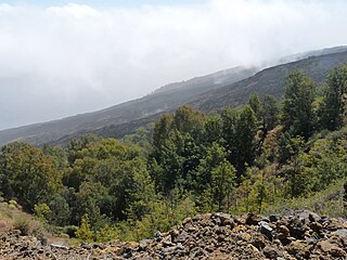
Monte Velha is a peak in the northeastern part of the island of Fogo in Cape Verde. Its elevation is 1,482 m. It is a subpeak of the Pico do Fogo volcano, located at the northeastern end of the crater rim. It lies within the municipality of Mosteiros, 4 km southwest of the city centre. Its forest is a protected area, part of the larger Fogo Natural Park.
Monte das Vacas is a mountain located in the southeastern part of the island of Santiago, Cape Verde. It is 2 km south of Ribeirão Chiqueiro and 8 km of the city centre of the capital Praia. Its elevation is 437 meters. It is of volcanic origin and was formed between 1.1 and 0.7 million years ago.
Longueira is a village in the southcentral part of the island of Santiago, Cape Verde. In 2010 its population was 326. Longueira is located 4 km southwest of João Teves and 1.5 km west of São Jorge. Monte Tchota, the highest point of the mountains of Rui Vaz, lies to the south.
Monte Tchota is a mountain located in the central part of Santiago Island in Cape Verde. Its elevation is 1,041 m. It is part of the Serra do Pico de Antónia Natural Park, and lies 1.5 km southeast of Pico de Antónia, the highest point of the island. The village Rui Vaz lies 3 km to the east.