Monte Barone

Last updated
Monte Barone
Denti di gavala monte barone da pizzo tracciora.jpg
View from Valsesia (foreground: Denti di Gavala)
Highest point
Elevation 2,044 m (6,706 ft) [1]
Prominence 622 m (2,041 ft) [1] [2]
Isolation 10.32 km (6.41 mi)  OOjs UI icon edit-ltr-progressive.svg
Listing Alpine mountains 2000-2499 m
Coordinates 45°44′15″N08°09′12″E / 45.73750°N 8.15333°E / 45.73750; 8.15333 Coordinates: 45°44′15″N08°09′12″E / 45.73750°N 8.15333°E / 45.73750; 8.15333
Geography
Alps location map.png
Red triangle with thick white border.svg
Monte Barone
Location in the Alps
Italy relief location map.jpg
Red triangle with thick white border.svg
Monte Barone
Monte Barone (Italy)
Location Province of Biella, Italy
Parent range Alpi Biellesi
Climbing
Easiest route from Piane di Coggiola

Monte Barone is a mountain of the Alpi Biellesi, a sub-range of the Pennine Alps. Due to its isolation it offers a noteworthy point of view towards the Po plain and can be seen from quite a long distance away (i.e. from Turin).

Contents

Etymology

The name comes from the Piedmontese language word for baron, which means heap or pile. The same etymology occurs for several other mountains like Colma di Mombarone or Monte Baron (Graian Alps).

Geography

The mountain is located in the Sesia drainage basin between the Strona di Postua and the Sessera valleys, close to the border between the Province of Vercelli and the province of Biella. Administratively it is divided between the comunes of Coggiola and Caprile, both belonging to the province of Biella.

SOIUSA classification

According to the SOIUSA (International Standardized Mountain Subdivision of the Alps) the mountain can be classified in the following way: [3]

Access to the summit

Monte Barone's south face Monte Barone.JPG
Monte Barone's south face

The easiest route for the summit is a long footpath starting from Piane di Coggiola (950  m, BI) and reaching the mountain via its southern slopes. [4] A mountain hut with 22 bunk-beds is located at 1,610  m - Rifugio Monte Barone can be useful for hikers and climbers. [5]

Maps

Related Research Articles

<span class="mw-page-title-main">Monte Mars</span> Mountain in Italy

Monte Mars(in Italian) or Mont Mars(in French), at 2,600 m, is the highest peak of the Biellese Alps, north-western Italy.

<span class="mw-page-title-main">Biellese Alps</span> Mountain range in Italy

The Biellese Alps are a sub-range of the Pennine Alps located between Piemonte and Aosta Valley (Italy).

<span class="mw-page-title-main">Punta Tre Vescovi</span> Mountain in Italy

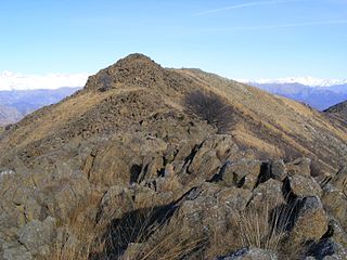
Punta Tre Vescovi is a peak in the Biellese Prealps, in northern Italy. On its top, three valleys meet: Lys Valley, Valsesia, and Valle Cervo.

<span class="mw-page-title-main">Monte Colombano</span> Mountain in Italy

Monte Colombano is a mountain in the Alpi di Lanzo, a sub-group of the Graian Alps, with an elevation of 1,658 m.

<span class="mw-page-title-main">Punta Bagnà</span> Mountain in Italy

Punta Bagnà or Cime du Grand Vallon is a mountain of Savoie, France and of the Province of Turin, Italy. It lies in the Cottian Alps range. It has an elevation of 3,129 metres above sea level.

<span class="mw-page-title-main">Punta Sommeiller</span> Mountain in Italy

Punta Sommeiller or Pointe Sommeiller is a mountain of the Province of Turin, Italy and of Savoie, France. It lies in the Cottian Alps range. It has an elevation of 3,333 metres (10,935 ft) above sea level.

<span class="mw-page-title-main">Monte Bo</span> Mountain in Italy

Monte Bo is a mountain in the Alpi Biellesi, a sub-range of Pennine Alps.

<span class="mw-page-title-main">Colma di Mombarone</span> Mountain in Italy

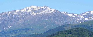
Colma di Mombarone is a mountain of the Biellese Alps, a sub-range of Pennine Alps, in northern Italy. It visually marks, along with Monte Gregorio on the opposite side, the entrance of Aosta Valley from the Po plain. On its top in 1900 was built a huge statue, still located there, of Jesus Christ.

<span class="mw-page-title-main">Bocchetta del Croso</span>

Bocchetta del Croso is a pedestrian pass across the Alpi Biellesi. It connects Cervo valley (BI) and Valsesia (VC), both in Piemonte (Italy).

<span class="mw-page-title-main">Monte Tagliaferro</span> Mountain in Italy

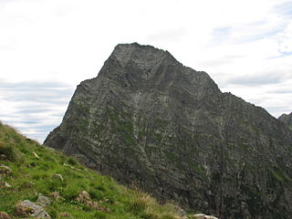
Monte Tagliaferro is a mountain of the Pennine Alps. It is one of the most popular hiking destination of Valsesia.

<span class="mw-page-title-main">Rognosa d'Etiache</span> Mountain in Italy

Rognosa d'Etiache or Rognosa d'Étache is a mountain in the Cottian Alps on the border of Turin, Italy, and Savoie, France. It has an elevation of 3,382 metres above sea level.

<span class="mw-page-title-main">Corno Bianco</span> Mountain in Italy

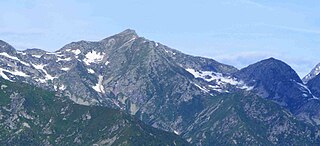
Corno Bianco is a mountain of the Pennine Alps. It's a popular climbing destination of Valsesia.

<span class="mw-page-title-main">Bocchetto Sessera</span>

Bocchetto Sessera or Bocchetto di Sessera is a mountain pass across the Alpi Biellesi. It connects Strona di Mosso Valley and Valsessera, both in the province of Biella.

<span class="mw-page-title-main">Monte Cresto</span> Mountain in Italy

Monte Cresto (2,548 m) is the third highest peak of the Province of Biella after Monte Mars (2,600 m) and Monte Bo (2,556 m).

<span class="mw-page-title-main">Monte Tanarello</span> Mountain in Italy

Monte Tanarello (Italian) or Mont Tanarel (French) is a 2094 metres high mountain located on the French-Italian border.

<span class="mw-page-title-main">Punta Nera</span> Mountain in Italy

The Punta Nera is a mountain of Savoie (France) and of the Province of Turin (Italy). It lies in the Cottian Alps range. It has an elevation of 3,047 metres above sea level.

<span class="mw-page-title-main">Monte Mucrone</span> Mountain in Italy

Monte Mucrone is an Alpine mountain of Piedmont.

<span class="mw-page-title-main">Monte Civrari</span> Mountain in Italy

The Monte Civrari is a mountain of the Graian Alps, with an elevation of 2,302 m.

<span class="mw-page-title-main">Monte I Gemelli</span> Mountain in Italy

The Monte I Gemelli is an Alpine mountain located between Aosta Valley and Piedmont.

<span class="mw-page-title-main">Monte Zeda</span> Mountain in Italy

The Monte Zeda is a mountain in the Lepontine Alps belonging to the Province of Verbano-Cusio-Ossola (Italy).

References

Commons-logo.svg Media related to Monte Barone at Wikimedia Commons

  1. 1 2 Geoportale IGM on www.pcn.minambiente.it
  2. key col: Bocchetta della Boscarola (1,422  m)
  3. Marazzi, Sergio (2005). Atlante Orografico delle Alpi. SOIUSA (in Italian). Priuli & Verlucca. p. 134. ISBN   978-88-8068-273-8.
  4. Monte Barone di Coggiola, route description in italian on www.biellaclub.it (accessed on march the 3rd 2012)
  5. Rifugio Monte Barone - 1610m (Alpe Ponasca, Alta Valsessera), page on www.alpibiellesi.it Archived 2006-05-09 at the Wayback Machine (accessed on march the 3rd 2012)