
Arrone is a comune (municipality) in the Province of Terni in the Italian region Umbria, located about 70 km southeast of Perugia and about 10 km east of Terni in the Valnerina.

Attigliano is a comune (municipality) in the Province of Terni in the Italian region Umbria, located about 70 km south of Perugia and about 30 km west of Terni. Attigliano has the lowest elevation of any municipality located in Umbria.
Baschi is a comune (municipality) in the Province of Terni in the Italian region Umbria, located about 50 km southwest of Perugia and about 35 km northwest of Terni.

Calvi dell'Umbria is a comune (municipality) in the Province of Terni in the Italian region Umbria, located about 80 km south of Perugia and about 20 km southwest of Terni.

Castel Viscardo is a comune (municipality) in the Province of Terni in the Italian region Umbria,

Fabro is a comune (municipality) in the Province of Terni in the Italian region Umbria, located about 40 km southwest of Perugia and about 60 km northwest of Terni.

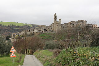
Ferentillo is a comune (municipality) in the Province of Terni in the Italian region Umbria, located about 60 km southeast of Perugia and about 12 km northeast of Terni. The comune, located in the valley of the Nera, is divided by the river into the burghs of Matterella and Precetto.

Ficulle is a comune (municipality) in the Province of Terni in the Italian region Umbria, located about 40 km southwest of Perugia and about 60 km northwest of Terni.

Guardea is a comune (municipality) in the Province of Terni in the Italian region Umbria, located about 60 km south of Perugia and about 30 km west of Terni.
Lugnano in Teverina is a comune (municipality) in the Province of Terni in the Italian region Umbria, located about 60 km south of Perugia and about 25 km west of Terni.

Montecastrilli is a comune (municipality) in the Province of Terni in the Italian region of Umbria, located about 50 km south of Perugia and about 15 km northwest of Terni.
Montecchio is a comune (municipality) in the Province of Terni in the Italian region Umbria, located about 50 km south of Perugia and about 30 km northwest of Terni.

Parrano is a comune (municipality) in the Province of Terni in the Italian region Umbria, located about 35 km southwest of Perugia and about 50 km northwest of Terni.
Penna in Teverina is a comune (municipality) in the Province of Terni in the Italian region Umbria, located about 70 km south of Perugia and about 25 km southwest of Terni.

Polino is a comune (municipality) in the Province of Terni in the Italian region Umbria, located about 70 km southeast of Perugia and about 15 km east of Terni. As of 31 December 2004, it had a population of 275 and an area of 19.5 km2.
Porano is a comune (municipality) in the Province of Terni in the Italian region Umbria, located about 50 km southwest of Perugia and about 45 km northwest of Terni. As of 31 December 2004, it had a population of 1,867 and an area of 13.5 km2.

San Gemini is a comune (municipality) of c. 5,000 inhabitants in the province of Terni in the Italian region Umbria, located about 60 km south of Perugia and about 10 km northwest of Terni.
San Venanzo is a comune (municipality) in the Province of Terni in the Italian region Umbria, located about 30 km (19 mi) southwest of Perugia and about 45 km (28 mi) northwest of Terni.

Borgo Velino is a comune (municipality) in the Province of Rieti in the region Latium, Italy. It is located about 70 kilometres (43 mi) northeast of Rome and about 15 kilometres (9 mi) east of the town Rieti. It has an area of 17.3 square kilometres (6.7 sq mi), and as of 31 December 2010 it had a population of 1,004. Until 1927 Borgo Velino was part of the province of L'Aquila in Abruzzo. It is located near the site of a pre- or early-Roman Sabine village named Viario. Rare ruins of this ancient village, now occupied by a cultivated field, were found near a standing medieval tower. Borgo Velino is the birthplace of Giulio Pezzola, a notorious outlaw of the 17th century.
Castel Sant'Angelo is a comune (municipality) in the Province of Rieti in the Italian region Lazio, located about 70 kilometres (43 mi) northeast of Rome and about 12 kilometres (7 mi) east of Rieti.


