Amelia, Umbria

Last updated
Amelia
Città di Amelia
Amelia 001.JPG
Coat of arms of Amelia.svg
Location of Amelia
Amelia, Umbria
Italy provincial location map 2016.svg
Red pog.svg
Amelia
Location of Amelia in Italy
Italy Umbria location map.svg
Red pog.svg
Amelia
Amelia (Umbria)
Coordinates: 42°33′N12°25′E / 42.550°N 12.417°E / 42.550; 12.417
Country Italy
Region Umbria
Province Terni (TR)
Frazioni Collicello, Foce, Fornole, Macchie, Montecampano, Sambucetole, Porchiano del Monte
Government
  MayorLaura Pernazza
Area
[1]
  Total132 km2 (51 sq mi)
Elevation
406 m (1,332 ft)
Population
 (1 January 2016) [2]
  Total11,897
  Density90/km2 (230/sq mi)
Demonym Amerini
Time zone UTC+1 (CET)
  Summer (DST) UTC+2 (CEST)
Postal code
05022
Dialing code 0744
Patron saint Saint Fermina
Saint dayNovember 24
Website Official website

Amelia is a town and comune located in central Italy which is part of the province of Terni. The city is located in Umbria not far from the border with Lazio. In Antiquity it was known as Ameria.

Contents


Geography

The city of Amelia sits on a defensive rocky spur, and is almost entirely surrounded by ancient Cyclopean walls believed to date from the 7th and the 4th centuries BC).

Situated in the southwest portion of Umbria, the city overlooks the Tiber River to the east and the Nera River to the west. The city is 8 kilometres (5.0 mi) north of Narni, 15 kilometres (9.3 mi) from Orte and approximately 93 kilometres (58 mi) from Perugia. It is about 100 kilometres (62 mi) north of Rome.

History

According to some Italian scholars, Amelia is the oldest town in Umbria. In the third book of his "Naturalis Historia", Pliny the Elder reports a statement made by Cato according to which the origins of the city were said to date back to the period of a mythical Umbrian king called Ameroë, the son of Atlas (hence the name of Ameria, by which the city was known in the ancient time). [3]

In this recording, it is said that that Ameria was founded 963 years before the war with Perseus (171–168 BC), so 1134 BC, a date which is likely unreliable, though the city shows evidence that the hill that forms the nucleus of modern Amelia had already been settled in the eleventh or tenth century.

In its ancient past, the city was subsequently dominated by the Pelasgians, by the Umbrians, and finally by the Etruscans, and later still by the Romans, although it is not mentioned by name in the history of the Roman conquest of Umbria. Ameria occupied a strategic location in the Second Latin War (340–338 BC), lying on a loop of the Via Cassia called the Via Amerina , which started at Falerii and crossed the Tiber at Castellum Amerinum (probably Orte).

By the late fourth or early third century BCE Ameria had likely been granted the status of a municipium as maps of the territory document the Via Amerina extending from Ameria (Amelia) to Perusia (Perugia) at some time in the 3rd century BC. This road is also referred to in the Tabula Peutingeriana, a unique map of the road system for the cursus publicus, the public transport system in use in the Roman Empire. [4]

The town gained political status as a self-governing municipium , possibly as early as 338 BC, but certainly by the middle of the 1st century BC. Citizens of the town were members of the tribus Clustumina. Cicero's speech in defence of Sextus Roscius Amerinus (the pro Roscio Amerino ) describes Ameria as a flourishing place in 80 BC, with a fertile territory extending to the Tiber. Its fruit is often extolled by Roman writers. Augustus divided its lands among his veterans, but did not plant a colony. [5]

The bishopric of Ameria was founded in the middle of the fourth century.

During the barbaric invasions, the city was besieged and badly damaged by the Goths, but was rebuilt by the time the Lombards descended from the north and asserted control over most of what is now Umbria. The Lombards, in turn, were forced out by the Byzantines, and thereafter, throughout the Middle Ages, and up to the time of Italian unification in 1860, Amelia stayed more or less under the domination of the Roman Catholic Church within the Papal States.

During the period when the Lombards remained in control of the Via Flaminia , Amelia was an important stop on a vital alternative route, the so-called Byzantine Way, which connected Rome to the exarchate in Ravenna.

During the Middle Ages, Amelia went through the political convulsions common to other Umbrian cities: struggles that saw it emerge as an independent-minded comune, then as a city under the control of a succession of powerful families, sometimes ecclesiastical, and subject to internecine warfare between Guelphs and Ghibellines.

The campanile of the cathedral was erected in 1050 using fragments of Roman buildings. [5]

Main sights

Polygonal masonry walls in Amelia. Mura2pop.jpg
Polygonal masonry walls in Amelia.

Amelia is especially known for its almost intact, defensive Pre-Roman walls, built by Italic civilizations (Umbrians and Pelasgians) in the centuries between the 6th and 4th BC. The oldest of these are located inside the historic center between the Teatro Sociale and the Porta della Valle. Large segments of these were constructed using polygonal masonry of a type defined as "cyclopean", meaning they are characterized by limestone blocks of considerable size (sometimes exceeding 2 metres), cut with great precision in the shape of irregular polygons and then stacked without using mortar. [5] [6]

A thirty-meter segment of this wall collapsed in 2006 and remains under repair. The walls were further fortified and enlarged during Roman times and at various times during the Middle Ages. [7] The walls run about 720 meters and are about 3.5 meters thick, and have four main gates: the imposing Porta Romana to the south, the main access to the city; Posterola to the north; Porta Leone to the east; and Porta della Valle to the west.

The Romans left other traces of their occupation, including a complex of ten underground cisterns, built in the first century AD, which collected rainwater to feed the city's water supply. There are also snatches of Roman roads within the city, some of them only recently uncovered. A larger-than-life gilt bronze statue of Germanicus was unearthed just outside the Porta Romana in 1963 and is now a featured object of the city's Museo Civico Archeologico. [8]

Bronze statue of Germanicus on display at it:Museo civico di Amelia. Bronze statue of Germanicus at Amelia April 2016.jpg
Bronze statue of Germanicus on display at it:Museo civico di Amelia.

Today, old Amelia inside the walls, which is most accessible through the Porta Romana, is a well-preserved medieval city. The upper part also offers a panoramic view of the Tiber Valley. The center of the city is the Piazza del Duomo where the cathedral and the thirty-meter-high Torre Civica (Civic Tower) are located.

Amelia Cathedral was built originally in 872, and totally rebuilt in Baroque style after a fire in 1629: its façade is of pink cotto and was completed only in the nineteenth century. The interior has works by Federico Zuccari, Lavinia Fontana, Agostino di Duccio, an organ from 1600, and a Turkish banner captured at Lepanto.

Nearby are the Archaeological Museum and the Pinacoteca Comunale (Municipal Gallery), housed in the old Boccarini college.

San Francesco - construction of the church was begun in 1287, is in Piazza Vera, with a cloister and a convent, which was added in the fourteenth century, and renovated with some Renaissance influences in the sixteenth. The church is capped with an impressive dome that dates to the eleventh century and was modified in the seventeenth century. There is also a bell tower, rebuilt in 1932, while the Romanesque-Gothic façade was finished between 1401 and 1406. Inside are housed sculptures by Duccio, and some Baroque material from the seventeenth and eighteenth century; the noteworthy Geraldini Chapel is from the fifteenth century.

The church of Sant'Agostino, consecrated in 1288, has a façade that is an example of Romanesque architecture with a Gothic overlay. The Marotti pipe organ was only installed in 1841. The annexed cloister, designed by the Lombard master Martino Tartaglia in 1492, has a portico surmounted by a loggia with small Corinthian columns. The church of S. Pancrazio features a main door that is a decorative tour-de-force. Of note also is the church of the Madonna delle Cinque Fonti. The now deconsecrated church of S. Giovanni Decollato, also called the Ospedaletto, can be viewed outside.

Along via Posterola is S. Magno, a Benedictine monastery for cloistered nuns. Inside its little church is a perfectly restored and utterly unique (none other exists) double keyboard organ from 1680.

Eighteenth century theater in Amelia. Teatro amelia.jpg
Eighteenth century theater in Amelia.

Among the non-religious buildings there are palaces built during the fourteenth and fifteenth century by the overlords of the city: Palazzo Farrattini and Palazzo Petrignani. The Teatro Operino is an opera house built in the eighteenth century and features frescos by nineteenth-century artist Domenico Bruschi.
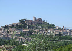
Panorama of Amelia Amelia 1.JPG
Panorama of Amelia

Surrounding area

The hilly countryside around Amelia presents several points of interest. The Convent of the Santissima Annunziata, founded by St. Francis' Friars Minor, has a planetarium. The Cistercians established a convent at Foce, the Sanctuary of the Virgin.

The small fraction of Porchiano del Monte has Medieval walls featuring a number of guard towers, and a small Romanesque church, San Simeone. The church of S. Timoteo, also Romanesque, has fourteenth- and fifteenth-century frescoes.

Fornole is home to the Romanesque church of S. Silvestro, with an interesting fresco cycle showing the saint freeing the town from the grasp of a dragon.

Near the town is the Lago Vecchio ("Old Lake") formed by a dam on a small river, the Rio Grande. Rowing boats can be rented to come around in the shade of alder, poplar and willow trees, looking for sometimes surprised ducks and herons. There is a small park called La Cavallerizza, a former horse racing track, with a walking — or jogging — path around the track, now used for weekend dances and social gatherings.

Festivals and events

The main festival of Amelia is the Palio dei Colombi, which stretches over two weeks in late July and early August. The central event of this palio is a contest during which riders on horseback representing the city's five medieval neighborhoods (contrade) compete against one another in a game of quintain. The winner fires a bolt from a crossbow, hits the target and releases a caged pigeon.

International Academic Partnerships

In 2009, the city of Amelia formed a partnership with the Association for Research into Crimes against Art (ARCA) inviting the researchers to host their professional development Postgraduate Certificate Program in Art Crime and Cultural Heritage Protection, inside the city's 14th century Collegio Boccarini cloister adjacent to the Museo Civico Archeologico. This program is held from late May through mid August annually in the historic center of Amelia in collaboration with the city of Amelia.

Twin towns

Related Research Articles

<span class="mw-page-title-main">Umbria</span> Region of Italy

Umbria is a region of central Italy. It includes Lake Trasimeno and Marmore Falls, and is crossed by the Tiber. It is the only landlocked region on the Apennine Peninsula. The regional capital is Perugia.

<span class="mw-page-title-main">Spoleto</span> Comune in Umbria, Italy

Spoleto is an ancient city in the Italian province of Perugia in east-central Umbria on a foothill of the Apennines. It is 20 km (12 mi) south of Trevi, 29 km (18 mi) north of Terni, 63 km (39 mi) southeast of Perugia; 212 km (132 mi) southeast of Florence; and 126 km (78 mi) north of Rome.

Via Flaminia Ancient Roman road

The Via Flaminia was an ancient Roman road leading from Rome over the Apennine Mountains to Ariminum (Rimini) on the coast of the Adriatic Sea, and due to the ruggedness of the mountains was the major option the Romans had for travel between Etruria, Latium, Campania, and the Po Valley. The section running through northern Rome is where Constantine the Great, allegedly, had his famous vision of the Chi Rho, leading to his conversion to Christianity and the Christianization of the Roman Empire.

<span class="mw-page-title-main">Ascoli Piceno</span> Town in Marche, Italy

Ascoli Piceno is a comune (municipality) and capital of the province of Ascoli Piceno, in the Marche region of Italy.

<span class="mw-page-title-main">Todi</span> Comune in Umbria, Italy

Todi is a town and comune (municipality) of the province of Perugia in central Italy. It is perched on a tall two-crested hill overlooking the east bank of the river Tiber, commanding distant views in every direction. It was founded in antiquity by the Umbri, at the border with Etruria; the gens Ulpia of Roman emperor Trajan came from Todi.

<span class="mw-page-title-main">Bevagna</span> Comune in Umbria, Italy

Bevagna is a town and comune in the central part of the Italian province of Perugia (Umbria), in the flood plain of the Topino river.

<span class="mw-page-title-main">Narni</span> Comune in Umbria, Italy

Narni is an ancient hilltown and comune (municipality) of Umbria, in central Italy, with 19,252 inhabitants (2017). At an altitude of 240 metres (790 ft), it overhangs a narrow gorge of the River Nera in the province of Terni. It is very close to the geographical centre of Italy. There is a stone on the exact spot with a sign in multiple languages.

<span class="mw-page-title-main">Province of Terni</span> Province of Italy

The province of Terni is the smaller of the two provinces in the Umbria region of Italy, comprising one-third of both the area and population of the region. Its capital is the city of Terni. The province came into being in 1927, when it was carved out of the original unitary province of Umbria.

<span class="mw-page-title-main">Trevi, Umbria</span> Comune in Umbria, Italy

Trevi is an ancient town and comune (municipality) in Umbria, Italy, on the lower flank of Mount Serano overlooking the wide plain of the Clitunno river system. Located in the Province of Perugia, it is 10 km (6 mi) SSE of Foligno and 20 km (12 mi) north of Spoleto. It is one of I Borghi più belli d'Italia.

<span class="mw-page-title-main">Spello</span> Comune in Umbria, Italy

Spello is an ancient town and comune (township) of Italy, in the province of Perugia in eastern-central Umbria, on the lower southern flank of Mt. Subasio. It is 6 km (4 mi) NNW of Foligno and 10 km (6 mi) SSE of Assisi. It is one of I Borghi più belli d'Italia.

<span class="mw-page-title-main">Montefalco</span> Comune in Umbria, Italy

Montefalco is a historic small hill town in Umbria, Italy, with a population of 5,581 in August 2017. It has been settled since pre-Roman times, and retains many of its historic buildings. From 1446 to 1861 it was part of the Papal States. It is one of I Borghi più belli d'Italia.

<span class="mw-page-title-main">Pigge</span> Frazione in Umbria, Italy

Pigge or Lapigge is a village in the Italian province of Perugia in east central Umbria, stretching from the plain of the Clitunno river up the lower SW flank of Mt. Serano, at 297 m above sea-level. It is a frazione of the comune of Trevi, which is 3 km NNW. Its population was 463 in 2003.

<span class="mw-page-title-main">Otricoli</span> Comune in Umbria, Italy

Otricoli is a town and comune in the province of Terni, Umbria, central Italy. It is located on the Via Flaminia, near the east bank of the Tiber, some 70 km north of Rome and 20 km south of Narni.

<span class="mw-page-title-main">Umbri</span> Italic people of ancient Italy

The Umbri were an Italic people of ancient Italy. A region called Umbria still exists and is now occupied by Italian speakers. It is somewhat smaller than the ancient Umbria.

<span class="mw-page-title-main">Sabina (region)</span> Traditional region in Italy

Sabina, also called the Sabine Hills, is a region in central Italy. It is named after Sabina, the territory of the ancient Sabines, which was once bordered by Latium to the south, Picenum to the east, ancient Umbria to the north and Etruria to the west. It was separated from Umbria by the River Nar, today's Nera, and from Etruria by the River Tiber.

<span class="mw-page-title-main">Monte Castello di Vibio</span> Comune in Umbria, Italy

Monte Castello di Vibio is a comune (municipality) in the Province of Perugia in the Italian region Umbria, located about 30 kilometres (19 mi) south of Perugia. Monte Castello di Vibio borders the following municipalities: Fratta Todina, San Venanzo, Todi.

<span class="mw-page-title-main">Lugnano in Teverina</span> Comune in Umbria, Italy

Lugnano in Teverina is a comune (municipality) in the Province of Terni in the Italian region Umbria, located about 60 km south of Perugia and about 25 km west of Terni.

<span class="mw-page-title-main">Cesi, Terni</span>

Cesi is a frazione of the Italian comune of Terni, in the province of Terni, southern Umbria, Italy. The small borgo, which retains its late-medieval aspect, set among olive groves, lies "stretched out lengthwise along a narrow contour on the slopes of M. Torre Maggiore," about 18 km north of Terni at an altitude of 437 m, one of the southernmost peaks of the Monti Martani. As of 2001 there were 682 residents.


Civitella d'Arna is a frazione of the comune (municipality) of Perugia in central Italy, and the Ancient city and former bishopric Arna, which remains a Latin Catholic titular see.

<span class="mw-page-title-main">Cathedral of Nocera Umbra</span> Church in Umbria, Italy

The church of Saint Maria Assunta is a Catholic parish church in Nocera Umbra, in Umbria, and co-cathedral of the diocese of Assisi-Nocera Umbra-Gualdo Tadino.

References

  1. "Superficie di Comuni Province e Regioni italiane al 9 ottobre 2011". Italian National Institute of Statistics. Retrieved 16 March 2019.
  2. "Popolazione Residente al 1° Gennaio 2018". Italian National Institute of Statistics. Retrieved 16 March 2019.
  3. Pliny the Elder, Historia Naturalis, vol. 3
  4. "Tabula Peutingeriana ca. 250". Bibliotheca Agustana. Retrieved 1 March 2024.
  5. 1 2 3 Wikisource-logo.svg One or more of the preceding sentences incorporates text from a publication now in the public domain :  Chisholm, Hugh, ed. (1911). "Ameria". Encyclopædia Britannica . Vol. 1 (11th ed.). Cambridge University Press. p. 805.
  6. Ruggero Lenci (2019). L'enigma dell'opera poligonale con blocchi concavi e il rilievo delle mura di Amelia-The enigma of the polygonal work with concave blocks and the survey of the walls of Amelia. Ediz. illustrata. Gangemi. ISBN   978-88-492-3718-4.
  7. Lorenzo Quilici; Stefania Quilici Gigli (1997). Architettura e pianificazione urbana nell'Italia antica. L'ERMA di BRETSCHNEIDER. pp. 92–. ISBN   978-88-8265-007-0.
  8. Lindsay Powell (25 September 2013). Germanicus: The Magnificent Life and Mysterious Death of Rome's Most Popular General. Pen and Sword. pp. 37–. ISBN   978-1-4738-2692-2.