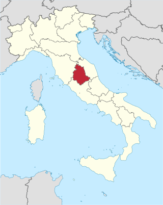
Umbria is a region of central Italy. It includes Lake Trasimeno and Marmore Falls, and is crossed by the Tiber. It is the only landlocked region on the Apennine Peninsula. The regional capital is Perugia.

Terni is a city in the southern portion of the region of Umbria, in Central Italy. It is near the border with Lazio. The city is the capital of the province of Terni, located in the plain of the River Nera. It is 104 kilometres northeast of Rome and 81 km south of the regional capital, Perugia.

Spoleto is an ancient city in the Italian province of Perugia in east-central Umbria on a foothill of the Apennines. It is 20 km (12 mi) south of Trevi, 29 km (18 mi) north of Terni, 63 km (39 mi) southeast of Perugia; 212 km (132 mi) southeast of Florence; and 126 km (78 mi) north of Rome.

Città di Castello ; "Castle Town") is a city and comune in the province of Perugia, in the northern part of Umbria. It is situated on a slope of the Apennines, on the flood plain along the upper part of the river Tiber. The city is 56 km (35 mi) north of Perugia and 104 km (65 mi) south of Cesena on the motorway SS 3 bis. It is connected by the SS 73 with Arezzo and the A1 highway, situated 38 km (23 mi) west. The comune of Città di Castello has an exclave named Monte Ruperto within Marche.

Narni is an ancient hilltown and comune (municipality) of Umbria, in central Italy, with 19,252 inhabitants (2017). At an altitude of 240 metres (790 ft), it overhangs a narrow gorge of the River Nera in the province of Terni. It is very close to the geographical centre of Italy. There is a stone on the exact spot with a sign in multiple languages.

The province of Terni is the smaller of the two provinces in the Umbria region of Italy, comprising one-third of both the area and population of the region. Its capital is the city of Terni. The province came into being in 1927, when it was carved out of the original unitary province of Umbria.
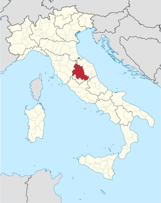
The province of Perugia is the larger of the two provinces in the Umbria region of Italy, comprising two-thirds of both the area and population of the region. Its capital is the city of Perugia. The province covered all of Umbria until 1927, when the province of Terni was carved out of its southern third. The province of Perugia has an area of 6,334 km2 covering two-thirds of Umbria, and a total population of about 660,000. There are 59 comuni in the province. The province has numerous tourist attractions, especially artistic and historical ones, and is home to the Lake Trasimeno, the largest lake of Central Italy. It is historically the ancestral origin of the Umbri, while later it was a Roman province and then part of the Papal States until the late 19th century.

Spello is an ancient town and comune (township) of Italy, in the province of Perugia in eastern-central Umbria, on the lower southern flank of Monte Subasio. It is 6 km (4 mi) NNW of Foligno and 10 km (6 mi) SSE of Assisi. It is one of I Borghi più belli d'Italia.
Cascia is a town and comune (municipality) of the Italian province of Perugia in a rather remote area of the mountainous southeastern corner of Umbria. It is about 21 km from Norcia on the road to Rieti in the Lazio (63 km). It is also very close to Terni.

Otricoli is a town and comune in the province of Terni, Umbria, central Italy. It is located on the Via Flaminia, near the east bank of the Tiber, some 70 km north of Rome and 20 km south of Narni.

Hispellum was an ancient town of Umbria, Italy, 6 km (3.7 mi) north of Fulginiae on the road to Perusia.

The Umbri were an Italic people of ancient Italy. A region called Umbria still exists and is now occupied by Italian speakers. It is somewhat smaller than the ancient Umbria.

Allerona is a comune (municipality) in the Province of Terni in the Italian region Umbria, located about 50 km southwest of Perugia and about 60 km northwest of Terni. It is one of I Borghi più belli d'Italia. The town consists of Allerona Alta, the hill town, and Allerona Scalo, the more populated town with a few bars, restaurants, grocers, and other services. The land is a mix of sand and clay soils, representing an ancient coastline where fossilized seashells can be found dating back a million years in the ancient sand dunes. Along the river that meanders on the valley west of the Autostrada, is an ancient Roman road. The fog settled in the valley quite often, leaving the hilltop village visible at a distance.

Attigliano is a comune (municipality) in the Province of Terni in the Italian region Umbria, located about 70 km south of Perugia and about 30 km west of Terni. Attigliano has the lowest elevation of any municipality located in Umbria.

Ferentillo is a comune (municipality) in the Province of Terni in the Italian region Umbria, located about 60 km southeast of Perugia and about 12 km northeast of Terni. The comune, located in the valley of the Nera, is divided by the river into the burghs of Matterella and Precetto.

San Gemini is a comune (municipality) of c. 5,000 inhabitants in the province of Terni in the Italian region Umbria, located about 60 km south of Perugia and about 10 km northwest of Terni.
Vacone is a comune (municipality) in the Province of Rieti in the Italian region of Latium, located about 20 kilometres (12 mi) west of Rieti.

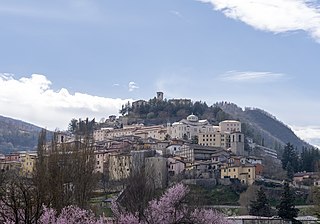
Cesi is a frazione of the Italian comune of Terni, in the province of Terni, southern Umbria, Italy. The small borgo, which retains its late-medieval aspect, set among olive groves, lies "stretched out lengthwise along a narrow contour on the slopes of M. Torre Maggiore," about 18 km north of Terni at an altitude of 437 m, one of the southernmost peaks of the Monti Martani. As of 2001 there were 682 residents.

David Soren is an American archaeologist and former vaudeville performer.
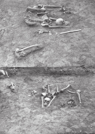
A vampire burial or anti-vampire burial is a burial performed in a way which was believed to prevent the deceased from reviving in the form of a vampire or to prevent an "actual" vampire from revenance.


