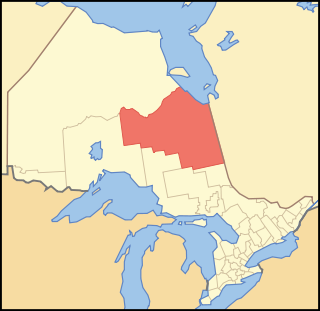
Cochrane District is a district and census division in Northeastern Ontario in the Canadian province of Ontario. It was created in 1921 from parts of Timiskaming and Thunder Bay districts.

Cumberland House is a community in Census Division No. 18 in northeast Saskatchewan, Canada on the Saskatchewan River. It is the oldest settler community in Saskatchewan and has a population of about 2,000 people. Cumberland House Provincial Park, which provides tours of an 1890s powder house built by the Hudson's Bay Company, is located nearby.

Flying Dust First Nation is a Cree First Nation band government located adjacent to the city of Meadow Lake in Saskatchewan, Canada. Highway 55 goes though the band's reserve community.

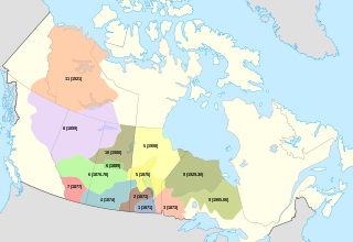
Division No. 15 is one of eighteen census divisions in the province of Saskatchewan, Canada, as defined by Statistics Canada. It is located in the north-central part of the province. The most populous community in this division is Prince Albert.

Lac Brochet is a First Nation community in the boreal forest of northern Manitoba, Canada. The village is located on the north shore of Lac Brochet.

Wawakapewin First Nation is an Oji-Cree First Nation reserve located 350 kilometers north of Sioux Lookout, Ontario. It is only accessible by air and the winter road system from Pickle Lake. It is a small community in which the registered population in June 2013 was 73, of which 43 lived on their own Reserve. The current Chief is Anne-Marie Beardy. Wawakapewin First Nation is a member of Shibogama First Nations Council.

Bearskin Lake First Nation is an Oji-Cree First Nation reserve in Kenora District, Ontario, Canada, located 425 kilometres (264 mi) north of Sioux Lookout. Bearskin First Nation's total registered population as of March 2014 was 900, of which their on-reserve population was 461.

Sandy Lake First Nation is an independent Oji-Cree First Nations band government. The First Nations community, in the west part of Northern Ontario, is located in the Kenora District, 227 km (141 mi) northeast of Red Lake, Ontario. Its registered population in June 2007 was 2,474. As of December 2015 the total registered population reached 3,034. Sandy Lake First Nation maintains an affiliation with Nishnawbe Aski Nation, as a signatory to the Treaty 5.

Duck Lake is a town in the boreal forest of central Saskatchewan, Canada. Its location is 88 km (55 mi) north of Saskatoon and 44 km (27 mi) south of Prince Albert on highway 11, in the rural municipality of Duck Lake. Immediately to the north of Duck Lake is the south block of the Nisbet Provincial Forest.
Kasabonika Lake First Nation or Kasabonika First Nation is an Oji-Cree First Nations band government located north of Sioux Lookout, Ontario. There are no roads into the community and the only access is through Kasabonika Airport. It is part of the Shibogama First Nations Council and the Nishnawbe Aski Nation. The First Nation's landbase is the 10,806.5-hectare (26,703.4-acre) Kasabonika Lake Reserve.
McDowell Lake First Nation is a small Oji-Cree First Nation band government located in Northern Ontario, located approximately 155 km northeast of Red Lake, Ontario, Canada, on the central western shore of McDowell Lake. As of December, 2007, their total registered population was 52. It is part of the Keewaytinook Okimakanak Council and the Nishnawbe Aski Nation.

Fond du Lac Dene Nation is a Dene First Nation located in the boreal forest area of northern Saskatchewan, Canada. The main settlement is Fond-du-Lac, situated on the east side of Lake Athabasca. It is a remote fly-in community. The population in 2011 was 874, mainly of Dene and Métis descent. 705 residents selected Dene as their mother tongue in 2011.

Canoe Lake 165 is an Indian reserve of the Canoe Lake Cree First Nation in the boreal forest of northern Saskatchewan, Canada. Its location is on Canoe Lake approximately thirty miles west of Beauval, within ancient hunting grounds of the Woodland Cree. The reserve includes the settlement of Canoe Narrows.
Debden is a village within the Rural Municipality of Canwood No. 494, within the boreal forest of central Saskatchewan, Canada. The village is location is on Highway 55 and is 94 km from the city of Prince Albert and 194 km from the city of Saskatoon. It is also the administrative headquarters of the Big River Cree First Nations band government.
North Caribou Lake First Nation or Weagamow First Nation, sometimes also known as Round Lake First Nation, is an Oji-Cree First Nations band government who inhabit the Kenora District in northern Ontario, Canada. It is approximately 320 km (200 mi) by air north of Sioux Lookout. As of January 2008, the First Nations had a registered population of 928 people, of which their on-Reserve population was 677.
Ahtahkakoop First Nation is a Cree First Nation band government in Shell Lake, Saskatchewan, Canada. The Ahtahkakoop First Nation government and community is located on Ahtahkakoop 104, 72 kilometers northwest of Prince Albert and is 17,347 hectares in size.
Black Lake is a Denesuline First Nations band government in the boreal forest of northern Saskatchewan, Canada. It is located on the northwest shore of Black Lake where the Fond du Lac River leaves the lake to flow to Lake Athabasca.

Hatchet Lake Dene Nation is a Dene First Nation in northern Saskatchewan. The main settlement, Wollaston Lake, is an unincorporated community on Wollaston Lake in the boreal forest of northeastern Saskatchewan, Canada.

Barren Lands First Nation is a First Nation located on the north shore of Reindeer Lake in northern Manitoba close to the Saskatchewan border. It has one territory called Brochet 197 which is 4339.40 hectares in size and adjoins the village of Brochet, Manitoba.
The Mathias Colomb First Nation, Mathias Colomb Cree Nation (MCCN), Mathias Colomb (Cree) First Nation, Pukatawagan/Mathias Colomb Cree Nation is a remote northern Manitoba First Nations, located 210 km (130 mi) north of The Pas and 819 km (509 mi) northwest of Winnipeg, Manitoba, which had two reserves under its jurisdiction, Indian Rreserve (IR) 198 and IR No. 199. They are part of the Treaty 6 and the main community is at Pukatawagan and consists of 1,536.6 ha on the shore of Pukatawagan Lake and lies about 210 km (130 mi) north of The Pas. Their second reserve was the Highrock reserve (CSD) located on Highrock Lake, 30 km (19 mi) downstream from Pukatawagan, which was dissolved by 2006.