Montrond | |
|---|---|
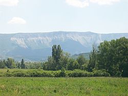 The Montagne de Chabre, seen from the RN75 road, in the area of Montrond | |
 Coat of arms | |
 Location of Montrond | |
 Montrond  Montrond | |
| Coordinates: 44°22′57″N5°44′29″E / 44.3825°N 5.7414°E | |
| Country | France |
| Region | Provence-Alpes-Côte d'Azur |
| Department | Hautes-Alpes |
| Arrondissement | Gap |
| Canton | Serres |
| Government | |
| • Mayor (2020–2026) | Alain Roumieu [1] |
Area 1 | 4.46 km2 (1.72 sq mi) |
| Population (2023) [2] | 90 |
| • Density | 20/km2 (52/sq mi) |
| Time zone | UTC+01:00 (CET) |
| • Summer (DST) | UTC+02:00 (CEST) |
| INSEE/Postal code | 05089 /05700 |
| Elevation | 605–822 m (1,985–2,697 ft) (avg. 625 m or 2,051 ft) |
| 1 French Land Register data, which excludes lakes, ponds, glaciers > 1 km2 (0.386 sq mi or 247 acres) and river estuaries. | |
Montrond is a commune in the Hautes-Alpes department in southeastern France.