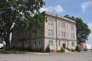
Moore County is a county located in the U.S. state of North Carolina. As of the 2020 census, its population was 99,727. Its county seat is Carthage and its largest community Pinehurst. It is a border county between the Piedmont and the Atlantic Coastal Plain.

Hayesville is a town in Clay County, North Carolina, United States. The population was 311 at the 2010 census. It is the county seat of Clay County.

Pinehurst, known formally as The Village of Pinehurst, is a village in Moore County, North Carolina, United States. As of the 2020 census, the village population was 17,581. Pinehurst refers to both the village, and the Pinehurst Resort, a Golf resort, which has hosted multiple United States Open Championships in the sport. A large portion of the central village, including the resort complexes, is a National Historic Landmark District, designated in 1996 for its landscape design by Frederick Law Olmsted and its significance in the history of golf in the United States. Pinehurst has been designated as the "Home of American Golf" by the United States Golf Association and by the State of North Carolina. The surrounding area is known for its strong equestrian community, including the former Stoneybrook Steeplechase, and the current Pinehurst Harness Track. Fox hunting is also a common sport in the area.
Southern Pines is a town in Moore County, North Carolina, United States. The population was 12,334 as of the 2010 United States Census.

Vass is a town in Moore County, North Carolina, United States. The population was 952 at the 2020 census. Vass grew up along the railroad in the late 19th century. It was originally named Bynum and later Winder before being established as Vass in 1892. The town was incorporated in 1907.

Hanging Rock State Park is a 9,011-acre (3,647 ha) North Carolina state park in Stokes County, North Carolina in the United States. The park is 30 miles (48 km) north of Winston-Salem and is located approximately 2 miles (3.2 km) from Danbury in Stokes County.

Horne Creek Farm is a historical farm near Pinnacle, Surry County, North Carolina. The farm is a North Carolina State Historic Site that belongs to the North Carolina Department of Natural and Cultural Resources, and it is operated to depict farm life in the northwest Piedmont area c. 1900. The historic site includes the late 19th century Hauser Farmhouse, which has been furnished to reflect the 1900-1910 era, along with other supporting structures. The farm raised animal breeds that were common in the early 20th century. The site also includes the Southern Heritage Apple Orchard, which preserves about 800 trees of about 400 heritage apple varieties. A visitor center includes exhibits, a gift shop and offices.

The Dismal Swamp Canal is a canal located along the eastern edge of the Great Dismal Swamp in Virginia and North Carolina in the United States. Opened in 1805, it is the oldest continually operating man-made canal in the United States. It is part of the Intracoastal Waterway.

Heceta Head Light is a lighthouse on the Oregon Coast 13 miles (21 km) north of Florence, and 13 miles (21 km) south of Yachats in the United States. It is located at Heceta Head Lighthouse State Scenic Viewpoint, a state park, midway up a 205-foot-tall (62 m) headland. Built in 1894, the 56-foot (17 m)-tall lighthouse shines a beam visible for 21 nautical miles, making it the strongest light on the Oregon Coast.

Moore's Crossing Historic District is a community located in rural Travis County nine miles southeast of Austin, Texas near the Austin–Bergstrom International Airport.

Copper Falls State Park is a 3,068-acre (1,242 ha) state park in Wisconsin. The park contains a section of the Bad River and its tributary the Tylers Forks, which flow through a gorge and drop over several waterfalls. Old Copper Culture Indians and later European settlers mined copper in the area. The state park was created in 1929 and amenities were developed by the Civilian Conservation Corps and the Works Progress Administration. In 2005 the park was listed on the National Register of Historic Places as a site with 10 contributing properties.
Lone Pine is a historic home and national historic district located near Tarboro, Edgecombe County, North Carolina. The district encompasses eight contributing buildings associated with the Lone Pine tobacco farm complex. The house was built about 1860, and is a two-story, rectangular, weatherboarded frame dwelling with Greek Revival and Italianate style design elements. It has a hipped tin roof pierced by two interior chimneys and a hipped tetrastyle portico. Also on the property are several structures and two contributing frame tobacco barns.

John Henry Kapp Farm is a historic farm complex and national historic district located near Bethania, Forsyth County, North Carolina. The district encompasses seven contributing buildings, one contributing site, and four contributing structures dated between about 1870 and 1942. They include a two-story, frame, vernacular I-house ; smokehouse; storage shed ; shop ; chicken house (1920s); corn crib / granary; barn (1870s); fence ; corn crib / granary ; tenant house ; tobacco pack house ; and the agricultural landscape.

Garner Farm is a historic farm and national historic district located near Days Crossroads, Halifax County, North Carolina. It encompasses three contributing buildings and one contributing site, the farm landscape. The farmhouse, commonly known as “The Big House” to the family, was built between 1900 and 1902, and is a "triple-A" I-house, three bays wide, with an original one-story rear ell. It has a gable roof with interior end chimneys and pedimented gable ends. The house was modernized in the 1940s. Also on the property is a contributing kitchen and packhouse.
Allison Woods is a historic rural retreat and national historic district located near Statesville, Iredell County, North Carolina. It encompasses six contributing buildings, four contributing sites, and three contributing structures on a gentleman's farm developed by William Locke Allison between about 1926 and 1939. The district includes natural woodlands and water features and the developed landscape to include the stream course with impoundments and Lower Lake. The built features are of brick or stone construction, with some representative of the Bungalow / American Craftsman style. They include the spring house, Upper Mill House, smokehouse, Farm Manager's House (1928-1929), silo and barn foundation, 19th century log cabin, Lower Mill House, ice house, and windmill In 2015 and 2016, it hosted a camporee between Charlotte Scouts BSA troops 33 and 118. Troop 118 won both years.

Tull–Worth–Holland Farm is a historic farm and national historic district located near Kinston, Lenoir County, North Carolina. It encompasses 14 contributing buildings and 1 contributing site. The district includes a significant cross section of domestic and agricultural buildings constructed between 1825 and 1942. The farmhouse was built about 1825, and is a two-story, Federal style frame dwelling. It has a gable roof, exterior end chimneys, and hall-and-parlor plan. Other contributing resources are the Cook's House, privy / chicken house, Delco house, playhouse, barn, stable, cotton gin, five tobacco barns, and a tenant house.

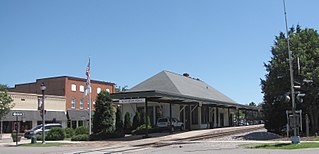
Southern Pines Historic District is a national historic district located at Southern Pines, Moore County, North Carolina. The district encompasses 490 contributing buildings, 2 contributing sites, and 3 contributing structures in the town of Southern Pines. It was developed between the 1883 and 1940 and includes notable examples of Queen Anne, Colonial Revival, and Bungalow / American Craftsman style architecture. Located in the district is the separately listed James Boyd House. Other notable buildings include Duncraig Manor, Loblolly, Seaboard Air Line Passenger Depot, Seaboard Air Line Freight Station, Sadelson Pharmacy-Tourist Building, Powell Furniture and Undertaking Building, Belvedere Hotel Building (1904), Arcade Building (1917), Princess Theatre / Carolina Theatre Building, Southern Pines Public Library (1939), U. S. Post Office (1937), First Baptist Church (1899), Church of Wide Fellowship (1927), and Emmanuel Episcopal Church (1926).
The McLeod Family Rural Complex is a historic farm and national historic district located near Pine Bluff, Moore County, North Carolina, United States. The district encompasses 10 contributing buildings, 1 contributing site, and 3 contributing structures on a family farm established in the mid-19th century. It includes two houses: the John McLeod House, a largely intact, 1+1⁄2-story, frame dogtrot plan house dated to about 1840. The Alex McLeod House, built in 1884, is a two-story, five-bay, traditional frame farmhouse. Other contributing resources include two tobacco barns, a packing house, a fertilizer house, a barn with stables, a corn crib, a saddle-notched log house, a chicken house, a shed, a root cellar, and a smokehouse.
Firleigh Farms is a historic equine and fox hunting estate located near Southern Pines, Moore County, North Carolina. Firleigh was built in 1923–1924, and is a two-story, Colonial Revival style frame dwelling. It consists of a five-bay main block and a two-story ell forming an L-shaped plan. It was built as a winter-season hunting box for Augustine Healy and his wife, Jeanette Reid Healy. Also on the property is a contributing three-vehicle garage/servants's quarters.
Dupree–Moore Farm, also known as the Thomas Dupree House, is a historic home and tobacco farm located near Falkland, Pitt County, North Carolina. The house was built between about 1800 and 1825, as a 1+1⁄2-story, three-bay, frame dwelling. It was enlarged to two stories and rear additions added and remodeled in the Greek Revival style about 1848. A two-story rear "T" addition was added about 1861. The house features a one-story full-width shed-roof front porch with Picturesque-style latticework. Also on the property are the contributing smokehouse, tobacco grading house, pump house/utility shed, frame equipment shelter, mule barn, tobacco packhouse, tenant house, tenant tobacco packhouse, sweet potato house, log tobacco barn, tobacco barn, and tobacco packhouse.


