Mosherville, Michigan

Last updated

Mosherville, Michigan
Mosherville, Michigan (2022).jpg
Intersection of Winfield Road and North Street
USA Michigan location map.svg
Red pog.svg
Mosherville
Location within the state of Michigan
Usa edcp location map.svg
Red pog.svg
Mosherville
Location within the United States
Coordinates: 42°03′37″N84°39′34″W / 42.06028°N 84.65944°W / 42.06028; -84.65944
Country Flag of the United States.svg United States
State Flag of Michigan.svg  Michigan
County Hillsdale
Township Scipio
Settled1838
Platted 1852
Elevation
850 ft (260 m)
Time zone UTC-5 (Eastern (EST))
  Summer (DST) UTC-4 (EDT)
ZIP code(s)
49250 (Jonesville)
49258
Area code 517
GNIS feature ID632744 [1]

Mosherville is an unincorporated community in Hillsdale County in the U.S. state of Michigan. [1] The community is located within Scipio Township.

Contents

As an unincorporated community, Mosherville has no legally defined boundaries or population statistics of its own but does have its own post office with the 49258 ZIP Code, which is primarily used for post office box services. [2] [3]

Geography

Signage along W. Mosherville Road Mosherville, MI road signage.jpg
Signage along W. Mosherville Road

Mosherville is located in northern Scipio Township in north-central Hillsdale County about 25 miles (40 km) southeast of Coldwater. [4]

Mosherville is located about 0.5 miles (0.8 km) south of the county line with Jackson County. The rural community is not served by any major highways or airports. Nearby cities include Litchfield to the west and Jonesville to the south. The village of Hanover is located to the northeast. Other nearby unincorporated communities include Pulaski to the north, Stoney Point to the northeast, and Moscow to the east.

Mosherville Lake is the largest lake within the community, and there are several smaller unnamed lakes nearby. [5] The south branch of the Kalamazoo River flows directly through the community. [6] The new Scipio Township Hall is located within Mosherville at 11180 Concord Road just east of the center of the community. [7] The community is served by Jonesville Community Schools to the south in the city of Jonesville. [8]

The Mosherville post office is located at 11200 Winfield Road in the center of the community. [9] The post office uses the 49258 ZIP Code, which is primarily used for post office box services. [2] [3] For delivery, the surrounded area is served by the Jonesville post office, which uses the 49250 ZIP Code. [10] [11]

History

Historic image of Mosherville in 1914 Mosherville, Michigan 1914.jpg
Historic image of Mosherville in 1914

This northern area of Scipio Township was first settled as early as 1838 by New York native David Mosher. His brothers Charles, James, and Giles would also later move to the area. David returned to New York, while his brothers remained and built a sawmill and grist mill. A post office first opened on July 2, 1849 and was named Scipio after the township. Samuel E. Smith served as the first postmaster. The community was platted in 1852 and later expanded in 1856, and the post office was briefly renamed Tylerville. The community appeared under the name Mosherville on an 1857 map of Hillsdale County, and the post office was ultimately renamed Mosherville on April 20, 1858. [12] [13]

In 1899, the Omega Portland Cement Company began operating in Mosherville along Cobb Lake, which is located just southeast of the community. [14] The numerous small lakes in the area were rich in sediments necessary to produce Portland cement, and the company built several buildings in Mosherville. The sediments were dredged from the nearby lakes and transported to Millbury, Ohio for further processing. This company ceased operation in 1914. [15] [16]

Mosherville once had a train station along the Fort Wayne and Jackson Railroad branch of the New York Central Railroad. The station operated as late as 1923, but the station and train tracks are no longer present in Mosherville. [17] East Mosherville was another community settled just to the east and also had its own train station. This community appeared on an 1872 and 1911 maps of Hillsdale County. [18] [19] While Mosherville continues to exist as an unincorporated community, East Mosherville has effectively become a ghost town. [20]

Mosherville Church and School Complex

The most notable historic structures within the community are the Mosherville Church and Mosherville School. They were designated a Michigan State Historic Site as the Mosherville Church and School Complex on April 24, 1979. The next year, the state erected a dual-sized historic marker describing the two structures.

The church is located at 1520 North Street and was originally constructed from 1861–1862 on land donated by Joseph and Mary Riggs. The church was a Litchfield branch that served as a Methodist Episcopal Church, and it began operating independently in 1870. In 1891, the church was also used by the Ladies' Aid Society, which expanded the church. The Mosherville Church remains in operation and holds weekly non-denominational services.

The Mosherville School began operating in 1847 and built its first school in 1857–1858. In 1872, the current structure was built next to the church at a cost of $2,800. As the oldest school in Scipio Township, it served as a two-room schoolhouse that taught students in grades one through ten. Later serving as only an eighth grade school, it closed in 1967. Afterward, it was used by the Ladies' Aid Society and currently serves as a fellowship hall with the Mosherville Church. [21] [22] [23]

Images

Related Research Articles

<span class="mw-page-title-main">Mikado Township, Michigan</span> Civil township in Michigan, United States

Mikado Township is a civil township of Alcona County in the U.S. state of Michigan. The population was 947 at the 2010 census.

<span class="mw-page-title-main">Moscow Township, Michigan</span> Civil township in Michigan, United States

Moscow Township is a civil township of Hillsdale County in the U.S. state of Michigan. The population was 1,467 at the 2020 census.

<span class="mw-page-title-main">Scipio Township, Michigan</span> Civil township in Michigan, United States

Scipio Township is a civil township of Hillsdale County in the U.S. state of Michigan. The population was 1,902 at the 2020 census.

<span class="mw-page-title-main">Newport, Michigan</span> Unincorporated community in Michigan, United States

Newport is an unincorporated community in Monroe County in the U.S. state of Michigan. The community is located within Berlin Charter Township. As an unincorporated community, Newport has no legally defined boundaries or population statistics of its own but does have its own post office with the 48166 ZIP Code.

<span class="mw-page-title-main">Topinabee, Michigan</span> Unincorporated community in Michigan, United States

Topinabee is an unincorporated community in Cheboygan County in the U.S. state of Michigan. The community is located within Mullet Township along the southwestern shores of Mullett Lake.

<span class="mw-page-title-main">Pittsford, Michigan</span> Census-designated place & unincorporated community in Michigan, United States

Pittsford is an unincorporated community and census-designated place (CDP) in Hillsdale County in the U.S. state of Michigan. The population of the CDP was 553 at the 2020 census. The community is located along M-34 on the border between Jefferson Township to the west and Pittsford Township to the east.

<span class="mw-page-title-main">Osseo, Michigan</span> Unincorporated community in Michigan, United States

Osseo is an unincorporated community in Hillsdale County in the U.S. state of Michigan. The community is located along M-34 within Jefferson Township.

<span class="mw-page-title-main">Jerome, Michigan</span> Unincorporated community in Michigan, United States

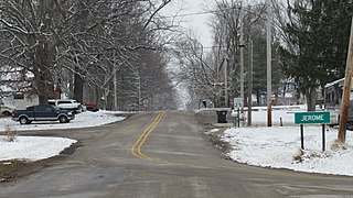
Jerome is an unincorporated community in Hillsdale County in the U.S. state of Michigan. The community is located within Somerset Township.

<span class="mw-page-title-main">Somerset Center, Michigan</span> Unincorporated community in Michigan, United States

Somerset Center is an unincorporated community in Hillsdale County in the U.S. state of Michigan. The community is located along U.S. Highway 12 (US 12) within Somerset Township.

<span class="mw-page-title-main">Frontier, Michigan</span> Unincorporated community in Michigan, United States

Frontier is an unincorporated community in Hillsdale County in the U.S. state of Michigan. The community is located within Woodbridge Township.

<span class="mw-page-title-main">Gould City, Michigan</span> Unincorporated community in Michigan, United States

Gould City is an unincorporated community in Mackinac County in the U.S. state of Michigan. The community is located within Newton Township. As an unincorporated community, Gould City has no legal autonomy of its own but does have its own post office with the 49838 ZIP Code.

<span class="mw-page-title-main">Curtis, Michigan</span> Unincorporated community in Michigan, United States

Curtis is an unincorporated community in Mackinac County in the U.S. state of Michigan. The community is located within Portage Township. As an unincorporated community, Curtis has no legally defined boundaries or population statistics of its own but does have its own post office with the 49820 ZIP Code.

<span class="mw-page-title-main">Comins, Michigan</span> Unincorporated community in Michigan, United States

Comins is an unincorporated community in Oscoda County in the U.S. state of Michigan. The community is located within Clinton Township. As an unincorporated community, Comins has no legally defined boundaries or population statistics of its own but does have its own post office with the 48619 ZIP Code.

<span class="mw-page-title-main">McMillan, Michigan</span> Unincorporated community in Michigan, United States

McMillan is an unincorporated community in Luce County in the U.S. state of Michigan. The community is located along M-28 within Columbus Township. As an unincorporated community, McMillan has no legally defined boundaries or population statistics of its own but does have its own post office with the 49853 ZIP Code.

<span class="mw-page-title-main">Gregory, Michigan</span> Unincorporated community in Michigan, United States

Gregory is an unincorporated community in Livingston County in the U.S. state of Michigan. The community is located within Unadilla Township. As an unincorporated community, Gregory has no legally defined boundaries or population statistics of its own but does have its own post office with the 48137 ZIP Code.

<span class="mw-page-title-main">Ida, Michigan</span> Census-designated place & unincorporated community in Michigan, United States

Ida is an unincorporated community and census-designated place (CDP) in Monroe County in the U.S. state of Michigan. The CDP had a population of 790 at the 2020 census. The community is mostly within Ida Township with a smaller portion extending north into Raisinville Township.

<span class="mw-page-title-main">Elmira, Michigan</span> Unincorporated community in Michigan, United States

Elmira is an unincorporated community in the U.S. state of Michigan. Located along M-32, the community is on the county line between Warner Township in Antrim County to the west and Elmira Township in Otsego County to the east.

<span class="mw-page-title-main">Engadine, Michigan</span> Unincorporated community in Michigan, United States

Engadine is an unincorporated community in Mackinac County in the U.S. state of Michigan. The community is located within Garfield Township. As an unincorporated community, Engadine has no legally defined boundaries or population statistics of its own but does have its own post office with the 49827 ZIP Code.

<span class="mw-page-title-main">Lake, Clare County, Michigan</span> Unincorporated community in Michigan, United States

Lake is an unincorporated community in Clare County in the U.S. state of Michigan. The community is located within Garfield Township. As an unincorporated community, Lake has no legal autonomy of its own but does have its own post office with the 48632 ZIP Code.

<span class="mw-page-title-main">Scofield, Michigan</span> Unincorporated community in Michigan, United States

Scofield is an unincorporated community in Monroe County in the U.S. state of Michigan. The community is located within Exeter Township. As an unincorporated community, Scofield has no legally defined boundaries or population statistics of its own.

References

  1. 1 2 U.S. Geological Survey Geographic Names Information System: Mosherville, Michigan
  2. 1 2 Google (January 10, 2023). "49258 ZIP Code map" (Map). Google Maps . Google. Retrieved January 10, 2023.
  3. 1 2 UnitedStatesZipCodes.org (2023). "ZIP Code 49258: Mosherville" . Retrieved January 10, 2023.
  4. Michigan Economic Development Corporation (2023). "Pure Michigan: Mosherville" . Retrieved May 9, 2023.
  5. U.S. Geological Survey Geographic Names Information System: Mosherville Lake
  6. U.S. Geological Survey Geographic Names Information System: South Branch Kalamazoo River
  7. Scipio Township (2023). "Scipio Township: About" . Retrieved May 10, 2023.
  8. "Hillsdale County School Districts" (PDF). Michigan Geographic Framework. November 15, 2013. Retrieved April 28, 2023.
  9. U.S. Postal Service (2023). "Mosherville – Post Office" . Retrieved May 14, 2023.
  10. Google (May 10, 2023). "49250 ZIP Code map" (Map). Google Maps . Google. Retrieved May 10, 2023.
  11. UnitedStatesZipCodes.org (2023). "ZIP Code 49250: Jonesville" . Retrieved May 10, 2023.
  12. Library of Congress (2023). "Map of Hillsdale Co., Michigan (1857)". Library of Congress . Retrieved May 12, 2023.
  13. Romig, Walter (October 1, 1986) [1973]. Michigan Place Names: The History of the Founding and the Naming of More Than Five Thousand Past and Present Michigan Communities (Paperback). Detroit, Michigan: Wayne State University Press. p. 381. ISBN   978-0-8143-1838-6.
  14. U.S. Geological Survey Geographic Names Information System: Cobb Lake
  15. Michiganrailroad.com (2023). "Plant: Omega Portland Cement, Mosherville, MI" . Retrieved May 12, 2023.
  16. Bay Area Retrofit. "History of Portland Cement Industry" (PDF). p. 264. Retrieved May 12, 2023.
  17. Michiganrailroads.com (2023). "Station: Mosherville, MI" . Retrieved May 15, 2023.
  18. Historic Map Works, LLC. (2023). "Scipio from Hillsdale County 1872, Michigan" . Retrieved May 11, 2023.
  19. Historic Map Works, LLC. (2023). "Scipio Township from Hillsdale County 1916" . Retrieved May 11, 2023.
  20. "Resident seeks stories of long ago". Hillsdale Daily News. November 9, 2013. Retrieved April 23, 2023.
  21. MichMarkers.com (2023). "Mosherville Church / Mosherville School (Registered Site L0653)" . Retrieved May 15, 2023.
  22. The Historical Marker Database (2023). "Mosherville Church / Mosherville School" . Retrieved May 15, 2023.
  23. Michigan Department of Natural Resources. "Historical Marker - L653A - Mosherville Church / Mosherville School (Marker ID#:L653A)" (PDF). Retrieved May 15, 2023.