Litchfield, Michigan | |
---|---|
City of Litchfield | |
Coordinates: 42°02′35″N84°45′25″W / 42.04306°N 84.75694°W | |
Country | United States |
State | Michigan |
County | Hillsdale |
Settled | 1834 |
Platted | 1836 |
Incorporated | 1877 (village) 1970 (city) |
Government | |
• Type | Council–manager |
• Mayor | Jessica Bills |
• Clerk | Susan Ballinger |
• Manager | Nicole Benson |
Area | |
• Total | 2.81 sq mi (7.28 km2) |
• Land | 2.78 sq mi (7.20 km2) |
• Water | 0.04 sq mi (0.10 km2) |
Elevation | 1,024 ft (312 m) |
Population (2020) | |
• Total | 1,399 |
• Density | 503.96/sq mi (194.55/km2) |
Time zone | UTC-5 (Eastern (EST)) |
• Summer (DST) | UTC-4 (EDT) |
ZIP code(s) | 49252 |
Area code | 517 |
FIPS code | 26-47980 [2] |
GNIS feature ID | 0630540 [3] |
Website | Official website |
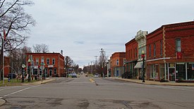
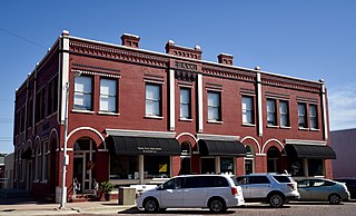
Litchfield is a city in Hillsdale County in the U.S. state of Michigan. The population was 1,399 at the 2020 census.
The city is surrounded by Litchfield Township, but the two are administered autonomously.
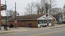
The area was first settled by Henry Stevens in 1834. It was platted in 1836 by Hervey Smith and his son David, and the community was named Smithsville. Hervey became the first postmaster when the post office opened on February 3, 1837. The post office was named Columbus, and it was renamed to Litchfield on August 12, 1837. Stevens proposed the name after Litchfield, Connecticut, where many of the early settlers originated. Litchfield incorporated as a village in 1877. [4] The village was part of Litchfield Township until it incorporated as a city in 1970. [5]
According to the U.S. Census Bureau, the city has a total area of 2.81 square miles (7.28 km2), of which 2.78 square miles (7.20 km2) is land and 0.04 square miles (0.10 km2) (1.42%) is water. [1]
The St. Joseph River flows through the city. The North Country Trail also runs through the center of the city. [5]
Census | Pop. | Note | %± |
---|---|---|---|
1880 | 1,029 | — | |
1890 | 601 | −41.6% | |
1900 | 645 | 7.3% | |
1910 | 660 | 2.3% | |
1920 | 716 | 8.5% | |
1930 | 634 | −11.5% | |
1940 | 717 | 13.1% | |
1950 | 882 | 23.0% | |
1960 | 993 | 12.6% | |
1970 | 1,167 | 17.5% | |
1980 | 1,353 | 15.9% | |
1990 | 1,317 | −2.7% | |
2000 | 1,458 | 10.7% | |
2010 | 1,369 | −6.1% | |
2020 | 1,399 | 2.2% | |
U.S. Decennial Census [6] |
As of the census [7] of 2010, there were 1,369 people, 559 households, and 365 families living in the city. The population density was 547.6 inhabitants per square mile (211.4/km2). There were 616 housing units at an average density of 246.4 per square mile (95.1/km2). The racial makeup of the city was 96.9% White, 0.3% African American, 0.7% Native American, 0.1% Asian, 1.1% from other races, and 0.9% from two or more races. Hispanic or Latino of any race were 2.9% of the population.
There were 559 households, of which 32.7% had children under the age of 18 living with them, 45.6% were married couples living together, 12.2% had a female householder with no husband present, 7.5% had a male householder with no wife present, and 34.7% were non-families. 29.2% of all households were made up of individuals, and 12.3% had someone living alone who was 65 years of age or older. The average household size was 2.44 and the average family size was 2.99.
The median age in the city was 38.4 years. 25.6% of residents were under the age of 18; 9% were between the ages of 18 and 24; 23.4% were from 25 to 44; 27% were from 45 to 64; and 15% were 65 years of age or older. The gender makeup of the city was 49.8% male and 50.2% female.
As of the census [2] of 2000, there were 1,458 people, 568 households, and 362 families living in the city. The population density was 608.9 inhabitants per square mile (235.1/km2). There were 604 housing units at an average density of 252.2 per square mile (97.4/km2). The racial makeup of the city was 98.42% White, 0.21% African American, 0.07% Asian, 0.62% from other races, and 0.69% from two or more races. Hispanic or Latino of any race were 1.99% of the population.
There were 568 households, out of which 34.2% had children under the age of 18 living with them, 47.7% were married couples living together, 11.4% had a female householder with no husband present, and 36.1% were non-families. 31.9% of all households were made up of individuals, and 15.1% had someone living alone who was 65 years of age or older. The average household size was 2.40 and the average family size was 3.04.
In the city, the population was spread out, with 26.3% under the age of 18, 9.3% from 18 to 24, 26.2% from 25 to 44, 20.3% from 45 to 64, and 17.8% who were 65 years of age or older. The median age was 37 years. For every 100 females, there were 87.6 males. For every 100 females age 18 and over, there were 85.8 males.
The median income for a household in the city was $39,292, and the median income for a family was $47,500. Males had a median income of $34,464 versus $24,671 for females. The per capita income for the city was $17,362. About 5.6% of families and 10.3% of the population were below the poverty line, including 7.2% of those under age 18 and 17.9% of those age 65 or over.
The city is served entirely by its own school district, Litchfield Community Schools, which also serves portions of several adjacent townships. [8]
Woodbine is a city in Harrison County, Iowa, United States, along the Boyer River. The population was 1,625 at the time of the 2020 census.
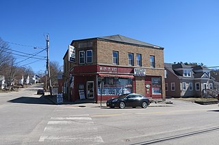
Sabattus is a town in Androscoggin County, Maine, United States. The population was 5,044 at the 2020 census. It is included in both the Lewiston-Auburn, Maine Metropolitan Statistical Area and the Lewiston-Auburn, Maine Metropolitan New England City and Town Area. The town was formerly known as "Webster", and changed its name to "Sabattus" in 1971, in honor of a former Anasagunticook Indian chief. The village of Sabattus is in the northwestern corner of the town, at the outlet of Sabattus Pond.
Wales is a town in Androscoggin County, Maine, United States. The population was 1,608 at the 2020 census. It is included in both the Lewiston-Auburn, Maine Metropolitan Statistical Area and the Lewiston-Auburn, Maine Metropolitan New England City and Town Area.
Litchfield is a town in Kennebec County, Maine, United States. The population was 3,586 at the 2020 census. Litchfield is included in the Augusta, Maine micropolitan and included in the Lewiston-Auburn, Maine metropolitan New England city and town area. Litchfield is included Wales, Maine micropolitan
Coloma is a city in Berrien County in the U.S. state of Michigan. The population was 1,465 at the 2020 census.
Olivet is a city in Eaton County in the U.S. state of Michigan. The population was 1,605 at the 2010 census. University Of Olivet is located in the city.
Gladwin is a city in Gladwin County in the U.S. state of Michigan. The population was 3,069 at the 2020 census. Gladwin is the county seat of Gladwin County. The city is at the southwest corner of Gladwin Township, but the two are administered autonomously.
Allen Township is a civil township of Hillsdale County in the U.S. state of Michigan. The population was 1,334 at the 2020 census.
Litchfield Township is a civil township of Hillsdale County in the U.S. state of Michigan. The population was 1,029 at the 2020 census.
Scipio Township is a civil township of Hillsdale County in the U.S. state of Michigan. The population was 1,902 at the 2020 census.
Petersburg is a city in Monroe County in the U.S. state of Michigan. The population was 1,171 at the 2020 census.
North Muskegon is a city in Muskegon County in the U.S. state of Michigan. The population was 4,093 at the 2020 census, up from 3,786 in 2010.
Roosevelt Park is a city in Muskegon County in the U.S. state of Michigan. The population was 4,172 at the 2020 census, up from 3,831 in 2010.
Ferrysburg is a city in Ottawa County in the U.S. state of Michigan. The population was 2,892 at the 2010 census.
Perry is a city in Shiawassee County in the U.S. state of Michigan. The population was 2,188 at the 2010 census. The city is surrounded by Perry Township, but the two are administered autonomously.
Hartford is a city in Van Buren County in the U.S. state of Michigan. The population was 2,688 at the 2010 census. The city is located within Hartford Township, but is politically independent.
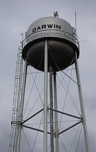
Darwin is a city in Meeker County, Minnesota, United States. The population was 348 at the 2020 census.
Darwin Township is a township in Meeker County, Minnesota, United States. The population was 713 at the 2000 census. The township includes the city of Darwin plus a small eastern portion of the city of Litchfield.
Litchfield Township is a township in Meeker County, Minnesota, United States. The population was 808 at the 2000 census. The township includes most of the city of Litchfield, except for a small protrusion northeast into Forest City Township and another small one due east into Darwin Township.
Eden Valley is a city in Meeker and Stearns counties in the U.S. state of Minnesota. The population was 1,027 at the 2020 census. Most of Eden Valley is in Meeker County; the Stearns County portion is part of the St. Cloud Metropolitan Statistical Area.