Jonesville, Michigan

Last updated
Jonesville, Michigan
City of Jonesville
Jonesville, Michigan (2022).jpg
Looking southwest along U.S. Route 12
Jonesville, MI location.png
Location within Hillsdale County
USA Michigan location map.svg
Red pog.svg
Jonesville
Location within the state of Michigan
Usa edcp location map.svg
Red pog.svg
Jonesville
Location within the United States
Coordinates: 41°58′52″N84°39′59″W / 41.98111°N 84.66639°W / 41.98111; -84.66639
CountryUnited States
State Michigan
County Hillsdale
Founded1828
Incorporated1855 (village)
2014 (city)
Government
  Type Council–manager
   Mayor Gerald Arno
   Clerk Cindy Means
   Manager Jeffrey Gray
Area
[1]
  Total2.83 sq mi (7.33 km2)
  Land2.79 sq mi (7.23 km2)
  Water0.03 sq mi (0.10 km2)
Elevation
1,076 ft (328 m)
Population
 (2020)
  Total2,176
  Density887.46/sq mi (342.65/km2)
Time zone UTC-5 (Eastern (EST))
  Summer (DST) UTC-4 (EDT)
ZIP code(s)
49250
Area code 517
FIPS code 26-41920 [2]
GNIS feature ID0629385 [3]
Website Official website

Jonesville is a city in Hillsdale County in the U.S. state of Michigan. The population was 2,176 at the 2020 census.

Contents

History

The area was first settled by brothers Benaiah and Edmund Jones, who came here from Painesville, Ohio in 1828 and purchased land the next year. They surveyed and platted the community by 1831. It served as the first county seat of Hillsdale County, which was formally organized in 1835. The Jonesville post office opened on January 21, 1841. The community incorporated as a village in 1855. Jonesville once contained a railway station along the Lake Shore and Michigan Southern Railway. [4]

In August 2014, the village voted to adopt a charter and incorporated as a city. [5]

The city contains three listings on the National Register of Historic Places: J.J. Deal and Son Carriage Factory, Grace Episcopal Church, and the E.O. Grosvenor House. All three of these are also Michigan State Historic Sites, and the city also includes the state historic sites the Delevan (Munro) House and Kiddie Brush and Toy Company. The toy company occupied the same building as the Carriage Factory, which is now renovated as an apartment complex.

Geography

According to the U.S. Census Bureau, the village has a total area of 2.83 square miles (7.33 km2), of which 2.79 square miles (7.23 km2) is land and 0.04 square miles (0.10 km2) (0.99%) is water. [1]

The St. Joseph River flows through the city.

Major highways

Demographics

Historical population
CensusPop.Note
1850 565
1860 1,00878.4%
1880 1,445
1890 1,288−10.9%
1900 1,3071.5%
1910 1,3966.8%
1920 1,274−8.7%
1930 1,3163.3%
1940 1,302−1.1%
1950 1,59422.4%
1960 1,89618.9%
1970 2,0819.8%
1980 2,1724.4%
1990 2,2835.1%
2000 2,3372.4%
2010 2,258−3.4%
2020 2,176−3.6%
U.S. Decennial Census [6]

2010 census

As of the census [7] of 2010, there were 2,258 people, 894 households, and 596 families living in the village. The population density was 781.3 inhabitants per square mile (301.7/km2). There were 983 housing units at an average density of 340.1 per square mile (131.3/km2). The racial makeup of the village was 95.3% White, 2.1% African American, 0.3% Native American, 0.9% Asian, 0.3% from other races, and 1.1% from two or more races. Hispanic or Latino of any race were 2.1% of the population.

There were 894 households, of which 30.1% had children under the age of 18 living with them, 48.2% were married couples living together, 13.4% had a female householder with no husband present, 5.0% had a male householder with no wife present, and 33.3% were non-families. 29.1% of all households were made up of individuals, and 14.8% had someone living alone who was 65 years of age or older. The average household size was 2.41 and the average family size was 2.95.

The median age in the village was 37.6 years. 26.3% of residents were under the age of 18; 9.2% were between the ages of 18 and 24; 23.3% were from 25 to 44; 23.8% were from 45 to 64; and 17.4% were 65 years of age or older. The gender makeup of the village was 47.4% male and 52.6% female.

2000 census

As of the census [2] of 2000, there were 2,337 people, 926 households, and 623 families living in the village. The population density was 856.7 inhabitants per square mile (330.8/km2). There were 975 housing units at an average density of 357.4 per square mile (138.0/km2). The racial makeup of the village was 96.02% White, 1.93% African American, 0.26% Native American, 0.21% Asian, 0.39% from other races, and 1.20% from two or more races. Hispanic or Latino of any race were 1.80% of the population.

There were 926 households, out of which 31.0% had children under the age of 18 living with them, 54.1% were married couples living together, 10.0% had a female householder with no husband present, and 32.7% were non-families. 28.9% of all households were made up of individuals, and 13.2% had someone living alone who was 65 years of age or older. The average household size was 2.39 and the average family size was 2.92.

In the village, the population was spread out, with 27.9% under the age of 18, 8.0% from 18 to 24, 26.4% from 25 to 44, 22.4% from 45 to 64, and 15.2% who were 65 years of age or older. The median age was 36 years. For every 100 females, there were 102.0 males. For every 100 females age 18 and over, there were 93.8 males.

The median income for a household in the village was $35,223, and the median income for a family was $41,813. Males had a median income of $34,135 versus $23,333 for females. The per capita income for the village was $15,877. About 6.5% of families and 9.9% of the population were below the poverty line, including 9.5% of those under age 18 and 5.8% of those age 65 or over.

Education

The city is served entirely by its own school district, Jonesville Community Schools, which also serves large areas of several neighboring townships. [8]

Images

Related Research Articles

<span class="mw-page-title-main">Hillsdale, Illinois</span> Village in Illinois, United States

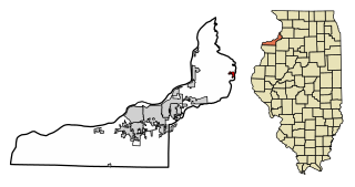
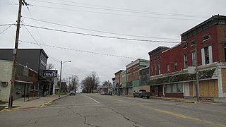
Hillsdale is a village in Rock Island County, Illinois, United States. The population was 523 at the 2010 census.

<span class="mw-page-title-main">Adams Township, Hillsdale County, Michigan</span> Civil township in Michigan, United States

Adams Township is a civil township of Hillsdale County in the U.S. state of Michigan. The population was 2,262 at the 2020 census.

<span class="mw-page-title-main">Allen, Michigan</span> Village in Michigan, United States

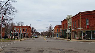
Allen is a village in Hillsdale County in the U.S. state of Michigan. The population was 201 at the 2020 census.

<span class="mw-page-title-main">Allen Township, Michigan</span> Civil township in Michigan, United States

Allen Township is a civil township of Hillsdale County in the U.S. state of Michigan. The population was 1,334 at the 2020 census.

<span class="mw-page-title-main">Camden, Michigan</span> Village in Michigan, United States

Camden is a village in Hillsdale County in the U.S. state of Michigan. The population was 496 at the 2020 census. The village is located within Camden Township.

<span class="mw-page-title-main">Camden Township, Michigan</span> Civil township in Michigan, United States

Camden Township is a civil township of Hillsdale County in the U.S. state of Michigan. The population was 2,093 at the 2020 census. The villages of Camden and Montgomery are within the township.

<span class="mw-page-title-main">Fayette Township, Michigan</span> Civil township in Michigan, United States

Fayette Township is a civil township of Hillsdale County in the U.S. state of Michigan. The population was 990 at the 2020 census, which ranks it the least-populated township in the county. This is a significant decrease from 3,326 at the 2010 census, which was due to the village of Jonesville incorporating as an autonomous city in 2014.

<span class="mw-page-title-main">Hillsdale, Michigan</span> City in Michigan, United States

Hillsdale is the largest city and county seat of Hillsdale County in the U.S. state of Michigan. The population was 8,036 at the 2020 census. The city is the home of Hillsdale College, a private liberal arts college.

<span class="mw-page-title-main">Hillsdale Township, Michigan</span> Civil township in Michigan, United States

Hillsdale Township is a civil township of Hillsdale County in the U.S. state of Michigan. The population was 2,133 at the 2020 census.

<span class="mw-page-title-main">Litchfield, Michigan</span> City in Michigan, United States

Litchfield is a city in Hillsdale County in the U.S. state of Michigan. The population was 1,399 at the 2020 census.

<span class="mw-page-title-main">Litchfield Township, Michigan</span> Civil township in Michigan, United States

Litchfield Township is a civil township of Hillsdale County in the U.S. state of Michigan. The population was 1,029 at the 2020 census.

<span class="mw-page-title-main">Montgomery, Michigan</span> Village in Michigan, United States

Montgomery is a village in Hillsdale County in the U.S. state of Michigan. The population was 322 at the 2020 census. The village is located within Camden Township.

<span class="mw-page-title-main">Moscow Township, Michigan</span> Civil township in Michigan, United States

Moscow Township is a civil township of Hillsdale County in the U.S. state of Michigan. The population was 1,467 at the 2020 census.

<span class="mw-page-title-main">North Adams, Michigan</span> Village in Michigan, United States

North Adams is a village in Hillsdale County in the U.S. state of Michigan. The population was 452 at the 2020 census. The village is located within Adams Township.

<span class="mw-page-title-main">Reading, Michigan</span> City in Michigan, United States

Reading is a city in Hillsdale County in the U.S. state of Michigan. The population was 1,095 at the 2020 census.

<span class="mw-page-title-main">Reading Township, Michigan</span> Civil township in Michigan, United States

Reading Township is a civil township of Hillsdale County in the U.S. state of Michigan. The population was 1,910 at the 2020 census.

<span class="mw-page-title-main">Scipio Township, Michigan</span> Civil township in Michigan, United States

Scipio Township is a civil township of Hillsdale County in the U.S. state of Michigan. The population was 1,902 at the 2020 census.

<span class="mw-page-title-main">Waldron, Michigan</span> Village in Michigan, United States

Waldron is a village in Hillsdale County in the U.S. state of Michigan. The population was 505 at the 2020 census. The village is located within Wright Township.

<span class="mw-page-title-main">Hanover Township, Jackson County, Michigan</span> Civil township in Michigan, United States

Hanover Township is a civil township of Jackson County in the U.S. state of Michigan. The population was 3,695 at the 2010 census.

<span class="mw-page-title-main">Hillsdale, Missouri</span> Village in Missouri, United States

Hillsdale is a village in St. Louis County, Missouri, United States. Hillsdale consists of 67th, 68th, 69th, St.Louis Ave and sometimes Rosebud. Hillsdale is also home of Greenwood Cemetery. The population was 1,478 at the 2010 census.

References

  1. 1 2 "2020 U.S. Gazetteer Files". United States Census Bureau. Retrieved May 21, 2022.
  2. 1 2 "U.S. Census website". United States Census Bureau . Retrieved 2008-01-31.
  3. U.S. Geological Survey Geographic Names Information System: Jonesville, Michigan
  4. Romig, Walter (October 1, 1986) [1973]. Michigan Place Names: The History of the Founding and the Naming of More Than Five Thousand Past and Present Michigan Communities (Paperback). Detroit, Michigan: Wayne State University Press. p. 295. ISBN   978-0-8143-1838-6.
  5. Maneval, Matthew (7 August 2014). "City Charter approved by voters". Hillsdale Daily News. Archived from the original on 6 July 2015. Retrieved 2 December 2014.
  6. "Census of Population and Housing". Census.gov. Retrieved June 4, 2015.
  7. "U.S. Census website". United States Census Bureau . Retrieved 2012-11-25.
  8. Michigan Geographic Framework (15 November 2013). "Hillsdale County School Districts" (PDF). Retrieved December 13, 2022.