Allen, Michigan

Last updated

Allen, Michigan
Village of Allen
Allen, Michigan (2022).jpg
Looking east along W. Chicago Road (US 12)
Nickname: 
"Antique Capital of Michigan" [1]
Allen, MI location.png
Location within Hillsdale County
USA Michigan location map.svg
Red pog.svg
Allen
Location within the state of Michigan
Usa edcp location map.svg
Red pog.svg
Allen
Location within the United States
Coordinates: 41°57′29″N84°46′05″W / 41.95806°N 84.76806°W / 41.95806; -84.76806
CountryUnited States
State Michigan
County Hillsdale
Township Allen
Settled1827
Platted 1868
Incorporated1950
Government
[2]
  Type Village council
  PresidentPaul Seegert
   Clerk Melani Matthews
Area
[3]
  Total0.174 sq mi (0.451 km2)
  Land0.174 sq mi (0.451 km2)
  Water0.00 sq mi (0.00 km2)
Elevation
1,076 ft (328 m)
Population
 (2020)
  Total201
  Density1,155.17/sq mi (446.62/km2)
Time zone UTC-5 (Eastern (EST))
  Summer (DST) UTC-4 (EDT)
ZIP code(s)
49227
Area code 517
FIPS code 26-01300 [4]
GNIS feature ID2397933 [5]

Allen is a village in Hillsdale County in the U.S. state of Michigan. The population was 201 at the 2020 census.

Contents

The village is within Allen Township at the junction of U.S. Route 12 and M-49. With a total land area of only 0.174 square miles (0.451 km2), Allen is the fourth smallest village by land area in the state of Michigan and the fifth smallest municipality overall after Ahmeek, Copper City, Novi Township, and Eagle.

History

The community was first settled by War of 1812 veteran Captain Moses Allen and his family in 1827. A post office under the name Sylvanus opened on July 13, 1830. It closed briefly from September 5, 1834, to September 9, 1835. The name of the office was changed to Allen in honor of Moses Allen on August 17, 1868. The community was thriving and was platted that same year, and Allen received a railway depot along the Lake Shore and Michigan Southern Railway. In 1950, Allen incorporated as a village. [6]

Geography

According to the U.S. Census Bureau, the village has a total area of 0.174 square miles (0.451 km2), all land. [3]

Major highways

Demographics

Historical population
CensusPop.Note
1960 325
1970 38518.5%
1980 266−30.9%
1990 201−24.4%
2000 22511.9%
2010 191−15.1%
2020 2015.2%
U.S. Decennial Census [7]

2010 census

As of the census [8] of 2010, there were 191 people, 80 households, and 51 families residing in the village. The population density was 1,193.8 inhabitants per square mile (460.9/km2). There were 94 housing units at an average density of 587.5 per square mile (226.8/km2). The racial makeup of the village was 97.9% White, 1.0% Asian, and 1.0% from two or more races.

There were 80 households, of which 23.8% had children under the age of 18 living with them, 56.3% were married couples living together, 6.3% had a female householder with no husband present, 1.3% had a male householder with no wife present, and 36.3% were non-families. 25.0% of all households were made up of individuals, and 18.8% had someone living alone who was 65 years of age or older. The average household size was 2.39 and the average family size was 2.94.

The median age in the village was 45.8 years. 19.4% of residents were under the age of 18; 7.8% were between the ages of 18 and 24; 22.1% were from 25 to 44; 26.7% were from 45 to 64; and 24.1% were 65 years of age or older. The gender makeup of the village was 49.7% male and 50.3% female.

2000 census

As of the census [4] of 2000, there were 225 people, 87 households, and 58 families residing in the village. The population density was 1,470.7 inhabitants per square mile (567.8/km2). There were 93 housing units at an average density of 607.9 per square mile (234.7/km2). The racial makeup of the village was 98.67% White, and 1.33% from two or more races.

There were 87 households, out of which 32.2% had children under the age of 18 living with them, 57.5% were married couples living together, 5.7% had a female householder with no husband present, and 32.2% were non-families. 28.7% of all households were made up of individuals, and 16.1% had someone living alone who was 65 years of age or older. The average household size was 2.59 and the average family size was 3.22.

In the village, the population was spread out, with 27.6% under the age of 18, 7.1% from 18 to 24, 27.1% from 25 to 44, 21.3% from 45 to 64, and 16.9% who were 65 years of age or older. The median age was 38 years. For every 100 females, there were 95.7 males. For every 100 females age 18 and over, there were 87.4 males.

The median income for a household in the village was $42,344, and the median income for a family was $45,417. Males had a median income of $30,250 versus $21,111 for females. The per capita income for the village was $14,251. About 8.0% of families and 5.5% of the population were below the poverty line, including none of those under the age of eighteen or sixty five or over.

Education

The village is served entirely by the Quincy Community School District to the west in the village of Quincy in Branch County. [9]

Notable people

Images

Related Research Articles

<span class="mw-page-title-main">Freeport, Michigan</span> Village in Michigan, United States

Freeport is a village in Barry County in the U.S. state of Michigan. The population was 542 at the 2020 census. The village is mostly within Irving Township, though a small portion lies in Carlton Township.

<span class="mw-page-title-main">Quincy, Michigan</span> Village in Michigan, United States

Quincy is a village in Branch County in the U.S. state of Michigan. The population was 1,554 at the 2020 census. The village is centered along U.S. Route 12 within Quincy Township.

<span class="mw-page-title-main">Athens, Michigan</span> Village in Michigan, United States

Athens is a village in Calhoun County in the U.S. state of Michigan. The population was 936 at the 2020 census. The village is located in southern Athens Township, and is part of the Battle Creek, Michigan Metropolitan Statistical Area. It was settled in 1831.

<span class="mw-page-title-main">Burlington, Michigan</span> Village in Michigan, United States

Burlington is a village in Calhoun County in the U.S. state of Michigan. The population was 281 at the 2020 census. It is part of the Battle Creek, Michigan Metropolitan Statistical Area. The village is located within Burlington Township on M-60.

<span class="mw-page-title-main">Tekonsha, Michigan</span> Village in Michigan, United States

Tekonsha is a village in Tekonsha Township, Calhoun County in the U.S. state of Michigan. It is part of the Battle Creek, Michigan Metropolitan Statistical Area. The population was 653 at the 2020 census.

<span class="mw-page-title-main">Ashley, Michigan</span> Village in Michigan, United States

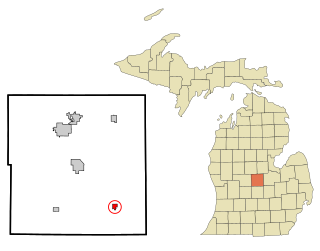
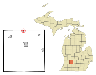
Ashley is a village in Gratiot County in the U.S. state of Michigan. The population was 508 at the 2020 census. The village is located in the northwest corner of Elba Township. No major state trunkline runs through the village, although M-57 passes within one mile to the south. Ashley was platted in 1884.

<span class="mw-page-title-main">Allen Township, Michigan</span> Civil township in Michigan, United States

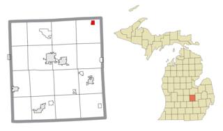
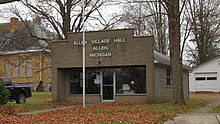
Allen Township is a civil township of Hillsdale County in the U.S. state of Michigan. The population was 1,334 at the 2020 census.

<span class="mw-page-title-main">Elkton, Michigan</span> Village in Michigan, United States

Elkton is a village in Huron County in the U.S. state of Michigan. The population was 796 at the 2020 census. The village is within Oliver Township, along the Pinnebog River. It was incorporated in 1897.

<span class="mw-page-title-main">Kinde, Michigan</span> Village in Michigan, United States

Kinde is a village in Huron County in the U.S. state of Michigan. The population was 448 at the 2010 census.

<span class="mw-page-title-main">Port Austin, Michigan</span> Village in Michigan, United States

Port Austin is a village in Huron County in the U.S. state of Michigan. The population was 664 at the 2010 census. The village is within Port Austin Township.

<span class="mw-page-title-main">Stockbridge, Michigan</span> Village in Michigan, United States

Stockbridge is a village in Ingham County in the U.S. state of Michigan. It is located within Stockbridge Township about 36 miles (58 km) southeast from downtown Lansing. The population was 1,218 at the 2010 census.

<span class="mw-page-title-main">Lyons, Michigan</span> Village in Michigan, United States

Lyons is a village in Ionia County in the U.S. state of Michigan. The population was 789 at the 2010 census. Most of the village is within Lyons Township. A small portion extends west into Ionia Township.

<span class="mw-page-title-main">Muir, Michigan</span> Village in Michigan, United States

Muir is a village in Lyons Township, Ionia County in the U.S. state of Michigan. The population was 604 at the 2010 census.

<span class="mw-page-title-main">Clinton, Lenawee County, Michigan</span> Village in Michigan, United States

Clinton is a village in Lenawee County in the Irish Hills area of the U.S. state of Michigan. The population was 2,336 at the 2010 census. The village is located within Clinton Township.

<span class="mw-page-title-main">Spring Lake, Michigan</span> Village in Michigan, United States

Spring Lake is a village in Ottawa County in the U.S. state of Michigan. The population was 2,497 at the 2020 census. The village is located within Spring Lake Township; the two share a ZIP code.

<span class="mw-page-title-main">Applegate, Michigan</span> Village in Michigan, United States

Applegate is a village in Sanilac County of the U.S. state of Michigan. The population was 241 at the 2020 census. Applegate is in the southeast corner of Washington Township on the boundary with Sanilac Township.

<span class="mw-page-title-main">New Lothrop, Michigan</span> Village in Michigan, United States

New Lothrop is a village in Shiawassee County in the U.S. state of Michigan. The population was 565 at the 2020 census. The village is located within Hazelton Township.

<span class="mw-page-title-main">Breedsville, Michigan</span> Village in Michigan, United States

Breedsville is a village in Van Buren County of the U.S. state of Michigan. The population was 199 at the 2010 census. The village is within Columbia Township.

<span class="mw-page-title-main">Lawton, Michigan</span> Village in Michigan, United States

Lawton is a village in southeastern Van Buren County, Michigan, United States. The population was 1,900 at the 2010 census.

<span class="mw-page-title-main">Otter Lake, Michigan</span> Village in Michigan, United States

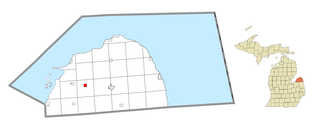
Otter Lake is a village in the U.S. state of Michigan. The village is split between Marathon Township in Lapeer County to the east and Forest Township in Genesee County to the west. The population was 426 at the 2020 census.

References

  1. Michigan Economic Development Corporation (2020). "Pure Michigan CITY > ALLEN" . Retrieved March 27, 2020.
  2. Village of Allen (June 7, 2021). "Village of Allen: Regular Meeting Agenda" . Retrieved December 16, 2022.
  3. 1 2 "2020 U.S. Gazetteer Files". United States Census Bureau. Retrieved May 21, 2022.
  4. 1 2 "U.S. Census website". United States Census Bureau . Retrieved January 31, 2008.
  5. U.S. Geological Survey Geographic Names Information System: Allen, Michigan
  6. Romig, Walter (October 1, 1986) [1973]. Michigan Place Names: The History of the Founding and the Naming of More Than Five Thousand Past and Present Michigan Communities (Paperback). Detroit, Michigan: Wayne State University Press. pp. 17–18. ISBN   978-0-8143-1838-6.
  7. "Census of Population and Housing". Census.gov. Retrieved June 4, 2015.
  8. "U.S. Census website". United States Census Bureau . Retrieved November 25, 2012.
  9. Michigan Geographic Framework (November 15, 2013). "Hillsdale County School Districts" (PDF). Retrieved December 11, 2022.
  10. Baseball-Reference.com (2022). "Baseball-Reference: Ed Donnelly" . Retrieved December 12, 2022.
  11. Joy, Alfred H. (December 1935). "Charles Edward St. John". Popular Astronomy. 61 (10): 611. Bibcode:1935PA.....43..611J . Retrieved December 12, 2022.