Related Research Articles

Northwest Alabama Regional Airport is a public-use airport located one mile east of Muscle Shoals, in Colbert County, Alabama. It is owned by the counties of Colbert and Lauderdale. The airport is serviced by Contour Airlines, subsidized by the Essential Air Service program. Formerly, the airport operated as Muscle Shoals Auxiliary Field.

Gulf Shores International Airport/Jack Edwards Field is a public use airport in Baldwin County, Alabama, United States. It is owned by Gulf Shores Airport Authority and located two nautical miles (4 km) north of the City of Gulf Shores. Also was known as Jack Edwards National Airport, it is included in the National Plan of Integrated Airport Systems for 2011–2015, which categorized it as a general aviation facility.

Northeast Alabama Regional Airport is five miles southwest of Gadsden, in Etowah County, Alabama. It is owned by Gadsden Airport Authority and it used to be Gadsden Municipal Airport. The FAA's National Plan of Integrated Airport Systems for 2009–2013 categorized as a general aviation facility.

Roanoke Municipal Airport is two miles south of Roanoke, in Randolph County, Alabama. The FAA's National Plan of Integrated Airport Systems for 2009–2013 categorized it as a general aviation facility.

Wetumpka Municipal Airport is a city-owned, public-use airport located six nautical miles west of the central business district of Wetumpka, a city in Elmore County, Alabama, United States. It is included in the FAA's National Plan of Integrated Airport Systems for 2011–2015, which categorized it as a general aviation facility. During World War II the airport, known then as Elmore Auxiliary Field, served as an auxiliary field for Gunter Army Airfield training operations. In 2013 the airport was listed in the Alabama Register of Landmarks and Heritage.

Camden Municipal Airport is a city-owned, public-use airport located three nautical miles (6 km) southwest of the central business district of Camden, a city in Wilcox County, Alabama, United States.

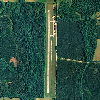
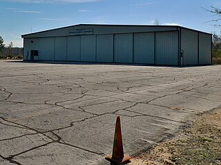
Isbell Field is a city-owned public-use airport located two nautical miles north of the central business district of Fort Payne, a city in DeKalb County, Alabama, United States. According to the FAA's National Plan of Integrated Airport Systems for 2009–2013, it is categorized as a general aviation facility.

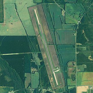
Geneva Municipal Airport is a city-owned public-use airport located two nautical miles north of the central business district of Geneva, a city in Geneva County, Alabama, United States. According to the FAA's National Plan of Integrated Airport Systems for 2009–2013, it is categorized as a general aviation facility.
Greensboro Municipal Airport is a city-owned public-use airport located three nautical miles southwest of the central business district of Greensboro, a city in Hale County, Alabama, United States.

Headland Municipal Airport is a city-owned, public-use airport located two nautical miles northeast of the central business district of Headland, a city in Henry County, Alabama, United States.
Jackson Municipal Airport is a city-owned public airport two miles south of Jackson, in Clarke County, Alabama.
Vaiden Field Airport is a public-use airport located eight nautical miles southwest of the central business district of Marion, in the community of Vaiden, Perry County, Alabama, United States. It is owned by the Perry County Airport and Industrial Authority.
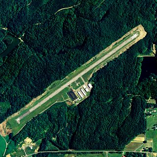
Robbins Field is a public use airport located five nautical miles northeast of the central business district of Oneonta, a city in Blount County, Alabama, United States. It is owned by the City of Oneonta and Blount County. According to the FAA's National Plan of Integrated Airport Systems for 2009–2013, it is categorized as a general aviation facility.

Scottsboro Municipal Airport, also known as Word Field, is a city-owned public-use airport located two nautical miles (3.7 km) northeast of the central business district of Scottsboro, a city in Jackson County, Alabama, United States. According to the FAA's National Plan of Integrated Airport Systems for 2009–2013, it is categorized as a general aviation facility.

Ardmore Airport is a privately owned airport, located two nautical miles southwest of the central business district of Ardmore, a city in Limestone County, Alabama, United States. The airport is currently unlicensed by the State of Alabama.

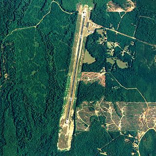
Moontown Airport is a privately owned public-use airport located seven nautical miles east of the central business district of Huntsville, a city in Madison County, Alabama, United States. It is 16 miles (26 km) east of Huntsville International Airport (HSV).
Frank Sikes Airport is a city-owned public-use airport located two nautical miles north of the central business district of Luverne, a city in Crenshaw County, Alabama, United States.
McMinn Airport is a privately owned public-use airport located one nautical mile southwest of the central business district of Weaver, a city in Calhoun County, Alabama, United States.
Stevenson Airport is a city-owned public-use airport located two nautical miles southwest of the central business district of Stevenson, a city in Jackson County, Alabama, United States.
Eutaw Municipal Airport is a city-owned, public-use airport located two nautical miles southeast of the central business district of Eutaw, a city in Greene County, Alabama, United States. As of 8 December 2017, the airport is indefinitely closed.
References
- 1 2 3 "L44 - Moundville Airport - FAA information effective 22 Oct 2009". FAA data republished by AirNav. Archived from the original on 24 November 2009.