Bessemer Airport is a city-owned public-use airport located three nautical miles southeast of the central business district of Bessemer, a city in Jefferson County, Alabama, United States. According to the FAA's National Plan of Integrated Airport Systems for 2009–2013, it is categorized as a reliever airport for the Birmingham-Shuttlesworth International Airport.

Moton Field Municipal Airport is a public-use airport located three nautical miles north of the central business district of Tuskegee, a city in Macon County, Alabama, United States. The airport is owned by the City of Tuskegee. It is included in the FAA's National Plan of Integrated Airport Systems for 2011–2015, which categorized it as a general aviation facility.

Wetumpka Municipal Airport is a city-owned, public-use airport located six nautical miles west of the central business district of Wetumpka, a city in Elmore County, Alabama, United States. It is included in the FAA's National Plan of Integrated Airport Systems for 2011–2015, which categorized it as a general aviation facility. During World War II the airport, known then as Elmore Auxiliary Field, served as an auxiliary field for Gunter Army Airfield training operations. In 2013 the airport was listed in the Alabama Register of Landmarks and Heritage.

Sylacauga Municipal Airport, also known as Merkel Field, is a city-owned public-use airport located three nautical miles west of the central business district of Sylacauga, a city in Talladega County, Alabama, United States. It is included in the FAA's National Plan of Integrated Airport Systems for 2011–2015, which categorized it as a general aviation facility.
St. Elmo Airport is a public-use airport located two nautical miles west of the central business district of St. Elmo, in Mobile County, Alabama, United States. It is included in the FAA's National Plan of Integrated Airport Systems for 2011–2015, which categorized it as a general aviation facility.
Carl Folsom Airport is a public-use airport located two nautical miles west of the central business district of Elba, a city in Coffee County, Alabama, United States. It is owned by the Elba Airport Authority.

Weedon Field is a city-owned, public-use airport located three nautical miles north of the central business district of Eufaula, a city in Barbour County, Alabama, United States.
Greensboro Municipal Airport is a city-owned public-use airport located three nautical miles southwest of the central business district of Greensboro, a city in Hale County, Alabama, United States.

Posey Field is a city-owned public-use airport located three nautical miles northeast of the central business district of Haleyville, a city in Winston County, Alabama, United States.

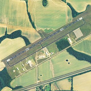
Hartselle–Morgan County Regional Airport is a public-use airport located two nautical miles south of the central business district of Hartselle, a city in Morgan County, Alabama, United States. The airport was formerly known as Rountree Field, named in the 1960s for Asa Rountree Sr., a former head of the Alabama Department of Aeronautics.

Headland Municipal Airport is a city-owned, public-use airport located two nautical miles northeast of the central business district of Headland, a city in Henry County, Alabama, United States.

Lanett Municipal Airport is a city-owned public-use airport located three nautical miles southwest of the central business district of Lanett, a city in Chambers County, Alabama, United States. According to the FAA's National Plan of Integrated Airport Systems for 2009–2013, it is categorized as a general aviation facility.

Blackwell Field is a public-use airport located two nautical miles southeast of the central business district of Ozark, in Dale County, Alabama, United States. The airport is owned by the Town of Ozark. It is included in the FAA's National Plan of Integrated Airport Systems for 2011–2015, which categorized it as a general aviation facility.

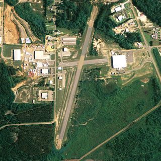
Russellville Municipal Airport, also known as Bill Pugh Field, is a city-owned public-use airport located three nautical miles southeast of the central business district of Russellville, a city in Franklin County, Alabama, United States. It is included in the FAA's National Plan of Integrated Airport Systems for 2011–2015, which categorized it as a general aviation facility.

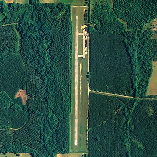
North Pickens Airport is a county-owned public-use airport in Pickens County, Alabama, United States. It is located one nautical mile north of the central business district of Reform, Alabama. The airport is included in the FAA's National Plan of Integrated Airport Systems for 2011–2015, which categorized it as a general aviation facility.

Prattville–Grouby Field is a public-use airport located three nautical miles southwest of the central business district of Prattville, a city in Autauga County, Alabama, United States. It is owned by the Prattville Airport Authority. It is also known as Prattville Airport or Autauga County Airport.

Ardmore Airport is a privately owned airport, located two nautical miles southwest of the central business district of Ardmore, a city in Limestone County, Alabama, United States. The airport is currently unlicensed by the State of Alabama.
Roy Wilcox Airport is a public use airport in Washington County, Alabama, United States. The airport is owned by the town of Chatom and located three nautical miles (6 km) east of its central business district.
Mark Reynolds/North Mobile County Airport is a privately owned public-use airport in Mobile County, Alabama, United States. It is located three nautical miles northeast of the central business district of Creola, Alabama.
Reeves Airport was a city-owned public-use airport located two nautical miles southeast of the central business district of Tallassee, a city in Tallapoosa County, Alabama, United States. The airport has been permanently closed.