
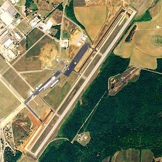
South Alabama Regional Airport at Bill Benton Field, formerly known as Andalusia-Opp Airport, is a public use airport in Covington County, Alabama, United States. It is located four nautical miles east of the central business district of Andalusia and about 9 miles (14 km) west of Opp. The airport is governed by the South Alabama Regional Airport Authority, with members appointed by the Andalusia City Council, the Opp Council, and the Covington County Commission.
Talladega Municipal Airport is a city-owned public-use airport located eight nautical miles northeast of the central business district of Talladega, a city in Talladega County, Alabama, adjacent to Talladega Superspeedway in the city of Lincoln. It is included in the FAA's National Plan of Integrated Airport Systems for 2011–2015, which categorized it as a general aviation facility.

Moton Field Municipal Airport is a public-use airport located three nautical miles north of the central business district of Tuskegee, a city in Macon County, Alabama, United States. The airport is owned by the City of Tuskegee. It is included in the FAA's National Plan of Integrated Airport Systems for 2011–2015, which categorized it as a general aviation facility.

Huntsville Executive Airport, also known as Tom Sharp Jr. Field and formerly Madison County Executive Airport, is a public-use airport in Madison County, Alabama, United States. It is owned by the Executive Flight Center and located eight nautical miles (14.80 km) northeast of the central business district of Huntsville. According to the FAA's National Plan of Integrated Airport Systems for 2009–2013, it is categorized as a general aviation facility.
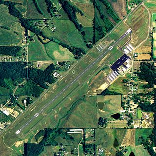
Albertville Regional Airport, also known as Thomas J. Brumlik Field, is a city-owned, public-use airport located three nautical miles southwest of the central business district of Albertville, in Marshall County, Alabama, United States. It was formerly known as Albertville Municipal Airport.

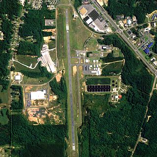
Craig Field is a public airport four miles southeast of Selma, in Dallas County, Alabama. The FAA's National Plan of Integrated Airport Systems for 2011–2015 categorized it as a general aviation facility. It was previously the U.S. Air Force Craig Air Force Base, closed in 1977.
Thomas C. Russell Field is a city-owned public-use airport located two nautical miles (4 km) southwest of the central business district of Alexander City, a city in Tallapoosa County, Alabama, United States.

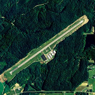
Camden Municipal Airport is a city-owned, public-use airport located three nautical miles (6 km) southwest of the central business district of Camden, a city in Wilcox County, Alabama, United States.

Chilton County Airport, also known as Gragg-Wade Field, is a public-use airport in Chilton County, Alabama, United States. It is located one nautical mile (2 km) east of the central business district of Clanton, Alabama. It is owned by the Chilton County Airport Authority.

Weedon Field is a city-owned, public-use airport located three nautical miles north of the central business district of Eufaula, a city in Barbour County, Alabama, United States.

Foley Municipal Airport is a city-owned public-use airport located three nautical miles northwest of the central business district of Foley, a city in Baldwin County, Alabama, United States.

Geneva Municipal Airport is a city-owned public-use airport located two nautical miles north of the central business district of Geneva, a city in Geneva County, Alabama, United States. According to the FAA's National Plan of Integrated Airport Systems for 2009–2013, it is categorized as a general aviation facility.

Grove Hill Municipal Airport was a city-owned public-use airport located two nautical miles southeast of the central business district of Grove Hill, a city in Clarke County, Alabama, United States. According to the FAA's National Plan of Integrated Airport Systems for 2009–2013, it was categorized as a general aviation facility. The airport has been permanently closed.
Guntersville Municipal Airport, also known as Joe Starnes Field, is a city-owned public-use airport located three nautical miles northeast of the central business district of Guntersville, a city in Marshall County, Alabama, United States. According to the FAA's National Plan of Integrated Airport Systems for 2009–2013, it is categorized as a general aviation facility.

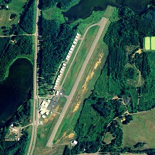
Posey Field is a city-owned public-use airport located three nautical miles northeast of the central business district of Haleyville, a city in Winston County, Alabama, United States.

Hartselle–Morgan County Regional Airport is a public-use airport located two nautical miles south of the central business district of Hartselle, a city in Morgan County, Alabama, United States. The airport was formerly known as Rountree Field, named in the 1960s for Asa Rountree Sr., a former head of the Alabama Department of Aeronautics.

Lanett Municipal Airport is a city-owned public-use airport located three nautical miles southwest of the central business district of Lanett, a city in Chambers County, Alabama, United States. According to the FAA's National Plan of Integrated Airport Systems for 2009–2013, it is categorized as a general aviation facility.
Robbins Field is a public use airport located five nautical miles northeast of the central business district of Oneonta, a city in Blount County, Alabama, United States. It is owned by the City of Oneonta and Blount County. According to the FAA's National Plan of Integrated Airport Systems for 2009–2013, it is categorized as a general aviation facility.

Blackwell Field is a public-use airport located two nautical miles southeast of the central business district of Ozark, in Dale County, Alabama, United States. The airport is owned by the Town of Ozark. It is included in the FAA's National Plan of Integrated Airport Systems for 2011–2015, which categorized it as a general aviation facility.

Scottsboro Municipal Airport, also known as Word Field, is a city-owned public-use airport located two nautical miles (3.7 km) northeast of the central business district of Scottsboro, a city in Jackson County, Alabama, United States. According to the FAA's National Plan of Integrated Airport Systems for 2009–2013, it is categorized as a general aviation facility.
