Dothan Regional Airport

Last updated
Dothan Regional Airport

(former Napier Army Airfield)
Dothan Regional Airport Logo.png
Dothan Regional Airport.jpg
NAIP image June 2006
Summary
Airport typePublic
OwnerDothan-Houston County Airport Authority
Serves Dothan, Alabama
Elevation  AMSL 401 ft / 122 m
Coordinates 31°19′16″N85°26′58″W / 31.32111°N 85.44944°W / 31.32111; -85.44944
Website FlyDothan.com
Maps
Airport diagram Dothan Regio 123.pdf
FAA diagram
USA Alabama relief location map.svg
Airplane silhouette.svg
DHN
Usa edcp relief location map.png
Airplane silhouette.svg
DHN
Runways
Direction LengthSurface
ftm
14/328,4992,590Asphalt
18/365,4981,676Asphalt
Statistics (2020)
Passengers47,990
Aircraft operations77,706
Based aircraft66

Dothan Regional Airport( IATA : DHN, ICAO : KDHN, FAA LID : DHN) is a public airport in Dale County, Alabama, United States, [2] seven miles northwest of Dothan, [3] a city mostly in Houston County. [2]

Contents

The National Plan of Integrated Airport Systems for 2011–2015 called it a primary commercial service airport (more than 10,000 enplanements per year). [4] Federal Aviation Administration records say the airport had 47,859 passenger boardings (enplanements) in calendar year 2008, [5] 42,071 in 2009 and 41,453 in 2010. [6]

The only commercial airline service is provided by twice-daily Delta Connection flights to Atlanta using CRJ-700 and CRJ-900 aircraft. Over 50% of Dothan's flights are military training operations from nearby Fort Novosel, NAS Whiting Field, and NAS Pensacola, while just under 40% are general aviation.

History

In 1941 the United States Army Air Corps built Napier Field, named in honor of Major Edward L. Napier of Union Springs, Alabama. One of the Army's first flight surgeons, he was killed in the crash of a Fokker D.VII, AS-5382, [7] at McCook Field, Dayton, Ohio, on 15 September 1923. He had been a Medical Corps Officer in World War I and had transferred to the Army Air Corps. He was receiving training as a flight surgeon at the time of his death. The official report states that he was piloting the plane himself and there was a structural failure of a wing. [8]

Napier Field was assigned to the Southeast Training Center of the Army Air Forces Training Command. It was commanded by the 73d Army Air Force Base Unit. In addition to the main facility, the following known sub-bases and auxiliaries were built to support the training operations:

The 29th Flying Training Wing was activated at Napier on December 26, 1942. The 2116th (Pilot School, Advanced, Single-Engine) was main operational group at Napier Field. The group flew mostly AT-6 Texans as well as providing advanced & specialized training in single engine aircraft, including P-40 fighters. The first aircraft began operating on the field on October 1, 1941.

On December 20, 1941, the first group of British cadets arrived for training under the Arnold Scheme. The first American cadets graduated on July 3, 1942 (42-F). In late May 1945, officers from the Mexican Army began P-40 training at Napier Field.

World War II Napier Field postcard Army Air Forces - Postcard - Napier Field Alabama.jpg
World War II Napier Field postcard

The field was inactivated by the U.S. Army Air Forces on October 31, 1945, and the airfield and its improvements were made available to the City of Dothan and Houston County under an Agreement in 1946 which was jointly accepted. The airport lands lay dormant for about 20 years and Houston County later turned its share of Napier Field to the city.

In the early 1960s, a complete overhaul of the facility commenced with the old USAAF airfield layout being largely dug up and converted into reinforced hard surface for new jet runways, buildings and other facilities for a civil airport. Dothan Regional Airport opened to commercial activity on February 15, 1965. [9] [10] [11] [12]

In 2004 the Air Force returned to the airport in the form of a non-flying unit, the 280th Combat Communications Squadron (280 CCS), an Air Force Special Operations Command (AFSOC)-gained unit of the Alabama Air National Guard, which established Dothan Regional Airport Air National Guard Station on the airport. [13]

Until 1965 the municipal airport was three miles west of town, where the Westgate Rec Center is now. It had three runways, all 4006 feet or less. Eastern Airlines stopped there from 1945 to 1964; Southern Airways arrived in 1956 and continued at the new airport.

Facilities

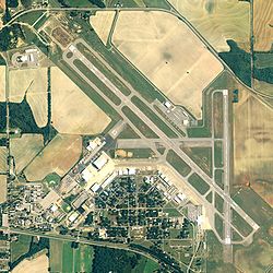
Dothan Regional Airport covers 1,150 acres (465 ha) at an elevation of 401 feet (122 m). It has two asphalt runways: 14/32 is 8,499 by 150 feet (2,590 x 46 m) and 18/36 is 5,498 by 100 feet (1,676 x 30 m). [2]

In 2011 the airport had 85,201 aircraft operations, an average of 233 per day: 55% military, 40% general aviation, 4% airline, and 1% air taxi. 91 aircraft were then based at this airport: 52% single-engine, 40% multi-engine, 8% jet, and 1% helicopter. [2]

Airline and destination

AirlinesDestinations
Delta Connection Atlanta [14]

Statistics

Top destinations

Busiest domestic routes from DHN (November 2021 - October 2022) [15]
RankAirportPassengersCarriers
1 Flag of Georgia (U.S. state).svg Atlanta, Georgia 40,000Delta

Annual enplanement

Annual enplanement at DHN [16]
YearEnplanementChange
199966,025
200069,220Increase2.svg4.8%
200155,064Decrease2.svg20.5%
200257,911Increase2.svg5.2%
200361,143Increase2.svg5.6%
200469,094Increase2.svg13.0%
200568,330Decrease2.svg1.1%
200657,552Decrease2.svg15.8%
200748,019Decrease2.svg16.6%
200847,859Decrease2.svg0.3%
200942,071Decrease2.svg12.1%
201041,453Decrease2.svg1.5%
201146,388Increase2.svg11.9%
201246,452Increase2.svg0.1%
201348,423Increase2.svg4.2%
201450,309Increase2.svg3.9%
201546,792Decrease2.svg7.0%
201649,411Increase2.svg5.6%
201747,304Decrease2.svg4.3%
201852,855Increase2.svg11.7%
201958,860Increase2.svg11.4%
202023,968Decrease2.svg59.3%

Incidents

In November 1985, a former US Air Force C-131H, AF Ser. No. 54-2817, which was in the process of being transferred from the Air Force to the US Navy's Fleet Air Logistics Squadron 48 (VR-48) at Andrews AFB/NAF Washington, Maryland, crashed on takeoff during a post-contract maintenance acceptance flight, killing the crew of 3 on board. Poor civilian contract maintenance on the elevator control cables was determined as the cause of the mishap. [17]

See also

Related Research Articles

<span class="mw-page-title-main">Gulfport–Biloxi International Airport</span> Airport in Gulfport, Mississippi

Gulfport–Biloxi International Airport is a joint civil–military public-use airport three nautical miles (6 km) northeast of the central business district of Gulfport, a city in Harrison County, Mississippi, United States. It is owned by the Gulfport–Biloxi Regional Airport Authority and serves the Gulf Coast area.

<span class="mw-page-title-main">Mobile Regional Airport</span> Airport in Mobile County, Alabama, US

Mobile Regional Airport is a public/military airport 13 miles (21 km) west of Mobile, in Mobile County, Alabama, United States. The airport is owned and operated by the Mobile Airport Authority, a self-funded entity that receives no local tax dollars.

<span class="mw-page-title-main">Merced Regional Airport</span> Municipal airport serving Merced, California, United States

Merced Regional Airport is located two miles (3.2 km) southwest of Merced, in Merced County, California. The National Plan of Integrated Airport Systems for 2021–2025 categorized it as a Commercial Service – Nonprimary airport. Commercial passenger service is subsidized by the Essential Air Service program.

<span class="mw-page-title-main">Western Nebraska Regional Airport</span> Airport in Scotts Bluff County, Nebraska

Western Nebraska Regional Airport is three miles east of Scottsbluff, in Scotts Bluff County, Nebraska. The airport is owned by the Airport Authority of Scotts Bluff County and is named after William B. Heilig. Known as "Scottsbluff's Mr. Aviation," he was a World War II United States Army Air Force primary flight instructor, a civil flight instructor, and manager of the city's airport.

<span class="mw-page-title-main">Alliance Municipal Airport</span> Airport

Alliance Municipal Airport is in Box Butte County, Nebraska, three miles southeast of the city of Alliance, which owns it. Denver Air Connection offers scheduled passenger flights to Denver, which are subsidized by the Essential Air Service program.

<span class="mw-page-title-main">Cavern City Air Terminal</span> Airport in Eddy County, New Mexico

Cavern City Air Terminal is a public use airport in Eddy County, New Mexico, United States. It is owned by the city of Carlsbad and located five nautical miles southwest of its central business district. The airport is served by one commercial airline, with scheduled passenger service subsidized by the Essential Air Service program.

<span class="mw-page-title-main">Kingman Airport (Arizona)</span> Airfield in Mohave County, Arizona

Kingman Airport is a city-owned, public-use airport located 9 miles northeast of the central business district of Kingman, a city in Mohave County, Arizona, United States.

<span class="mw-page-title-main">Liberal Mid-America Regional Airport</span> Airport

Liberal Mid-America Regional Airport is two miles west of Liberal, in Seward County, Kansas. It is used for general aviation and is subsidized by the Essential Air Service program. Formerly Liberal Municipal Airport, it hosts the Mid-America Air Museum.

<span class="mw-page-title-main">Waynesville-St. Robert Regional Airport</span> Airport in Fort Leonard Wood

Waynesville-St. Robert Regional Airport, also known as Forney Field, is a public and military use airport located at Fort Leonard Wood in Pulaski County, Missouri, United States. The airport's passenger terminal is operated under the control of the U.S. Army and general aviation is under the direction of a board named by the cities of Waynesville and St. Robert. Formerly known as Waynesville Regional Airport at Forney Field, it is served by one commercial airline with scheduled service subsidized by the Essential Air Service program.

<span class="mw-page-title-main">Montgomery Regional Airport</span> Airport

Montgomery Regional Airport is a civil-military airport seven miles southwest of Montgomery, the capital of Alabama. Owned by the Montgomery Airport Authority, it is used for general aviation and military aviation, and sees two airlines.

<span class="mw-page-title-main">Southwest Georgia Regional Airport</span> Airport

Southwest Georgia Regional Airport is an airport four miles southwest of Albany, in Dougherty County, Georgia, in the United States. The National Plan of Integrated Airport Systems for 2011–2015 categorized it as a primary commercial service airport. Federal Aviation Administration records say the airport had 39,200 passenger boardings (enplanements) in calendar year 2008, 33,044 in 2009 and 35,494 in 2010.

<span class="mw-page-title-main">Middle Georgia Regional Airport</span> Airport in between Macon and Warner Robins, Georgia

Middle Georgia Regional Airport is a city-owned, public-use airport located nine nautical miles south of the central business district of Macon, a city in Bibb County, Georgia, United States. It is mostly used for general aviation, but is also served by one commercial airline.

<span class="mw-page-title-main">McKellar–Sipes Regional Airport</span> Airport in Madison County, Tennessee

McKellar–Sipes Regional Airport is a public use airport located four nautical miles (7 km) west of the central business district of Jackson, a city in Madison County, Tennessee, United States. It is owned by the city and county. The airport is mostly used for general aviation, and is served by one commercial airline, Southern Airways Express, subsidized by the Essential Air Service program.

<span class="mw-page-title-main">Robert Gray Army Airfield</span> Airport in Fort Cavazos / Killeen, Texas

Robert Gray Army Airfield is a military joint-use airport that operates alongside Killeen–Fort Hood Regional Airport. The airport is based inside the south end of the Fort Hood Military Reservation, six nautical miles southwest of the central business district of Killeen, Texas, in unincorporated Bell County.

<span class="mw-page-title-main">Pryor Field Regional Airport</span> Airport in Limestone County, Alabama

Pryor Field Regional Airport is a public airport located three miles (5 km) northeast of the central business district of Decatur and south of Athens, in Limestone County, Alabama, United States. It is owned by Decatur/Athens Airport Authority.

<span class="mw-page-title-main">Brownwood Regional Airport</span> Airport

Brownwood Regional Airport is six miles north of Brownwood, in Brown County, Texas. The National Plan of Integrated Airport Systems for 2011–2015 categorized it as a general aviation facility. The 21st Cavalry Brigade of the III Corps, U.S. Army use the airport for training in Apache and Blackhawk helicopters.

<span class="mw-page-title-main">Stockton Metropolitan Airport</span> Airport in San Joaquin County, California

Stockton Metropolitan Airport is a joint civil-military airport three miles southeast of downtown Stockton, a city in San Joaquin County, California. It is owned by the County of San Joaquin.

<span class="mw-page-title-main">Edward G. Pitka Sr. Airport</span> Airport

Edward G. Pitka Sr. Airport is a state-owned public-use airport located in Galena, a city in the Yukon-Koyukuk Census Area of the U.S. state of Alaska.

<span class="mw-page-title-main">Cairns Army Airfield</span> Airport in Fort Novosel / Dale County, Alabama

Cairns Army Airfield is a military airport forming a part of Fort Novosel, in Dale County, Alabama, USA, and is owned by the United States Army. The airfield is south of the town of Daleville, which sits between it and the main post.

Delta Junction Airport is a public use airport located in and owned by Delta Junction, a city in the Southeast Fairbanks Census Area of the U.S. state of Alaska.

References

  1. "Dothan, AL: Dothan Regional (DHN)". Bureau of Transportation Statistics. December 2020. Retrieved December 7, 2021.
  2. 1 2 3 4 5 FAA Airport Form 5010 for DHN PDF . Federal Aviation Administration. Effective December 2, 2021.
  3. "About Us". Dothan Reginal Airport. Archived from the original on 8 August 2016. Retrieved 8 August 2016.
  4. "2011–2015 NPIAS Report, Appendix A" (PDF). National Plan of Integrated Airport Systems. Federal Aviation Administration. October 4, 2010. Archived from the original (PDF, 2.03 MB) on 2012-09-27.
  5. "Enplanements for CY 2008" (PDF, 1.0 MB). CY 2008 Passenger Boarding and All-Cargo Data. Federal Aviation Administration. December 18, 2009.
  6. "Enplanements for CY 2010" (PDF, 189 KB). CY 2010 Passenger Boarding and All-Cargo Data. Federal Aviation Administration. October 4, 2011.
  7. "1923 US Army Air Service Accident Reports".
  8. http://genforum.genealogy.com/napier/messages/1690.html [ user-generated source ]
  9. About Dothan Regional Airport Archived March 12, 2006, at archive.today . Retrieved June 25, 2007.
  10. PD-icon.svg This article incorporates public domain material from the Air Force Historical Research Agency.
  11. Manning, Thomas A. (2005), History of Air Education and Training Command, 1942–2002. Office of History and Research, Headquarters, AETC, Randolph AFB, Texas OCLC   71006954 , 29991467
  12. Shaw, Frederick J. (2004), Locating Air Force Base Sites, History’s Legacy, Air Force History and Museums Program, United States Air Force, Washington DC. OCLC   57007862 , 1050653629
  13. "Air Force Special Operations Command".
  14. https://www.wdhn.com/news/local-news/houston-county/city-of-dothan/dothan-airports-new-schedule-taking-flight/
  15. "Dothan, AL: Dothan Regional (DHN)". Bureau of Transportation Statistics . Retrieved August 16, 2022.
  16. "Passenger Boarding (Enplanement) and All Cargo Data for U.S. Airports Airports". Federal Aviation Administration. August 2021. Retrieved December 7, 2021.
  17. List of accidents and incidents involving military aircraft (1980–89)