Mount's Bay

Last updated

Mount's Bay from a helicopter Mounts Bay.jpg
Mount's Bay from a helicopter
Mount's Bay Blue015126.jpg
Mount's Bay
A seaward view from St Michael's Mount (1902) Other famous homes of Great Britain and their stories (1902) (14781062394).jpg
A seaward view from St Michael's Mount (1902)

Mount's Bay (Cornish : Baya an Garrek) [1] is a bay on the English Channel coast of Cornwall, England, stretching from the Lizard Point to Gwennap Head. In the north of the bay, near Marazion, is St Michael's Mount; the origin of name of the bay. [2] In summer, it is a generally benign natural harbour. However, in winter, onshore gales present maritime risks, particularly for sailing ships. There are more than 150 known wrecks from the nineteenth century in the area. [3] The eastern side of the bay centred around Marazion and St Michael's Mount was designated as a Marine Conservation Zone in January 2016.

Contents

Geography and geology

Mount's Bay is the biggest bay in Cornwall. Its half-moon shape is similar to that of Donegal Bay in Ireland and Cardigan Bay in Wales, although, unlike the aforementioned bays, Mount's Bay is relatively sheltered from the prevailing Atlantic westerlies. However, it is a danger to shipping during onshore southerly and south-easterly gales. [3]

The coast is about 42 miles (68 km) from Lizard Point to Gwennap Head. [4] Heading north and west from Lizard Point, the serpentine and hornblende schist cliffs reach a maximum height of 71 m (233 ft) at Vellan Head and are only broken by small streams and coves such as at Kynance, Gew-grade and Mullion Cove. [5] After Gunwalloe Fishing Cove the cliffs have the softer look of Devonian Meneage Formations of greywacke and mélange, with erosion a problem either side of the naturally dammed ria of Loe Pool. West of Porthleven there are high Devonian slate and granite cliffs to Rinsey Head after which the cliffs are topped by Pleistocene periglacial head and have eroded to form sandy beaches such as those at Praa Sands and Kenneggy. These beaches are in deficit and the cliff line is retreating. [6] With the exception of the harder Devonian dolerite and gabbro of Cudden Point, the low, eroding cliffs and beaches continue to Mousehole. This part of the bay is the most populated with the towns of Penzance and Marazion and the villages of Newlyn and Mousehole. Beyond Mousehole the granite cliffs, rise to 60 m, and are broken by small streams such as at Lamorna Cove and Penberth.

There are small sand dune systems at Church Cove and Poldhu Cove, Porthleven Sands, Praa Sands and from Marazion to Eastern Green, Penzance. The former sand dunes of the Western Green are now covered by Penzance promenade. All, but Marazion to Penzance, are examples of bay dune systems which develop where there is a limited supply of sand trapped within the shelter of two rocky headlands. Church and Poldhu Coves are SSSI [7] and also have associated climbing dunes which occur when sand is blown inland of the main dune system. [8]

Evidence of higher sea-levels in the past can be seen at Marazion where the town is built on a raised beach. A second example is the road between Newlyn and Mousehole. Sea levels rise and fall as the ice sheets advance and retreat, and raised beaches now mark the interglacial periods when sea levels were higher. [8]

Gwavas Lake is an area of relatively calm water that is situated outside the current harbour area of Newlyn. [9]

Post-ice age

Offshore surveys have found submerged erosional plains and valleys containing deposits of peat, sand and gravel. The deposits indicate cyclical changes from wetland, to coastal forest, to brackish conditions have been occurring over the past 12,000 years as sea levels rose. [10] With the melting of ice-sheets and glaciers after the last ice age, sea levels reached their present levels about 6,000 years ago during what is known as the Flandrian Marine Trangression. [11] Either side of Penzance, on the beaches at Ponsandane and Wherrytown, evidence of a 'submerged forest' can sometimes be seen at low tide in the form of several partially fossilised tree trunks. [12] Divers and trawlers also find submerged tree trunks across Mount's Bay and the forest may have covered a coastal plain 2 to 5 kilometres further south than today. [13] The samples of peat and wood around Penzance have been radiocarbon dated and indicate that the forest was growing from at least 6,000 to around 4,000 years ago when rising sea levels finally killed the trees. [10] Artefacts dating from the Mesolithic (10,000 to 5,000 BCE) have been found indicating some occupation contemporary with the forest. Marshes formed and were overlain by sand, gravel and by sand dunes which formed natural barriers to the sea. Storms sometimes destroyed the barriers depositing sand and gravel over peat beds in Marazion Marsh, and in the foundations of many buildings in Wherrytown and Long Rock. The remains of these natural barriers can still be seen at Eastern Green and the dunes to the seaward of Marazion Marsh. The submerged forest in the intertidal area between Wherrytown and Long Rock is of national importance and is a County Geology Site. [10]

At Loe Pool a barrier dammed the ria of the River Cober causing the formation of Cornwall's largest lake. Very little of the Loe Bar shingle is locally derived (compared with nearby Gunwalloe beach material to the south) and the deposits have been tentatively dated as Eocene. The composition of the bar deposits are: chalk flint 86%, quartz 9%, grit 2.6%, greensand chert 2% and serpentine 0.5%. [14] The shingle coming from drowned terraces of the former river that flowed down the English Channel; the nearest onshore source is 120 miles (190 km) away in East Devon. Longshore drift is unlikely to have caused the formation because the bar is situated between two headlands but it plays an important part in the maintenance of the bar, with a strong current flowing to the south-east from Porthleven to Gunwalloe, depositing shingle along the bar. The ebb flow is not a simple reverse flow and is not strong enough to remove all the deposits. [15] *

Marine Conservation Zone

The Mounts Bay Marine Conservation Zone (MCZ) was designated on 29 January 2016 and covers an area of Mount's Bay south of the coast from Long Rock to Cudden Point. The 12 km2 (4.6 sq mi) site includes the sea around St Michael's Mount and tidal reefs such as the Greeb, near Perranuthnoe, and the Long Rock. [16] The MCZ protects habitats ranging from exposed high-energy rock on the coast to sand and muddy sand on the sea floor. The seagrass beds, Zostera marina , mainly grow in the sub-tidal zone and are important as a nursery area for fish and shellfish, as well as a feeding area for birds. Damage from the anchors and chains from moored boats can damage the beds. [17] [18]

Animals within the zone include stalked jellyfish such as Lucernariopsis campanulata and Lucernariopsis cruxmelitensis, and a fish the giant goby (Gobius cobitis). [17]

On 19 August 2018, a white harbour porpoise was seen near Mount's Bay. [19]

History

Spanish attack

A Spanish raid took place over two days in August 1595 during the Anglo-Spanish war of 1585–1604. It was conducted by a Spanish naval squadron led by Carlos de Amésquita on patrol from Brittany. They landed, sacked and burned Newlyn, Mousehole, Penzance and Paul. A militia force led by Francis Godolphin was unable to drive the Spanish away.

Pirate attacks

In August 1625 "Turks took out of the church of Munigesca in Mount's Bay about sixty men, women and children and carried them away captives". [20] Slavery in the Ottoman Empire and the Barbary slave trade was fundamental to its economy. The Barbary Pirates were then raiding Europe and they took more than a million Europeans off to the slave markets of Tripoli and elsewhere.

1755 tsunami

On 1 November 1755, the Lisbon earthquake caused a tsunami to strike the Cornish coast at around 14:00. At Mount's Bay the sea rose 10 feet (3 m) at great speed and ebbed at the same rate. [21]

Settlements

Burgee of Mount's Bay Sailing Club, based in Marazion Burgee of Mount's Bay Sailing Club.svg
Burgee of Mount's Bay Sailing Club, based in Marazion

There are several coastal towns and villages dotted around Mount's Bay of which the largest is Penzance. To the west are Newlyn, Paul, Mousehole and Lamorna, and to the east are Marazion, Perranuthnoe, Praa Sands, Porthleven and Mullion. The bay also incorporates many beaches, coves and features including Prussia Cove, Loe Pool (and Loe Bar), Church Cove, Poldhu Cove and Kynance Cove.

In the churchyard wall of the church of St. Paul Aurelian in Paul is the 1860 monument to Dolly Pentreath, according to tradition the last native speaker of the Cornish language. [23]

Mount's Bay gives its name to Mounts Bay Academy, a secondary school in Heamoor that serves Penzance and the surrounding countryside.

Industry

A number of mines were established along the shore and at least three were below the high water mark. An elvan dyke, rich in tin, runs nearly parallel with the Penzance promenade, at about 240 yards (220 m) from the shore. According to folklore, numerous veins of nearly pure cassiterite were worked by the ″old men″ in the early 18th-century. Over three summers, from 1778 Thomas Curtis sank a shaft on the Wherrytown reef and then built a 20-foot high wooden tower with a dressed stone breakwater at the base. In 1790, £600 worth of tin was produced by ten men and in 1792, the tin was worth £3000. By 1798, £70,000 worth of the tin was sold. In this year an American ship is said to have demolished the tower and machinery, during a storm and the mine closed. An 1823 attempt at reopening failed as did another in 1836 when a 40-inch cylinder engine was erected on the shore and sold by auction, four years later in 1840. [24]

While not as rich in tin as the Wherrytown reef the Long Rock reef produced tin between 1819 and 1823. A lode containing needle antimony, copper, tin and mundic crosses the reef from east to west, and an argentiferous lead lode ran along the reef from north to south. Sir Arthur Russell, a leading mineralogist and mining historian A. K. Hamilton Jenkin visited the reef in the summer of 1956 and found a roughly circular depression in the rock, surrounded by large blocks of elvan which were intended for the breakwater around the shaft. A line of stones known as ″Parson's (Pascoe's) Row″ extends to the shore and would have probably supported the timbers of a pier, which would have carried the flat-rods from the onshore engine. A cutting excavated along the length of the lode indicates the removal of part of the lode. [25]

RFA Mount's Bay

Commissioned by the Royal Fleet Auxiliary in 2006, RFA Mount's Bay is the latest-design Landing Ship Dock, the Bay Class used by the Royal Navy. Mount's Bay has good affiliations with the Sea Cadet Unit TS Zephyr in Caterham, Surrey.

Related Research Articles

<span class="mw-page-title-main">South West Coast Path</span> Long-distance footpath in England

The South West Coast Path is England's longest waymarked long-distance footpath and a National Trail. It stretches for 630 miles (1,014 km), running from Minehead in Somerset, along the coasts of Devon and Cornwall, to Poole Harbour in Dorset. Because it rises and falls with every river mouth, it is also one of the more challenging trails. The total height climbed has been calculated to be 114,931 ft (35,031 m), almost four times the height of Mount Everest. It has been voted 'Britain's Best Walking route' twice in a row by readers of The Ramblers' Walk magazine, and regularly features in lists of the world's best walks.

<span class="mw-page-title-main">Penzance</span> Town in Cornwall, England

Penzance is a town, civil parish and port in the Penwith district of Cornwall, England, United Kingdom. It is the most westerly major town in Cornwall and is about 64 miles (103 km) west-southwest of Plymouth and 255 miles (410 km) west-southwest of London. Situated in the shelter of Mount's Bay, the town faces south-east onto the English Channel, is bordered to the west by the fishing port of Newlyn, to the north by the civil parish of Madron and to the east by the civil parish of Ludgvan. The civil parish includes the town of Newlyn and the villages of Mousehole, Paul, Gulval, and Heamoor. Granted various royal charters from 1512 onwards and incorporated on 9 May 1614, it has a population of 21,200.

<span class="mw-page-title-main">Newlyn</span> Town in Cornwall, England

Newlyn is a seaside town and fishing port in south-west Cornwall, England, United Kingdom. It is the largest fishing port in England.

<span class="mw-page-title-main">Penwith</span> Area in west Cornwall, England

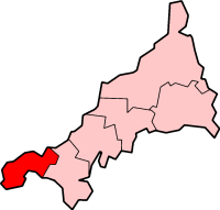
Penwith is an area of Cornwall, England, located on the peninsula of the same name. It is also the name of a former local government district, whose council was based in Penzance. The area is named after one of the ancient administrative hundreds of Cornwall which derives from two Cornish words, penn meaning 'headland' and wydh meaning 'at the end'.

<span class="mw-page-title-main">Porthleven</span> Port in England

Porthleven is a town, civil parish and fishing port near Helston, Cornwall, England, United Kingdom. The most southerly port in Great Britain, it was a harbour of refuge when this part of the Cornish coastline was infamous for wrecks in the days of sail. The South West Coast Path from Somerset to Dorset passes through the town. The population at the 2011 census was 3,059.

Poldhu is a small area in south Cornwall, England, UK, situated on the Lizard Peninsula; it comprises Poldhu Point and Poldhu Cove. Poldhu means "black pool" in Cornish. Poldhu lies on the coast of Mount's Bay and is in the northern part of the parish of Mullion; the churchtown is 2 kilometres (1.2 mi) to the south-east. On the north side of Poldhu Cove is the parish of Gunwalloe and the village of Porthleven is a further 7 kilometres (4.3 mi) to the north.

<span class="mw-page-title-main">Mousehole</span> Village in southwest Cornwall, England

Mousehole is a village and fishing port in Cornwall, England, UK. It is approximately 2.5 miles (4 km) south of Penzance on the shore of Mount's Bay. The village is in the civil parish of Penzance. An islet called St Clement's Isle lies about 350 metres (380 yd) offshore from the harbour entrance.

<span class="mw-page-title-main">Praa Sands</span> Village and beach in Cornwall, England

Praa Sands, commonly pronounced pray or prah, is a white-sand beach and coastal village in Cornwall, England. It is in the parish of Breage and lies off the A394 road between Helston and Penzance. Formerly serving the local mining industry, it is now mostly a tourist-orientated area. The beach is popular with surfers and walkers. Towards the south eastern end of the beach is a WW2 Type 24 pillbox. Originally this was constructed on top of the cliffs but it has been subjected to coastal erosion and has settled down onto the beach.

<span class="mw-page-title-main">Mullion Cove</span> Village in the United Kingdom

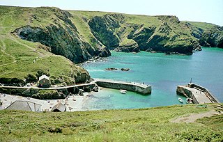
Mullion Cove, or Porth Mellin, is a small community on the West Coast of the Lizard Peninsula in Cornwall, England, and on the eastern side of Mount's Bay. The Cove forms part of the parish of Mullion, and is accessible by road from Mullion village, 1 mile (1.6 km) to the northeast, and also via the South West coast path. It lies within an Area of Outstanding Natural Beauty.

<span class="mw-page-title-main">Wherrytown</span>

Wherrytown is a small settlement in west Cornwall, United Kingdom, on the east side of the Laregan River, between Newlyn and Penzance. It was formerly in the civil parish of Madron and was incorporated into the Borough of Penzance in 1934 when local government was reorganised.

The Newlyn riots occurred in Newlyn, Cornwall, UK in May 1896. Cornish fishermen did not believe in landing fish on a Sunday, so other fleets exploited their opportunity. Locals retaliated by seizing non-Cornish vessels and throwing their catch overboard. This led to three days of rioting, quelled only by the intervention of a naval destroyer.

Bucca is a male sea-spirit in Cornish folklore, a merman, that inhabited mines and coastal communities as a hobgoblin during storms. The mythological creature is a type of water spirit likely related to the Púca from Irish, the Pwca from Welsh folklore, and the female mari-morgans, a type of mermaid from Welsh and Breton mythology. Rev W. S. Lach-Szyrma, one 19th-century writer on Cornish antiquities, suggested the Bucca had originally been an ancient pagan deity of the sea such as Irish Nechtan or British Nodens, though his claims are mainly conjecture. Folklore however records votive food offerings made on the beach similar to those made to the subterranean Knockers and may represent some form of continuity with early or pre-Christian Brittonic belief practices.

<span class="mw-page-title-main">Penlee Lifeboat Station</span> Base for Royal National Lifeboat Institution

Penlee Lifeboat Station is the base for Royal National Lifeboat Institution (RNLI) search and rescue operations for Mount's Bay in Cornwall, United Kingdom. The lifeboat station operated at various locations in Penzance from the early 19th century. It moved to Penlee Point near Mousehole in 1913, thus gaining its current name, but was moved to Newlyn in 1983 without any change of name. The station is remembered for the loss of the entire lifeboat crew on 19 December 1981.

<span class="mw-page-title-main">The Loe</span> Freshwater lake in Cornwall, England

The Loe, also known as Loe Pool, is the largest natural freshwater lake in Cornwall, United Kingdom. The earliest recorded appearance of this simple name form was in 1337, when it was called "La Loo", but is mentioned as 'the lake' in 1302; Situated between Porthleven and Gunwalloe and downstream of Helston, it is separated from Mount's Bay by the shingle bank of Loe Bar. Both the Loe and Loe Bar are situated within the Penrose Estate, which is administered by the National Trust, and are designated as a Site of Special Scientific Interest by Natural England. It is within the Cornwall Area of Outstanding Natural Beauty and is considered a classic Geological Conservation Review Site. The South West Coast Path, which follows the coast of south-west England from Somerset to Dorset passes over Loe Bar.

Presented below is an alphabetical index of articles related to Cornwall:

References

  1. Place-names in the Standard Written Form (SWF) Archived 15 May 2013 at the Wayback Machine  : List of place-names agreed by the MAGA Signage Panel Archived 15 May 2013 at the Wayback Machine . Cornish Language Partnership.
  2. Ordnance Survey: Landranger map sheet 203 Land's End ISBN   978-0-319-23148-7
  3. 1 2 Corin, J and Farr, G. (1983) Penlee Lifeboat. Penzance: Penzance and Penlee Branch of the RNLI.
  4. "Home - South West Coast Path".
  5. Lawman, J. (1994) A Natural History of the Lizard Peninsula. Pool: Institute of Cornish Studies.
  6. "GEOLOGICAL SKETCH MAP - MARAZION TO PORTHLEVEN" (PDF). Camborne School of Mines, University of Exeter.
  7. "SITE NOTIFIED TO THE SECRETARY OF STATE ON 31 MARCH 1995" (PDF). Natural England . Archived from the original (PDF) on 4 March 2016.
  8. 1 2 Tonkin, B., Covey, R. and Moat T. (1997) Start Point to Land’s End Maritime Natural Area. A Nature Conservation Profile. Truro: English Nature.
  9. Ordnance Survey Explorer 7; Land's End, Penzance and St. Ives, 1:25 000 scale. 1996
  10. 1 2 3 Howie, Frank (March 2014). Penzance's 4000 year old Fossil Forest. Cornwall Geoconservation Group.
  11. Bird, Eric (1998). The Coasts of Cornwall. Fowey: Alexander Associates. ISBN   1-899526-01-3.
  12. Pool, P. A. S. (1974) The History of the Town and Borough of Penzance. Penzance: The Corporation of Penzance.
  13. French, C.N. "THE 'SUBMERGED FOREST' PALAEOSOLS OF CORNWALL. Note of a paper read at the Annual Conference of the Ussher Society, January 1999" (PDF). Geoscience in South-west England. 9: 365–369. Archived from the original (PDF) on 2 April 2015. Retrieved 21 March 2015.
  14. Murphy, R.J., (1986). A Study of Loe Bar. In Cornish Studies 14:23–33.
  15. May, V.J. Loe Bar. In May, V.J. and Hansom, J.D. (2003) Coastal Geomorphology of Great Britain, Geological Conservation Review Series, No 28, Joint Nature Conservation Committee, Peterborough, 754 pp.
  16. "The Mounts Bay Marine Conservation Zone Designation Order 2016". legislation.gov.uk. Department for Environment, Food and Rural Affairs. Retrieved 29 January 2016.
  17. 1 2 "Mounts Bay MCZ – Feature Maps". GOVUK. Department for Environment, Food and Rural Affairs. Retrieved 29 January 2016.
  18. Bennallick Ian J; French Colin N; Parslow Rosemary E (2009). Vascular Plants. In Red Data Book for Cornwall and the Isles of Scilly (2nd ed.). Praze-an-Beeble: Croceago Press. pp. 105–157. ISBN   978-1-901685-01-5.
  19. Smallcombe, Mike (19 August 2018). "Incredibly rare white harbour porpoise spotted off the coast of Cornwall". Cornwall Live. Retrieved 20 August 2018.
  20. Matar, Nabil (1998). Islam in Britain, 1558–1685. Cambridge: Cambridge University Press. ISBN   9780521622332 . Retrieved 4 June 2014.
  21. Scourse, E.M.; Chapman, N.A.; Tappin, D.R.; Wallis, S.R., eds. (5 January 2018). Tsunamis: Geology, Hazards and Risks. GSL Special Publications. p. 152. ISBN   9781786203182.
  22. "Our Club". Mount's Bay Sailing Club. Retrieved 1 April 2024.
  23. "Dolly Pentreath - The last native speaker of the Cornish Language". Cornwall Guide. 2 March 2016. Retrieved 24 July 2022.
  24. Hamilton Jenkin 1962 , pp. 17–21
  25. Hamilton Jenkin 1962 , pp. 23–25

50°03′29″N5°25′13″W / 50.0580°N 5.4204°W / 50.0580; -5.4204