Mount Carrie

Last updated
Mount Carrie
Fairchild Glacier.jpg
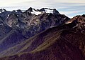
Mt. Carrie (right), Ruth Peak (left) and Fairchild Glacier
Highest point
Elevation 6,995 ft (2,132 m) [1]
Prominence 1,675 ft (511 m) [1]
Isolation 6.24 mi (10.04 km) [1]
Coordinates 47°53′39″N123°38′57″W / 47.894242°N 123.649295°W / 47.894242; -123.649295 [1]
Geography
USA Washington relief location map.jpg
Red triangle with thick white border.svg
Mount Carrie
Location of Mount Carrie in Washington
Usa edcp relief location map.png
Red triangle with thick white border.svg
Mount Carrie
Mount Carrie (the United States)
Location Olympic National Park
Clallam County, Washington, US
Parent range Olympic Mountains
Bailey Range
Topo map USGS Mount Carrie
Geology
Age of rock Eocene
Type of rock grey sandstone [2]
Climbing
Easiest route Scrambling YDS 2 via the High Divide Trail and Cat Walk [3]

Mount Carrie is a 6,995-foot (2,132-metre) mountain summit located within Olympic National Park in Clallam County of Washington state. [4] Mt. Carrie is the highest point in the Bailey Range which is a subrange of the Olympic Mountains. With a good eye and clear weather, the mountain can be seen from the visitor center at Hurricane Ridge. Its nearest higher peak is Mount Mathias (7,156 ft) which is an outlier of Mount Olympus, 6.24 mi (10.04 km) to the south. [1] Due to heavy winter snowfalls, Mount Carrie supports the Carrie Glacier in its northeast cirque, and Fairchild Glacier on the east slope. Precipitation runoff from the mountain drains into tributaries of the Elwha River and Hoh River. There is a scrambling route via the High Divide Trail and Cat Walk. [3]

Contents

History

The Olympic Peninsula was largely unmapped until surveyors Arthur Dodwell and Theodore Rixon mapped most of its topography between 1898 and 1900, and what is now Mt. Carrie, was in 1899 one of the last remaining unnamed mountains in the Olympic range. [5] The mountain was named by Theodore Rixon for his wife Caroline "Carrie" (Jones) Rixon. [6] Carrie Rixon was a noted artist, painter, singer, and taught music to children. The Rixons lived at a 160-acre homestead she called Fairholme at the west end of Lake Crescent, until they moved to Teahwhit Head in 1916. Carrie died on May 20, 1946. [6]

Climate

Based on the Köppen climate classification, Mount Carrie is located in the marine west coast climate zone of western North America. [7] Most weather fronts originate in the Pacific Ocean, and travel northeast toward the Olympic Mountains. As fronts approach, they are forced upward by the peaks of the Olympic Range, causing them to drop their moisture in the form of rain or snowfall (Orographic lift). As a result, the Olympics experience high precipitation, especially during the winter months. During winter months, weather is usually cloudy, but, due to high pressure systems over the Pacific Ocean that intensify during summer months, there is often little or no cloud cover during the summer. In terms of favorable weather, the best months for viewing and climbing are July through September.

See also

Related Research Articles

<span class="mw-page-title-main">Mount Angeles</span> Mountain in Washington (state), United States

Mount Angeles is located just south of Port Angeles, Washington in the Olympic National Park. It is the highest peak in the Hurricane Ridge area. The summit, which offers panoramic views of the Strait of Juan de Fuca and many of the peaks of the interior Olympic Mountains can be climbed from the Klahane Ridge trail.

<span class="mw-page-title-main">Mount Mystery</span> Mountain in Washington (state), United States

Mount Mystery is a prominent 7,639-foot (2,328-metre) mountain summit located in the Olympic Mountains in Jefferson County of Washington state. It is located within Olympic National Park on the Olympic Peninsula. Mount Mystery is the sixth-highest peak of the Olympic Mountains, after Mount Olympus, Mount Deception, Mount Constance, Mount Johnson, and Inner Constance. Its nearest higher neighbor is Mount Deception, 1.32 mi (2.12 km) to the north-northwest. Little Mystery (6941 ft) is a subsidiary summit south of Mount Mystery.

<span class="mw-page-title-main">Mount Meany</span> Mountain in Washington (state), United States

Mount Meany is a prominent 6,695-foot (2,041-metre) mountain summit located deep within Olympic National Park in Jefferson County of Washington state. With a good eye and clear weather, the top of the mountain can be seen from the visitor center at Hurricane Ridge. The nearest neighbor is Mount Noyes less than one mile to the south, and the nearest higher peak is Circe (6,847 ft) on Mount Olympus, 4.07 mi (6.55 km) to the northwest. There are scrambling routes on the east side, via Noyes-Meany col, and via the ridge from Mount Queets. Due to heavy winter snowfalls, Mount Meany supports several small glaciers on its north and east slopes, despite its modest elevation. Precipitation runoff from the mountain drains into the headwaters of both the Elwha and Queets Rivers.

<span class="mw-page-title-main">Mount Queets</span> Mountain in Washington (state), United States

Mount Queets is a 6,476-foot (1,974-metre) mountain summit located deep within Olympic National Park in Jefferson County of Washington state. With a good eye and clear weather, the top of the mountain can be seen from the visitor center at Hurricane Ridge. Its nearest higher peak is Mount Meany (6,695 ft), 0.8 mi (1.3 km) to the south. Due to heavy winter snowfalls, Mount Queets supports the Queets Glacier in a cirque on its north slope, despite its modest elevation. Precipitation runoff from the mountain drains into the headwaters of both the Elwha River and Queets River. There are scrambling routes ranging from class YDS 2 via the North Ridge, class 3 via the ridge from Mt. Meany, and class 4 via the Queets Glacier.

<span class="mw-page-title-main">Mount Tom (Washington)</span> Mountain in Washington (state), United States

Mount Tom is a remote 7,076-foot (2,157-metre) mountain summit located within Olympic National Park in Jefferson County of Washington state. Its nearest higher neighbor is Mount Olympus, 1.76 mi (2.83 km) to the east. Due to heavy winter snowfalls, Mount Tom supports the massive White Glacier on its northeast slope, despite its modest elevation. This glacier is the westernmost glacier in the contiguous states, and the summit is the westernmost peak higher than 7000+ feet elevation. Precipitation runoff from the mountain drains into tributaries of the Hoh River.

<span class="mw-page-title-main">Mount Fricaba</span> Mountain in Washington (state), United States

Mount Fricaba is a 7,139-foot-elevation (2,176 m) double summit mountain located in the Olympic Mountains, in Jefferson County of Washington state. It is situated on the shared border of Olympic National Park with Buckhorn Wilderness, and is the highest point in that wilderness, as well as the Olympic National Forest. Its nearest higher peak is Hal Foss Peak, 0.74 miles (1.19 km) to the southwest. Precipitation runoff from the peak drains east into headwaters of the Dungeness River, or west into Deception Creek which is a tributary of the Dosewallips River. The mountain's name was officially adopted in 1961 by the United States Board on Geographic Names based on usage by The Mountaineers since 1907, and inclusion in Fred Beckey's "Climber's Guide to the Cascade and Olympic Mountains of Washington" published in 1949. The first ascent of the mountain was made in 1957 by Don Bechlem and Jack Newman.

<span class="mw-page-title-main">Stephen Peak</span> Mountain in Washington (state), United States

Stephen Peak is a 6,418-foot (1,956-metre) mountain summit located within Olympic National Park in Jefferson County of Washington state. Stephen Peak is the fifth-highest peak in the Bailey Range, which is a subrange of the Olympic Mountains. In clear weather, the mountain can be seen from the visitor center at Hurricane Ridge, appearing to the left of Mount Olympus. Mount Ferry is set 2.26 mi (3.64 km) to the southeast, and Stephen's nearest higher neighbor is Ruth Peak which is an outlier of Mount Carrie, 2.1 mi (3.4 km) to the northwest. Precipitation runoff from the mountain drains into tributaries of the Elwha River and Hoh River. The first ascent of this peak was made in 1961 by Kent Heathershaw, Doug Waali, and Robert Wood.

<span class="mw-page-title-main">Mount Fitzhenry</span> Mountain in Washington (state), United States

Mount Fitzhenry is a 6,050-foot (1,840-metre) mountain summit located within Olympic National Park in Clallam County of Washington state. Mt. Fitzhenry is in the Bailey Range, which is a subrange of the Olympic Mountains. The mountain can be seen from the visitor center at Hurricane Ridge in clear weather. Its nearest higher neighbor is Mount Fairchild, 1.57 mi (2.53 km) to the south. Precipitation runoff from the mountain drains into tributaries of the Elwha River. Mount Fitzhenry is situated at the head of Fitzhenry Creek, and both are named for Edward Allen Fitzhenry (1868–1937), Clallam County surveyor from 1892-1900. President Woodrow Wilson appointed Fitzhenry as Washington Surveyor General in 1913, and he later served as Deputy State Land Commissioner.

<span class="mw-page-title-main">Mount Fairchild</span> Mountain in Washington (state), United States

Mount Fairchild, also known as Mount William Fairchild, is a 6,900-foot (2,100-metre) glaciated mountain summit located within Olympic National Park in Clallam County of Washington state. Mt. Fairchild is the second-highest peak in the Bailey Range, which is a subrange of the Olympic Mountains. Its nearest higher neighbor is Mount Carrie, 0.84 mi (1.35 km) to the southwest, and Ruth Peak is set 0.92 mi (1.48 km) to the south. In clear weather, the mountain can be seen from the visitor center at Hurricane Ridge. Precipitation runoff from the mountain drains into tributaries of the Elwha River.

<span class="mw-page-title-main">Mount Ferry</span> Mountain in Washington (state), United States

Mount Ferry is a 6,195-foot (1,888-metre) mountain summit located within Olympic National Park in Jefferson County of Washington state. Mount Ferry is the eighth-highest peak in the Bailey Range, which is a subrange of the Olympic Mountains. In clear weather, the mountain can be seen from the visitor center at Hurricane Ridge. Its nearest higher neighbor is Mount Pulitzer, 0.6 mi (0.97 km) to the southwest. Stephen Peak is set 2.26 mi (3.64 km) to the northwest, and Mount Olympus is 7.2 mi (11.6 km) to the southwest. Precipitation runoff from the mountain drains into tributaries of the Elwha and Hoh Rivers.

<span class="mw-page-title-main">Mount Pulitzer (Washington)</span> Mountain in Washington (state), United States

Mount Pulitzer, also known as Snagtooth, is a 6,283-foot (1,915-metre) mountain summit located within Olympic National Park in Jefferson County of Washington state. Mount Pulitzer is the sixth-highest peak in the Bailey Range, which is a subrange of the Olympic Mountains. Its nearest neighbor is Mount Ferry, 0.58 mi (0.93 km) to the northeast, and its nearest higher neighbor is Stephen Peak, 2.58 mi (4.15 km) to the north. Mount Olympus is set 6.8 mi (10.9 km) to the southwest. In clear weather, the mountain can be seen from the visitor center at Hurricane Ridge. Precipitation runoff from the mountain drains into tributaries of the Elwha and Hoh Rivers. The first ascent of the summit was made in 1961 by Doug Waali, Bob Wood, and Kent Heathershaw via the east ridge.

<span class="mw-page-title-main">Ruth Peak</span> Mountain in Washington (state), United States

Ruth Peak is a 6,850+ ft glaciated mountain summit located within Olympic National Park in Clallam County of Washington state. Ruth Peak is the third-highest peak in the Bailey Range, which is a subrange of the Olympic Mountains. Its nearest higher neighbor is Mount Carrie, 0.91 mi (1.46 km) to the northwest, and Mount Fairchild is set 0.92 mi (1.48 km) to the north. In clear weather, the mountain can be seen from the visitor center at Hurricane Ridge. Precipitation runoff from the mountain drains into tributaries of the Hoh and Elwha Rivers. The first ascent of this peak was made in 1961 by Bert Brown, Roy Etten, and Victor Nelson.

<span class="mw-page-title-main">Mount Worthington (Washington)</span> Mountain in Washington, USA

Mount Worthington is a 6,938-foot (2,115-metre) elevation double-summit mountain located in the eastern Olympic Mountains in Jefferson County of Washington state. It is set within Buckhorn Wilderness, on land managed by the Olympic National Forest. The nearest neighbor is Iron Mountain, 0.76 mi (1.22 km) to the southwest, and the nearest higher peak is Buckhorn Mountain, 1.3 mi (2.1 km) to the southwest. Precipitation runoff from Mount Worthington drains south into the Big Quilcene River, or north into Copper Creek which is a tributary of the Dungeness River. This mountain was first known as Copper Peak, but was renamed by Jack Christensen for the William J. Worthington family, pioneers of nearby Quilcene. Copper was mined in the Tubal Cain mine at the northern base of this mountain in the early 1900s. In the same vicinity of the abandoned mine are the remains of a modified B-17 plane that crashed on January 19, 1952, when returning from a search-and-rescue mission.

<span class="mw-page-title-main">Sundial (Olympic Mountains)</span> Mountain in Washington (state), United States

Sundial is a 7,200+ ft mountain summit located within Olympic National Park, in Jefferson County of Washington state. Sundial is part of The Needles range, which is a subrange of the Olympic Mountains. Its nearest higher neighbor is Mount Clark, 0.27 mi (0.43 km) to the northwest, and Mount Johnson is set 0.45 mi (0.72 km) to the west. The climbing routes on Sundial start at class 3 scrambling via the East Face, and range up to class 5 via the South Side Face. The first ascent of the mountain was made in 1944 by Adel and William Degenhardt. The mountain is so named because the time of day can be approximated as an observer in Royal Basin watches the sun's rays make their way down the east face of this mountain in the morning. Precipitation runoff from the mountain drains into Royal Creek which is a tributary of the Dungeness River.

<span class="mw-page-title-main">Mount Claywood</span> Mountain in Washington (state), United States

Mount Claywood is a 6,836-foot (2,084-metre) mountain summit located within Olympic National Park in Jefferson County of Washington state. It is situated at the head of Lost River, and 15 mi (24 km) east of Mount Olympus. Its nearest higher neighbor is Mount Cameron, 2.4 mi (3.9 km) to the northeast. Other nearby peaks include Mt. Fromme, 0.58 mi (0.93 km) to the southeast, and Sentinel Peak, 2 mi (3.2 km) also to the southeast. Precipitation runoff from the mountain drains north and west into tributaries of the Elwha River, and east into Claywood Lake, thence Dosewallips River.

<span class="mw-page-title-main">Athena (Olympic Mountains)</span> Mountain in Washington (state), United States

Athena is a 7,365-foot-elevation (2,245 meter) mountain summit located within Olympic National Park in Jefferson County of Washington state. Athena is situated at the head of the Hoh Glacier, and the Hubert Glacier lies below the west aspect. Its neighbors include Mount Olympus, 1.7 mi (2.7 km) to the northwest, and Aries 1.7 mi (2.7 km) to the northeast. Athena has subpeaks "Athena II" (7,259 ft), and "Athena's Owl" (7,000 ft). Precipitation runoff from the mountain drains into the Queets and Hoh Rivers, with Athena being the highest point within the Queets drainage basin.

<span class="mw-page-title-main">Mount Noyes (Washington)</span> Mountain in Washington (state), United States

Mount Noyes is a 6,173-foot (1,882 m) mountain summit located deep within Olympic National Park in Jefferson County of Washington state. Part of the Olympic Mountains, Mount Noyes is situated seven miles southeast of Mount Olympus, and set within the Daniel J. Evans Wilderness. The nearest higher neighbor is Mount Meany, 0.6 miles (0.97 km) to the north, and Mount Seattle rises one mile to the southeast. Noyes is a major triple divide point with precipitation runoff from the mountain draining east into the headwaters of the Elwha River, west into headwaters of Saghalie Creek which is a tributary of the Queets River, and south into headwaters of Seattle Creek which is a tributary of the Quinault River. Topographic relief is significant as the east, west, and south aspects of the peak each rise 2,200 feet (670 m) in approximately one mile.

The Bailey Range is a mountain range located within Olympic National Park in Washington state.

<span class="mw-page-title-main">Ludden Peak</span> Mountain in Washington (state), United States

Ludden Peak is a 5,854-foot (1,784-metre) mountain summit located within Olympic National Park in Jefferson County of Washington state. Ludden Peak is part of the Bailey Range, which is a subrange of the Olympic Mountains, and is set within the Daniel J. Evans Wilderness. In clear weather, the mountain can be seen from the park's visitor center on Hurricane Ridge. The nearest higher neighbor is Mount Scott, one mile to the south-southeast, line parent Mount Ferry rises 1.6 mi (2.6 km) to the southwest, Dodger Point is 1.9 mi (3.1 km) to the northeast, and Stephen Peak is set 2.7 mi (4.3 km) to the northwest. Precipitation runoff from the mountain drains into tributaries of the Elwha River.

<span class="mw-page-title-main">Cat Peak</span> Mountain in Washington (state), United States

Cat Peak is a 5,940-foot (1,810-metre) mountain summit within Olympic National Park in Clallam County of Washington state.

References

  1. 1 2 3 4 5 "Mount Carrie". Peakbagger.com.
  2. National Park Service Geology of the Olympic Peninsula
  3. 1 2 climbersguideolympics.com Mount Carrie
  4. "Mount Carrie". Geographic Names Information System . United States Geological Survey, United States Department of the Interior . Retrieved 2020-06-15.
  5. Majors, Harry M. (1975). Exploring Washington. Van Winkle Publishing Co. p. 71. ISBN   978-0-918664-00-6.
  6. 1 2 Parratt, Smitty (1984). Gods and Goblins: A Field Guide to Place Names of Olympic National Park (1st ed.).
  7. Peel, M. C.; Finlayson, B. L.; McMahon, T. A. (2007). "Updated world map of the Köppen−Geiger climate classification". Hydrol. Earth Syst. Sci. 11: 1633–1644. ISSN   1027-5606.