Cat Peak

Last updated
Cat Peak
Cat Peak from High Divide.jpg
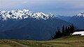
West aspect, seen from High Divide
(Mt. Carrie directly behind, and Mt. Fairchild to left)
Highest point
Elevation 5,940 ft (1,810 m) [1]
Prominence 750 ft (230 m) [2]
Parent peak Mount Carrie (6,995 ft) [3]
Isolation 1.49 mi (2.40 km) [3]
Coordinates 47°54′00″N123°40′48″W / 47.9001113°N 123.6800913°W / 47.9001113; -123.6800913 Coordinates: 47°54′00″N123°40′48″W / 47.9001113°N 123.6800913°W / 47.9001113; -123.6800913 [4]
Geography
USA Washington relief location map.jpg
Red triangle with thick white border.svg
Cat Peak
Location of Cat Peak in Washington
Usa edcp relief location map.png
Red triangle with thick white border.svg
Cat Peak
Cat Peak (the United States)
Location Olympic National Park
Clallam County, Washington, US
Parent range Olympic Mountains
Bailey Range [5]
Topo map USGS Mount Carrie
Geology
Age of rock Eocene
Climbing
First ascent Unknown [2]
Easiest route class 1 Hiking via High Divide Trail [2]

Cat Peak is a 5,940-foot (1,810-metre) mountain summit located within Olympic National Park in Clallam County of Washington state. [4]

Contents

Description

Set within the Daniel J. Evans Wilderness, Cat Peak is the westernmost peak of the Bailey Range, which is a subrange of the Olympic Mountains. With clear weather, the mountain can be seen by hikers from High Divide or Hurricane Hill. The nearest higher neighbor is Mount Carrie 1.24 mi (2.00 km) to the east-southeast, and Mount Olympus rises 6.84 mi (11.01 km) to the south. [5] Precipitation runoff from the mountain drains north into Cat Creek which is a tributary of the Elwha River, and south into the Hoh River. Topographic relief is significant as the summit rises over 4,400 feet (1,340 m) above the Hoh River in approximately one mile.

History

The mountain's name has been officially adopted by the U.S. Board on Geographic Names. The peak is named in association with Cat Creek, which heads on the peak. The creek was christened "Wildcat Creek" by the 1889–90 Seattle Press Expedition because an expedition member killed a bobcat on February 28, 1890, where the creek joins the Elwha River. [6]

Climate

Based on the Köppen climate classification, Cat Peak is located in the marine west coast climate zone of western North America. [7] Most weather fronts originate in the Pacific Ocean, and travel east toward the Olympic Mountains. As fronts approach, they are forced upward by the peaks of the Olympic Range, causing them to drop their moisture in the form of rain or snowfall (Orographic lift). As a result, the Olympics experience high precipitation, especially during the winter months. During winter months, weather is usually cloudy, but, due to high pressure systems over the Pacific Ocean that intensify during summer months, there is often little or no cloud cover during the summer. The months June through October offer the most favorable weather for viewing and climbing. [2]

Geology

The Olympic Mountains are composed of obducted clastic wedge material and oceanic crust, primarily Eocene sandstone, turbidite, and basaltic oceanic crust. [8] The mountains were sculpted during the Pleistocene era by erosion and glaciers advancing and retreating multiple times.

See also

Related Research Articles

Mount Angeles is located just south of Port Angeles, Washington in the Olympic National Park. It is the highest peak in the Hurricane Ridge area. The summit, which offers panoramic views of the Strait of Juan de Fuca and many of the peaks of the interior Olympic Mountains can be climbed from the Klahane Ridge trail.

Mount Meany

Mount Meany is a prominent 6,695-foot (2,041-metre) mountain summit located deep within Olympic National Park in Jefferson County of Washington state. With a good eye and clear weather, the top of the mountain can be seen from the visitor center at Hurricane Ridge. The nearest neighbor is Mount Noyes less than one mile to the south, and the nearest higher peak is Circe (6,847 ft) on Mount Olympus, 4.07 mi (6.55 km) to the northwest. There are scrambling routes on the east side, via Noyes-Meany col, and via the ridge from Mount Queets. Due to heavy winter snowfalls, Mount Meany supports several small glaciers on its north and east slopes, despite its modest elevation. Precipitation runoff from the mountain drains into the headwaters of both the Elwha and Queets Rivers.

Mount Carrie

Mount Carrie is a 6,995-foot (2,132-metre) mountain summit located within Olympic National Park in Clallam County of Washington state. Mt. Carrie is the highest point in the Bailey Range which is a subrange of the Olympic Mountains. With a good eye and clear weather, the mountain can be seen from the visitor center at Hurricane Ridge. Its nearest higher peak is Mount Mathias (7,156 ft) which is an outlier of Mount Olympus, 6.24 mi (10.04 km) to the south. Due to heavy winter snowfalls, Mount Carrie supports the Carrie Glacier in its northeast cirque, and Fairchild Glacier on the east slope. Precipitation runoff from the mountain drains into tributaries of the Elwha River and Hoh River. There is a scrambling route via the High Divide Trail and Cat Walk.

Mount Tom (Washington)

Mount Tom is a remote 7,076-foot (2,157-metre) mountain summit located within Olympic National Park in Jefferson County of Washington state. Its nearest higher neighbor is Mount Olympus, 1.76 mi (2.83 km) to the east. Due to heavy winter snowfalls, Mount Tom supports the massive White Glacier on its northeast slope, despite its modest elevation. This glacier is the westernmost glacier in the contiguous states, and the summit is the westernmost peak higher than 7000+ feet elevation. Precipitation runoff from the mountain drains into tributaries of the Hoh River.

Stephen Peak

Stephen Peak is a 6,418-foot (1,956-metre) mountain summit located within Olympic National Park in Jefferson County of Washington state. Stephen Peak is the fifth-highest peak in the Bailey Range, which is a subrange of the Olympic Mountains. In clear weather, the mountain can be seen from the visitor center at Hurricane Ridge, appearing to the left of Mount Olympus. Mount Ferry is set 2.26 mi (3.64 km) to the southeast, and Stephen's nearest higher neighbor is Ruth Peak which is an outlier of Mount Carrie, 2.1 mi (3.4 km) to the northwest. Precipitation runoff from the mountain drains into tributaries of the Elwha River and Hoh River. The first ascent of this peak was made in 1961 by Kent Heathershaw, Doug Waali, and Robert Wood.

Mount Fairchild

Mount Fairchild, also known as Mount William Fairchild, is a 6,900-foot (2,100-metre) glaciated mountain summit located within Olympic National Park in Clallam County of Washington state. Mt. Fairchild is the second-highest peak in the Bailey Range, which is a subrange of the Olympic Mountains. Its nearest higher neighbor is Mount Carrie, 0.84 mi (1.35 km) to the southwest, and Ruth Peak is set 0.92 mi (1.48 km) to the south. In clear weather, the mountain can be seen from the visitor center at Hurricane Ridge. Precipitation runoff from the mountain drains into tributaries of the Elwha River.

Mount Ferry

Mount Ferry is a 6,195-foot (1,888-metre) mountain summit located within Olympic National Park in Jefferson County of Washington state. Mount Ferry is the eighth-highest peak in the Bailey Range, which is a subrange of the Olympic Mountains. In clear weather, the mountain can be seen from the visitor center at Hurricane Ridge. Its nearest higher neighbor is Mount Pulitzer, 0.6 mi (0.97 km) to the southwest. Stephen Peak is set 2.26 mi (3.64 km) to the northwest, and Mount Olympus is 7.2 mi (11.6 km) to the southwest. Precipitation runoff from the mountain drains into tributaries of the Elwha and Hoh Rivers.

Mount Pulitzer (Washington)

Mount Pulitzer, also known as Snagtooth, is a 6,283-foot (1,915-metre) mountain summit located within Olympic National Park in Jefferson County of Washington state. Mount Pulitzer is the sixth-highest peak in the Bailey Range, which is a subrange of the Olympic Mountains. Its nearest neighbor is Mount Ferry, 0.58 mi (0.93 km) to the northeast, and its nearest higher neighbor is Stephen Peak, 2.58 mi (4.15 km) to the north. Mount Olympus is set 6.8 mi (10.9 km) to the southwest. In clear weather, the mountain can be seen from the visitor center at Hurricane Ridge. Precipitation runoff from the mountain drains into tributaries of the Elwha and Hoh Rivers.

Ruth Peak

Ruth Peak is a 6,850+ ft glaciated mountain summit located within Olympic National Park in Clallam County of Washington state. Ruth Peak is the third-highest peak in the Bailey Range, which is a subrange of the Olympic Mountains. Its nearest higher neighbor is Mount Carrie, 0.91 mi (1.46 km) to the northwest, and Mount Fairchild is set 0.92 mi (1.48 km) to the north. In clear weather, the mountain can be seen from the visitor center at Hurricane Ridge. Precipitation runoff from the mountain drains into tributaries of the Hoh and Elwha Rivers. The first ascent of this peak was made in 1961 by Bert Brown, Roy Etten, and Victor Nelson.

Mount Mathias

Mount Mathias is a 7,156-foot (2,181-metre) mountain summit located within Olympic National Park in Jefferson County of Washington state. Its nearest higher neighbor is Mount Olympus, 1.76 mi (2.83 km) to the east. Mount Mathias is wedged between the massive Blue Glacier below its west slope, and the Hoh Glacier on the east side. Precipitation runoff from the mountain drains into the Hoh River.

Aries (mountain)

Aries is a 6,533-foot (1,991-metre) mountain summit located within Olympic National Park in Jefferson County of Washington state. Its neighbors include Mount Olympus, 2.46 mi (3.96 km) to the west, Athena 1.7 mi (2.7 km) to the southwest, and Mount Mathias 1.11 mi (1.79 km) to the northwest. Aries is wedged between the Hoh Glacier and the Humes Glacier, and immediately northeast of Blizzard Pass. Precipitation runoff from the mountain drains into headwaters of the Queets and Hoh Rivers. This mountain was named by glaciologists Richard Hubley and Edward LaChapelle in 1955, in preparation for the International Geophysical Year. It is named for Aries in keeping with the Greek and Roman mythology naming theme surrounding Mount Olympus.

Mount Claywood

Mount Claywood is a 6,836-foot (2,084-metre) mountain summit located within Olympic National Park in Jefferson County of Washington state. It is situated at the head of Lost River, and 15 mi (24 km) east of Mount Olympus. Its nearest higher neighbor is Mount Cameron, 2.4 mi (3.9 km) to the northeast. Other nearby peaks include Mt. Fromme, 0.58 mi (0.93 km) to the southeast, and Sentinel Peak, 2 mi (3.2 km) also to the southeast. Precipitation runoff from the mountain drains north and west into tributaries of the Elwha River, and east into Claywood Lake, thence Dosewallips River.

Athena (Olympic Mountains)

Athena is a 7,365-foot-elevation (2,245 meter) mountain summit located within Olympic National Park in Jefferson County of Washington state. Athena is situated at the head of the Hoh Glacier, and the Hubert Glacier lies below the west aspect. Its neighbors include Mount Olympus, 1.7 mi (2.7 km) to the northwest, and Aries 1.7 mi (2.7 km) to the northeast. Athena has subpeaks "Athena II" (7,259 ft), and "Athena's Owl" (7,000 ft). Precipitation runoff from the mountain drains into the Queets and Hoh Rivers, with Athena being the highest point within the Queets drainage basin.

McCartney Peak

McCartney Peak is a 6,784-foot-elevation (2,068 meter) mountain summit located within Olympic National Park in Jefferson County of Washington state. Part of the Olympic Mountains, McCartney Peak is situated 18 miles south of Port Angeles, and set within the Daniel J. Evans Wilderness. Topographic relief is significant as the southwest aspect rises 3,800 feet (1,160 meters) above the Lost River in approximately 1.5 mile. Precipitation runoff from the mountain drains north into headwaters of the Lillian River, east to the Gray Wolf River via Cameron Creek, and west to the Elwha River via Lost River. The nearest higher neighbor is line parent Mount Cameron, 3.1 mi (5.0 km) to the southeast.

Mount Noyes (Washington)

Mount Noyes is a 6,173-foot (1,882-metre) mountain summit located deep within Olympic National Park in Jefferson County of Washington state. Part of the Olympic Mountains, Mount Noyes is situated seven miles southeast of Mount Olympus, and set within the Daniel J. Evans Wilderness. The nearest higher neighbor is Mount Meany, 0.6 mile to the north, and Mount Seattle rises one mile to the southeast. Noyes is a major triple divide point with precipitation runoff from the mountain draining east into the headwaters of the Elwha River, west into headwaters of Saghalie Creek which is a tributary of the Queets River, and south into headwaters of Seattle Creek which is a tributary of the Quinault River. Topographic relief is significant as the east, west, and south aspects of the peak each rise 2,200 feet (670 m) in approximately one mile.

Mount Seattle (Washington)

Mount Seattle is a 6,246-foot (1,904-metre) mountain summit located deep within Olympic National Park in Jefferson County of Washington state. Part of the Olympic Mountains, Mount Seattle is situated 7.5 miles southeast of Mount Olympus, and set within the Quinault Rainforest and Daniel J. Evans Wilderness. The nearest higher neighbor is Mount Meany, 1.65 mile to the north-northwest, and Mount Noyes rises one mile to the northwest. Precipitation runoff from the mountain drains north into headwaters of the Elwha River, and south into tributaries of the Quinault River. Topographic relief is significant as the northeast aspect of the peak rises over 3,800 feet (1,160 m) above the Elwha valley in approximately 1.5 mile. Low Divide forms the saddle between Mt. Seattle and Mount Christie.

Mount Wilder

Mount Wilder is a 5,939-foot (1,810-metre) mountain summit located near the head of the Elwha Valley, deep within Olympic National Park in Jefferson County of Washington state. Part of the Olympic Mountains, Wilder represents the southernmost peak of the Bailey Range. It is situated 8.7 miles east-southeast of Mount Olympus, and is set within the Daniel J. Evans Wilderness. Neighbors include line parent Mount Dana, 2.3 miles (3.7 km) to the northeast, and Mount Seattle rises 3.7 miles to the southwest. The headwaters of the Goldie River form on the south slope of the mountain, and precipitation runoff from the mountain drains into Goldie River and other tributaries of the Elwha River. Topographic relief is significant as the south aspect of the peak rises nearly 3,800 feet (1,160 m) in less than two miles.

Mount Delabarre Mountain summit in Washington state

Mount Delabarre is a remote 6,024-foot (1,836-metre) mountain summit located deep within Olympic National Park in Jefferson County of Washington state. Part of the Olympic Mountains, Mount Delabarre is situated 12.4 miles southeast of Mount Olympus, and is set within the Daniel J. Evans Wilderness. The nearest higher neighbor is line parent Mount Christie, 2.5 miles to the west-northwest. Precipitation runoff from the mountain drains north into headwaters of Delabarre Creek, which is a tributary of the Elwha River, and south into Rustler Creek, which is a tributary of the North Fork Quinault River. Topographic relief is significant as the southwest aspect of the peak rises 3,400 feet (1,036 m) above Rustler Creek in approximately one mile.

Bailey Range

The Bailey Range is a mountain range located within Olympic National Park in Washington state.

Ludden Peak

Ludden Peak is a 5,854-foot (1,784-metre) mountain summit located within Olympic National Park in Jefferson County of Washington state. Ludden Peak is part of the Bailey Range, which is a subrange of the Olympic Mountains, and is set within the Daniel J. Evans Wilderness. In clear weather, the mountain can be seen from the park's visitor center on Hurricane Ridge. The nearest higher neighbor is Mount Scott, one mile to the south-southeast, line parent Mount Ferry rises 1.6 mi (2.6 km) to the southwest, and Stephen Peak is set 2.7 mi (4.3 km) to the northwest. Precipitation runoff from the mountain drains into tributaries of the Elwha River.

References

  1. Olympic Mountain Rescue, Olympic Mountains: A Climbing Guide, 4th Edition, 2006, Mountaineers Books, ISBN   9780898862065, page 191.
  2. 1 2 3 4 "Cat Peak - Climbers Guide to the Olympic Mountains". climbersguideolympics.com. Retrieved 2022-01-19.
  3. 1 2 "Cat Peak - 5,925' WA". listsofjohn.com. Retrieved 2022-01-19.
  4. 1 2 "Cat Peak". Geographic Names Information System . United States Geological Survey . Retrieved 2022-01-19.
  5. 1 2 "Cat Peak". Peakbagger.com.
  6. Parratt, Smitty (1984). Gods and Goblins: A Field Guide to Place Names of Olympic National Park (1st ed.).
  7. Peel, M. C.; Finlayson, B. L.; McMahon, T. A. (2007). "Updated world map of the Köppen−Geiger climate classification". Hydrol. Earth Syst. Sci. 11: 1633–1644. ISSN   1027-5606.
  8. Alt, D.D.; Hyndman, D.W. (1984). Roadside Geology of Washington. pp. 249–259. ISBN   0-87842-160-2.