Mount Fitzhenry is a 6,050-foot (1,840-metre) mountain summit located within Olympic National Park in Clallam County of Washington state.[4] Mt. Fitzhenry is in the Bailey Range, which is a subrange of the Olympic Mountains. The mountain can be seen from the visitor center at Hurricane Ridge in clear weather. Its nearest higher neighbor is Mount Fairchild, 1.57mi (2.53km) to the south.[1] Precipitation runoff from the mountain drains into tributaries of the Elwha River. Mount Fitzhenry is situated at the head of Fitzhenry Creek, and both are named for Edward Allen Fitzhenry (1868–1937), Clallam County surveyor from 1892-1900.[5] President Woodrow Wilson appointed Fitzhenry as Washington Surveyor General in 1913, and he later served as Deputy State Land Commissioner.[6]
Based on the Köppen climate classification, Mount Fitzhenry is located in the marine west coast climate zone of western North America.[7] Most weather fronts originate in the Pacific Ocean, and travel northeast toward the Olympic Mountains. As fronts approach, they are forced upward by the peaks of the Olympic Range, causing them to drop their moisture in the form of rain or snowfall (Orographic lift). As a result, the Olympics experience high precipitation, especially during the winter months. During winter, weather is usually cloudy, but, due to high-pressure systems over the Pacific Ocean that intensify during summer, there is often little or no cloud cover during the summer. In terms of favorable weather, the best months for viewing and climbing are July through September.
Geology
The Olympic Mountains are composed of obductedclastic wedge material and oceanic crust, primarily Eocenesandstone, turbidite, and basaltic oceanic crust.[8] The mountains were sculpted during the Pleistocene era by erosion and glaciers advancing and retreating multiple times.
Gallery
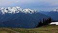
Mount Fitzhenry centered
Mount Fitzhenry centered, Hurricane Ridge Visitor Center on the right
This page is based on this Wikipedia article Text is available under the CC BY-SA 4.0 license; additional terms may apply. Images, videos and audio are available under their respective licenses.