| Mount Gayley | |
|---|---|
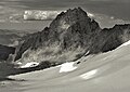
 Southwest aspect | |
| Highest point | |
| Elevation | 13,516 ft (4,120 m) [1] |
| Prominence | 430 ft (130 m) [1] |
| Parent peak | Mount Sill [2] |
| Coordinates | 37°06′11″N118°29′59″W / 37.1030007°N 118.4998074°W [3] |
| Naming | |
| Etymology | Charles Mills Gayley |
| Geography | |
 Mount Gayley  Mount Gayley | |
| Country | United States |
| State | California |
| County | Inyo |
| Protected area | John Muir Wilderness |
| Parent range | Sierra Nevada [1] |
| Topo map | USGS Split Mountain |
| Climbing | |
| First ascent | 1927 by Norman Clyde [4] |
| Easiest route | Exposed scramble, class 3 [2] |
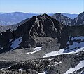
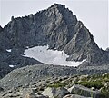
Mount Gayley is a 13,510-foot-elevation (4,120-meter) mountain summit located one mile east of the crest of the Sierra Nevada mountain range in Inyo County, California, United States. [3] It is situated in the Palisades area of the John Muir Wilderness, on land managed by Inyo National Forest. It is approximately 13 miles (21 km) west-southwest of the community of Big Pine, 0.67 miles (1.08 km) southwest of Temple Crag, and 0.5 miles (0.80 km) north-northeast of parent Mount Sill. Mount Gayley ranks as the 59th highest summit in California. [2]