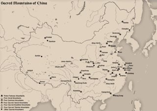
Mount Jianglang

Last updated
Mount Jianglang
Jiāngláng Shān
China edcp relief location map.jpg
Red triangle with thick white border.svg
Mount Jianglang
Location in Eastern China
Highest point
Elevation 816.8 m (2,680 ft) [1]
Listing List of mountains of China
Coordinates 28°31′47″N118°33′55″E / 28.52972°N 118.56528°E / 28.52972; 118.56528 Coordinates: 28°31′47″N118°33′55″E / 28.52972°N 118.56528°E / 28.52972; 118.56528
Geography
Location Zhejiang, China

Jianglangshan or Mount Jianglang (Chinese :江郎山; pinyin :Jiāngláng Shān) is a mountain in Jiangshan, Zhejiang, China. Three peaks from north to south make its recognizable "river-shaped" arrangement, as follows: Lang Feng, Ya Feng and Ling Feng. Lang Feng has elevation of 816.8 m (2,680 ft). [1]

Chinese language family of languages

Chinese is a group of related, but in many cases not mutually intelligible, language varieties, forming the Sinitic branch of the Sino-Tibetan language family. Chinese is spoken by the ethnic Chinese majority and many minority ethnic groups in China. About 1.2 billion people speak some form of Chinese as their first language.

Hanyu Pinyin, often abbreviated to pinyin, is the official romanization system for Standard Chinese in mainland China and to some extent in Taiwan. It is often used to teach Standard Mandarin Chinese, which is normally written using Chinese characters. The system includes four diacritics denoting tones. Pinyin without tone marks is used to spell Chinese names and words in languages written with the Latin alphabet, and also in certain computer input methods to enter Chinese characters.

Mountain A large landform that rises fairly steeply above the surrounding land over a limited area

A mountain is a large landform that rises above the surrounding land in a limited area, usually in the form of a peak. A mountain is generally steeper than a hill. Mountains are formed through tectonic forces or volcanism. These forces can locally raise the surface of the earth. Mountains erode slowly through the action of rivers, weather conditions, and glaciers. A few mountains are isolated summits, but most occur in huge mountain ranges.

The mountain exhibits Danxia landform, and was inscribed onto the World Heritage List in August 2010 as part of China Danxia. [2]

Danxia landform

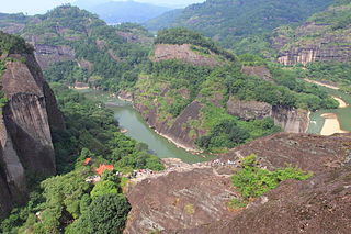
The Danxia landform refers to various landscapes found in southeast, southwest and northwest China that "consist of a red bed characterized by steep cliffs". It is a unique type of petrographic geomorphology found in China. Danxia landform is formed from red-coloured sandstones and conglomerates of largely Cretaceous age. The landforms look very much like karst topography that forms in areas underlain by limestones, but since the rocks that form danxia are sandstones and conglomerates, they have been called "pseudo-karst" landforms. They were formed by endogenous forces and exogenous forces.

In September 2013, Mount Jianglang was the scene for a stunt by Jeb Corliss where he flew between two of the peaks in a wing suit, starting the jump from a helicopter. [3]

Stunt unusual and difficult physical feat

A stunt is an unusual and difficult physical feat or an act requiring a special skill, performed for artistic purposes usually on television, theatre, or cinema. Stunts are a feature of many action films. Before computer generated imagery special effects, these effects were limited to the use of models, false perspective and other in-camera effects, unless the creator could find someone willing to jump from car to car or hang from the edge of a skyscraper: the stunt performer or stunt double.

Jeb Corliss is an American professional skydiver and BASE jumper. He has jumped from sites including Paris' Eiffel Tower, Seattle's Space Needle, the Christ the Redeemer statue in Rio de Janeiro and the Petronas Twin Towers in Kuala Lumpur, Malaysia. He lives in Venice, California.

Jiangshan Jianglangshan 2012.07.01 13-08-31.jpg

Related Research Articles

Mount Tai mountain

Mount Tai is a mountain of historical and cultural significance located north of the city of Tai'an, in Shandong province, China. The tallest peak is the Jade Emperor Peak, which is commonly reported as 1,545 metres (5,069 ft) tall, but is described by the PRC government as 1,532.7 metres (5,029 ft).

Mount Lao mountain in Peoples Republic of China

Mount Lao, or Laoshan is a mountain located near the East China Sea on the southeastern coastline of the Shandong Peninsula in China. The mountain is culturally significant due to its long affiliation with Taoism and is often regarded as one of the "cradles of Taoism". It is the highest coastal mountain in China and the second highest mountain in Shandong, with the highest peak (Jufeng) reaching 1,132.7 metres (3,716 ft). The mountain lies about 30 kilometres (19 mi) to the northeast of the downtown area of the City of Qingdao and is protected by the Qingdao Laoshan National Park that covers an area of 446 square kilometers.

Mount Wutai mountain

Mount Wutai, also known by its Chinese name Wutaishan and as Mount Qingliang, is a sacred Buddhist site at the headwaters of the Qingshui in Shanxi Province, China. Its central area is surrounded by a cluster of flat-topped peaks roughly corresponding to the cardinal directions. The north peak is the highest and is also the highest point in northern China.

Huangshan mountain range in southern Anhui province in eastern China

Huangshan is a mountain range in southern Anhui province in eastern China. Vegetation on the range is thickest below 1,100 meters (3,600 ft), with trees growing up to the treeline at 1,800 meters (5,900 ft).

Purple Mountain (Nanjing) mountain in Nanjing, Jiangsu, China

Purple Mountain or Zijin Shan is located on the eastern side of Nanjing in Jiangsu province, China. It is 448.2 m (1467 ft) high, with the lowest point 30 m (98 ft). Its peaks are often found enveloped in mysterious purple and golden clouds at dawn and dusk, hence its name.

Mount Song mountain

Mount Song is a mountain in central China's Henan Province, along the southern bank of the Yellow River, that is known as the central mountain of the Five Great Mountains of China. Its summit is 1,500 metres (4,900 ft) above sea level.

Sacred Mountains of China Wikimedia list article

The Sacred Mountains of China are divided into several groups. The Five Great Mountains refers to five of the most renowned mountains in Chinese history, and they were the subjects of imperial pilgrimage by emperors throughout ages. They are associated with the supreme God of Heaven and the five main cosmic deities of Chinese traditional religion. The group associated with Buddhism is referred to as the Four Sacred Mountains of Buddhism, and the group associated with Taoism is referred to as the Four Sacred Mountains of Taoism.

Mount Danxia mountain range

Mount Danxia is a noted scenic mountainous area near Shaoguan city in the northern part of Guangdong, People's Republic of China.

Nanling Mountains Mountain range in Southern China

The Nanling, also known as the Wuling, is a major mountain range in Southern China that separates the Pearl River Basin from the Yangtze Valley and serves as the dividing line between south and central subtropical zones. The main range of Nanling Mountains stretch west to east about 600 kilometers (370 mi) from Guilin and Hezhou of the eastern Guangxi to Ganzhou of the southern Jiangxi, north to south about 200 kilometres (120 mi) from Yongzhou and Chenzhou of the southern Hunan to Qingyuan and Shaoguan of the northern Guangdong; With its branches, the whole mountains run west to east 1,400 kilometers (870 mi).

Mount Longhu mountain

Mount Longhu, is located in Jiangxi, China. It is famous for being one of the birthplaces of Taoism, with many Taoist temples built upon the mountainside. It is particularly important to the Zhengyi Dao as it the Shangqing Temple and the Mansion of the Taoist Master are located here. It is known as one of the Four Sacred Mountains of Taoism.

Pagoda Forest at Shaolin Temple cemetery

The Pagoda Forest at Shaolin Temple refers to a number of stone or brick pagodas built in Henan province, China from 791 AD during the Tang Dynasty through the Song Dynasty, Yuan Dynasty, Ming Dynasty, and Qing Dynasty.

Renhua County County in Guangdong, Peoples Republic of China

Renhua is a county of northernmost Guangdong province, China, bordering Jiangxi to the northeast and Hunan to the northwest. It is under the administration of Shaoguan City.

Mount Siguniang mountain

Mount Siguniang is the highest mountain of Qionglai Mountains in Western China. It is located in the bordering area of Rilong Town, Xiaojin County and Wenchuan County in Ngawa Tibetan and Qiang Autonomous Prefecture, Sichuan Province.

Zhangye National Geopark national geopark in China

The Zhangye National Geopark is located in Sunan and Linze counties within the prefecture-level city of Zhangye, in Gansu, China. It covers an area of 322 square kilometres (124 sq mi). The site became a quasi-national geopark on April 23, 2012. It was formally designated as "Zhangye National Geopark" by the Ministry of Land and Resources on June 16, 2016 after it has passed the on-site acceptance test. Known for its colorful rock formations, it has been voted by Chinese media outlets as one of the most beautiful landforms in China.

Feng Shaoshun is a Chinese football player who currently plays for China League One side Shijiazhuang Ever Bright.

Mount Langshan

Langshan or Mount Lang is a mountain and a scenic area in Xinning County, Hunan, China. It is described on the local signage as a "world famous UNESCO geopark of China". Its peak elevation is 818 metres (2,684 ft).

References

  1. 1 2 测绘局公布盘山等第二批31座著名风景名胜山峰高程新数据 (in Chinese). Retrieved 2012-04-08.
  2. "China's unique red rock landform included on World Heritage List". People's Daily Online. August 2, 2010. Retrieved 2012-04-08.
  3. Ian Williams (29 September 2013). "Jeb Corliss flies through a narrow crack in Mount Jianglang". cctv.com English. China Central Television (CCTV). Retrieved 29 September 2013.