
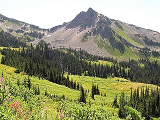
Mount Constance is a peak in the Olympic Mountains of Washington and the third highest in the range. It is the most visually prominent peak on Seattle's western skyline. Despite being almost as tall as the ice-clad Mount Olympus to the west, Mount Constance has little in the way of glaciers and permanent snow because the eastern, and particularly this northeastern, portion of the Olympics receives far less precipitation. However the narrow and steep Crystal Glacier still exists on the mountain's north face, shaded by the bulk of the main peak and with a small lake at its terminus. In addition, the treeline is higher here than mountains to the west, also hinting at the drier alpine conditions.

Mount Deception is a peak in the Olympic Mountains of Cascadia. It is in Olympic National Park on the Olympic Peninsula in the U.S. state of Washington.

Mount Stone is a 6,612-foot (2,015 m) peak in the Olympic Mountains. It is the highest point in Mason County, Washington and exceeds 2,000 feet (610 m) in prominence.

Mount Skokomish is a 6,434-foot (1,961 meter) mountain summit located in the Olympic Mountains, in Mason County of Washington state, United States. It is situated on the shared boundary of Olympic National Park with Mount Skokomish Wilderness, and it is the highest point of the wilderness. The nearest higher peak is Mount Stone, 1.66 mi (2.67 km) to the northeast. It is visible on the Olympic skyline from as far away as Seattle. Mt. Skokomish has three summits, the south peak being the highest. Precipitation runoff drains into the Hamma Hamma River and Skokomish River. Like the river, the mountain's toponym honors the Skokomish people.

Mount Cruiser is a 6,104-foot-elevation (1,860-meter) mountain summit located in the Olympic Mountains, in Mason County of Washington state, United States. It is situated in Mount Skokomish Wilderness on land managed by Olympic National Forest. Cruiser is the highest point on Sawtooth Ridge, and its nearest higher peak is Mount Skokomish, 2.1 mi (3.4 km) to the north-northeast. Cruiser has two sub-peaks, Alpha, and Beta, the latter of which lies on the Olympic National Park boundary. The first ascent of the peak was made in 1937 by Paul Crews and Ray Layton. The mountain was named by the first ascent party to recognize their club, the Bremerton Ski Cruisers. The mountain's toponym was officially adopted in 1961 by the United States Board on Geographic Names. Precipitation runoff from the mountain drains into the Hamma Hamma River.

Mount Claywood is a 6,836-foot (2,084-metre) mountain summit located within Olympic National Park in Jefferson County of Washington state. It is situated at the head of Lost River, and 15 mi (24 km) east of Mount Olympus. Its nearest higher neighbor is Mount Cameron, 2.4 mi (3.9 km) to the northeast. Other nearby peaks include Mt. Fromme, 0.58 mi (0.93 km) to the southeast, and Sentinel Peak, 2 mi (3.2 km) also to the southeast. Precipitation runoff from the mountain drains north and west into tributaries of the Elwha River, and east into Claywood Lake, thence Dosewallips River.

Mount Lena is a 5,995-foot-elevation mountain summit located in the Olympic Mountains, in Jefferson County of Washington state. It is situated within Olympic National Park, immediately north and 1,500 feet above the shore of Upper Lena Lake. Mt. Lena has a subsidiary peak, East Peak (5800+ ft/1768+ m), which lies northeast of the lake. Mount Bretherton lies across the lake to the south, Mount Stone is three miles to the southwest, and The Brothers approximately 3.5 miles to the northeast. Precipitation runoff from the mountain drains north to the Duckabush River, and south into the Hamma Hamma River via Lena Creek. The non-technical ascent of Mount Lena involves hiking eight miles (one-way) and 5,300 feet elevation gain via the Upper Lena Lake Trail and cross-country above the lake, with most favorable conditions from July through September. There are pleasant campsites at the lake, and the ascent to the summit takes 1.5 hour from the lake. This mountain's toponym has been officially adopted by the United States Board on Geographic Names.

Athena is a 7,365-foot-elevation (2,245 meter) mountain summit located within Olympic National Park in Jefferson County of Washington state. Athena is situated at the head of the Hoh Glacier, and the Hubert Glacier lies below the west aspect. Its neighbors include Mount Olympus, 1.7 mi (2.7 km) to the northwest, and Aries 1.7 mi (2.7 km) to the northeast. Athena has subpeaks "Athena II" (7,259 ft), and "Athena's Owl" (7,000 ft). Precipitation runoff from the mountain drains into the Queets and Hoh Rivers, with Athena being the highest point within the Queets drainage basin.

Blue Mountain is a 6,004-foot-elevation (1,830-meter) mountain summit located within Olympic National Park in Clallam County of Washington state. Blue Mountain is situated in the Daniel J. Evans Wilderness, 13 miles southeast of Port Angeles and 11 miles southwest of Sequim. Topographic relief is significant as the south aspect rises 4,000 feet above Gray Wolf River in approximately 2.5 miles. The mountain's name is due to a soft, blue haze that forms around the mountain in the summer. New settlers to the Olympic Peninsula near the end of the 19th century brought devastating fires started by land clearing and logging activities. The Dungeness Fire of 1891 burned about 30,000 acres, destroying much of the forest around Blue Mountain.

Mount Seattle is a 6,246-foot (1,904-metre) mountain summit deep within Olympic National Park in Jefferson County of Washington state. Part of the Olympic Mountains, Mount Seattle is situated 7.5 miles southeast of Mount Olympus, and set within the Quinault Rainforest and Daniel J. Evans Wilderness. The nearest higher neighbor is Mount Meany, 1.65 miles (2.66 km) to the north-northwest, and Mount Noyes rises one mile to the northwest. Precipitation runoff from the mountain drains north into headwaters of the Elwha River, and south into tributaries of the Quinault River. Topographic relief is significant as the northeast aspect of the peak rises over 3,800 feet (1,200 m) above the Elwha valley in approximately 1.5-mile. Low Divide forms the saddle between Mt. Seattle and Mount Christie.

Mount Lincoln is a 5,868-foot (1,789-meter) mountain summit located in the Olympic Mountains, in Mason County of Washington state, United States. It is situated on the boundary shared by Daniel J. Evans Wilderness and Mount Skokomish Wilderness, as well as the shared common border of Olympic National Park with Olympic National Forest. Lincoln is the second-highest point on Sawtooth Ridge, and the nearest higher neighbor is Mount Cruiser, 1.1 mi (1.8 km) to the northeast. Lincoln has two sub-peaks: a North Peak, and a Southwest Peak. Flapjack Lakes lie immediately west below the north sub-peak. Topographic relief is significant as the summit rises over 5,100 feet (1,600 m) above the Staircase Ranger Station at Lake Cushman in approximately two miles. Precipitation runoff from the mountain drains into tributaries of the North Fork Skokomish River, and partly into Mildred Lakes, thence Hamma Hamma River.

Mount Delabarre is a remote 6,024-foot (1,836-metre) mountain summit deep within Olympic National Park in Jefferson County of Washington state. Part of the Olympic Mountains, Mount Delabarre is 12.4 miles southeast of Mount Olympus, set within the Daniel J. Evans Wilderness. The nearest higher neighbor is line parent Mount Christie, 2.5 miles to the west-northwest. Precipitation runoff from the mountain drains north into headwaters of Delabarre Creek, which is a tributary of the Elwha River, and south into Rustler Creek, which is a tributary of the North Fork Quinault River. Topographic relief is significant as the southwest aspect of the peak rises 3,400 feet (1,036 m) above Rustler Creek in approximately one mile.

Mount Steel is a 6,225-foot-elevation (1,897-meter) mountain summit located in the Olympic Mountains, in Jefferson County of Washington state. It is situated in Olympic National Park and the Daniel J. Evans Wilderness. The nearest higher neighbor is Mount Duckabush, 1.36 mi (2.19 km) to the southwest. Precipitation runoff from the mountain drains south into tributaries of the North Fork Skokomish River, and north into headwaters of the Duckabush River. Topographic relief is significant as the summit rises over 3,400 feet (1,036 m) above the Duckabush River in approximately one mile.

Cat Peak is a 5,940-foot (1,811-metre) mountain summit within Olympic National Park in Clallam County of Washington state.

Mount Barnes is a 5,987-foot (1,825-metre) mountain summit in Olympic National Park in Jefferson County of Washington state. Mount Barnes is part of the Bailey Range, which is a subrange of the Olympic Mountains, and is set within the Daniel J. Evans Wilderness. Neighbors include Mount Queets, 1.7 mi (2.7 km) to the southwest, and Mount Olympus is set 6.2 mi (10.0 km) to the west. Precipitation runoff from the mountain drains west into the Queets River, south into headwaters of the Elwha River, and northeast into Goldie River which is a tributary of the Elwha. Topographic relief is significant as the summit rises 3,200 feet (975 m) above Elwha Basin in approximately two miles.

Mount Childs is a 6,193-foot (1,888-metre) mountain summit in Olympic National Park in Jefferson County of Washington state. Mount Childs is part of the Bailey Range, which is a subrange of the Olympic Mountains, and is set within the Daniel J. Evans Wilderness. Neighbors include line parent Mount Pulitzer, 1.7 mi (2.7 km) to the north, Mount Barnes, 2 mi (3.2 km) to the south, and Mount Olympus is situated 5.6 mi (9.0 km) to the west. Precipitation runoff from the mountain drains west into headwaters of the Hoh River, and east into Goldie River, which is a tributary of the Elwha River. The first ascent of the summit was made August 6, 1961, by Doug Waali, Bob Wood, and Kent Heathershaw via the east slope.
Lost Peak is a 6,515-foot-elevation (1,986-meter) mountain summit located within Olympic National Park in Jefferson County of Washington state. Part of the Olympic Mountains, Lost Peak is situated immediately northeast of Lost Pass, and is set within the Daniel J. Evans Wilderness. Precipitation runoff from the mountain drains east into the Dosewallips River, and west into the headwaters of the Lost River. Neighbors include line parent Mount Cameron, 0.8 mi (1.3 km) to the north, along with Mount Fromme and Mount Claywood, both 1.8 mi (2.9 km) to the southwest. Topographic relief is significant as the southeast aspect rises 2,500 feet above the Dosewallips River in approximately one mile. This landform's name has been officially adopted by the U.S. Board on Geographic Names. The origin of the "Lost" name is unknown, but a park ranger once described the river area as a "good place to get lost" because of the confusing and difficult travel.

Mount Elk Lick is a 6,517-foot-elevation (1,986 meter) mountain summit located in the Olympic Mountains, in Jefferson County of Washington state. It is situated within Olympic National Park, and is set within the Daniel J. Evans Wilderness at the head of Elk Lick Creek. The nearest neighbor is Mount La Crosse, 2.54 mi (4.09 km) to the west, and the nearest higher neighbor is Diamond Mountain, 3.73 mi (6.00 km) to the north-northwest. Precipitation runoff from the mountain drains south into the Duckabush River, and north into the Dosewallips River. Topographic relief is significant as the south aspect rises over 4,300 feet (1,310 m) above the Duckabush valley in approximately one mile. The mountain is remote and an ascent can take four days and involves 46 miles of hiking.
Mount Norton is a 6,397-foot-elevation (1,950-meter) mountain summit located in the Olympic Mountains in Jefferson County of Washington state. It is situated within Olympic National Park, and is set within the Daniel J. Evans Wilderness. Precipitation runoff from the mountain drains north via the Elwha River and Hayes River. Topographic relief is significant as the east aspect rises 3,200 feet above Hayes River in less than one mile, and the west aspect rises 4,400 feet above the Elwha valley in two miles. The lower slopes of the mountain are surrounded by forests of Western Red Cedar, Sitka Spruce, Western Hemlock, Alaskan Cedar, Mountain Hemlock, and Douglas-fir.
Mount Zindorf is a 5,539-foot (1,688 m) mountain summit in Jefferson County of Washington state.


